Nimvar
| Nimvar نيمور | |
|---|---|
| City | |
 Main Square | |
 Nimvar | |
| Coordinates: 33°53′14″N 50°34′22″E / 33.88722°N 50.57278°ECoordinates: 33°53′14″N 50°34′22″E / 33.88722°N 50.57278°E | |
| Country |
|
| Province | Markazi |
| County | Mahallat |
| Bakhsh | Central |
| Population (2016 Census) | |
| • Total | 7,507 [1] |
| Time zone | UTC+3:30 (IRST) |
| • Summer (DST) | UTC+4:30 (IRDT) |
Nimvar (Persian: نيمور, also Romanized as Nīmvar and Nīmwar; also known as Nimehvan and Nīmeh Var)[2] is a city in the Central District of Mahallat County, Markazi Province, Iran. At the 2006 census, its population was 5,731, in 1,580 families.[3]
In ancient times it was an important location for Zoroastrianism.
Nimvar Historical Places
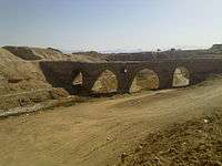
BagherAbad Bridge
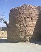
Jamshidi Castle
References
- ↑ https://www.amar.org.ir/english
- ↑ Nimvar can be found at GEOnet Names Server, at this link, by opening the Advanced Search box, entering "-3077031" in the "Unique Feature Id" form, and clicking on "Search Database".
- ↑ "Census of the Islamic Republic of Iran, 1385 (2006)". Islamic Republic of Iran. Archived from the original (Excel) on 2011-11-11.
| Capital | 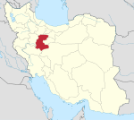 | ||||||||||||||||||||||||
|---|---|---|---|---|---|---|---|---|---|---|---|---|---|---|---|---|---|---|---|---|---|---|---|---|---|
| Counties and cities |
| ||||||||||||||||||||||||
| Sights |
| ||||||||||||||||||||||||
| populated places | |||||||||||||||||||||||||
This article is issued from
Wikipedia.
The text is licensed under Creative Commons - Attribution - Sharealike.
Additional terms may apply for the media files.