Nahavand
| Nahavand Nahāvand | |
|---|---|
| City | |
 Nahavand | |
| Coordinates: 34°11′19″N 48°22′37″E / 34.18861°N 48.37694°ECoordinates: 34°11′19″N 48°22′37″E / 34.18861°N 48.37694°E | |
| Country |
|
| Province | Hamadan |
| County | Nahavand |
| Bakhsh | Central |
| Population (2016 Census) | |
| • Total | 76,162 [1] |
| Time zone | UTC+3:30 (IRST) |
| • Summer (DST) | UTC+4:30 (IRDT) |
Nahavand (Persian: نهاوند, also Romanized as Nahāvand and Nehāvend)[2] is a city and capital of Nahavand County, Hamadan Province, Iran. At the 2006 census, its population was 72,218, in 19,419 families.[3] It is located south of Hamadan, east of Malayer and northwest of Borujerd. Nahavand is one of the oldest existing cities in Iran.
Name
It has been spelled differently in different books and sources: Nahavand, Nahavend, Nahawand, Nahaavand, Nehavand, Nihavand or Nehavend, formerly called Mah-Nahavand, and in antiquity Laodicea (Greek: Λαοδίκεια; Arabic Ladhiqiyya), also transliterated Laodiceia and Laodikeia, Laodicea in Media, Laodicea in Persis, Antiochia in Persis, Antiochia of Chosroes (Greek: Αντιόχεια του Χοσρόη), Antiochia in Media (Greek: Αντιόχεια της Μηδίας), Nemavand and Niphaunda.
History
Tepe Giyan is located in the area and consists of fine painted potteries from the 4th millennia BC.[4]
The city was founded by Darius I the Great, in Media along with the two other Achaemenid cities of Apamea and Xerxes. (Strabo xi. p. 524 ; Xerxes "Laodikeia") Pliny (vi. 29) describes it as being in the extreme limits of Media, and (re-)founded by Xerxes I.
The city was a center of Chosroes I's empire. After military reverses (ca. 540) following his sack of Syrian Antiochia in 538, he was forced to rename his capital "Antiochia".
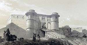
It is the site of the Battle of Nihawand in 642 that completed the fall of the Sassanid Empire and the Islamic conquest of Iran. It was ruled by Ottomans between 1589 and 1603 and again between 1734 and 1730.
Natives of Nahavand include Benjamin Nahawandi, who was a key figure in the development of Karaite Judaism in the Early Middle Ages, and 8th-century astronomer Ahmad Nahavandi, who worked at the Academy of Gundishapur. The Persian hero Feroze Nahavandi was born here. In another case they call Nahavand the city of secrets because there are a lot of cities under the current city.
Natural attractions
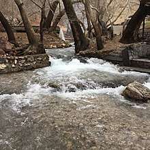
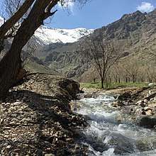
- Giyan Spring (Persian: سرآب گیان)
Giyan rivr and its springhead are among the most popular places in the region to spend time outside the city. It is located 22 km southwest of Nahavand and on the northern valleys of Garrin mountains.
Music
Nahavand also gives its name to the musical mode (maqam) Nahwand in Arabic, Persian and Turkish music. This mode is known for its wide variety of Western sounding melodies.
References
- Richard Talbert, Barrington Atlas of the Greek and Roman World, ( ISBN 0-691-03169-X), Map 92..
- ↑ https://www.amar.org.ir/english
- ↑ Nahavand can be found at GEOnet Names Server, at this link, by opening the Advanced Search box, entering "-3076227" in the "Unique Feature Id" form, and clicking on "Search Database".
- ↑ "Census of the Islamic Republic of Iran, 1385 (2006)". Islamic Republic of Iran. Archived from the original (Excel) on 2011-11-11.
- ↑ Langer, William L., ed. (1972). An Encyclopedia of World History (5th ed.). Boston, MA: Houghton Mifflin Company. p. 17. ISBN 0-395-13592-3.
External links
| Wikimedia Commons has media related to Nahavand. |
- Hamedan Province Cultural Heritage Website
- Persian History Website
- Smith, William (editor); Dictionary of Greek and Roman Geography, "Laodiceia", London, (1854)
![]()
| Capital | 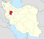 | ||||||||||||||||||
|---|---|---|---|---|---|---|---|---|---|---|---|---|---|---|---|---|---|---|---|
| Counties and cities |
| ||||||||||||||||||
| Sights |
| ||||||||||||||||||
| populated places | |||||||||||||||||||