Niers
| Niers | |
|---|---|
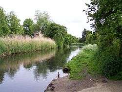 The Niers at Weeze | |
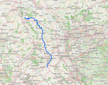 Overview map | |
| Country | Germany, Netherlands |
| Physical characteristics | |
| Main source |
Lower Rhine region ±75 m (246 ft) 51°04′49″N 6°23′31″E / 51.08028°N 6.39194°E |
| River mouth |
Maas 51°42′50″N 5°56′51″E / 51.71389°N 5.94750°ECoordinates: 51°42′50″N 5°56′51″E / 51.71389°N 5.94750°E |
| Length | 113.1 km (70.3 mi) [1] |
| Basin features | |
| Progression | Meuse→ North Sea |
| Basin size | 1,373 km2 (530 sq mi) [1] |
The Niers (spoken-out like neerce) is a river in Germany and The Netherlands, a right tributary of the river Maas (Meuse). Its wellspring is near Erkelenz, south of Mönchengladbach, in North Rhine-Westphalia (Germany).
Course and length
The Niers flows through Mönchengladbach, Viersen, Wachtendonk, Geldern and Goch before flowing into the Meuse just across the border with the Netherlands, in Gennep, Limburg (Netherlands).
Its overall length is 116 km - 108 km in Germany, 8 km in the Netherlands.
See also
References
External links
This article is issued from
Wikipedia.
The text is licensed under Creative Commons - Attribution - Sharealike.
Additional terms may apply for the media files.