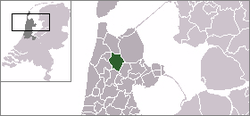
Niedorp
| Niedorp | |||
|---|---|---|---|
| Former municipality | |||
| |||
 | |||
| Coordinates: 52°44′N 4°54′E / 52.73°N 4.90°ECoordinates: 52°44′N 4°54′E / 52.73°N 4.90°E | |||
| Country | Netherlands | ||
| Province | North Holland | ||
| Municipality | Hollands Kroon | ||
| Area(2006) | |||
| • Total | 62.99 km2 (24.32 sq mi) | ||
| • Land | 61.58 km2 (23.78 sq mi) | ||
| • Water | 1.41 km2 (0.54 sq mi) | ||
| Population (1 January 2007) | |||
| • Total | 11,987 | ||
| • Density | 195/km2 (510/sq mi) | ||
| Source: CBS, Statline. | |||
| Time zone | UTC+1 (CET) | ||
| • Summer (DST) | UTC+2 (CEST) | ||
| Website | www.niedorp.nl | ||
![]()
Population centres
The former municipality of Niedorp consisted of the following cities, towns, villages and/or districts: Barsingerhorn, Haringhuizen, Kolhorn, Lutjewinkel, Nieuwe Niedorp, Oude Niedorp, 't Veld, Winkel, Zijdewind.
Archaeology
Prehistoric settlements from the Late Neolithic were found in De Gouw and the Groetpolder. They are covered by sediment and belong to the Single Grave Culture. In 1995, these sites were submitted to UNESCO's list of World Heritage Sites. They are currently on the tentative list.[1][2]
Local government
The former municipal council of Niedorp consisted of 15 seats, which were divided as follows:
References
- Statistics are taken from the SDU Staatscourant
- ↑ Tentative List for the Netherlands Archived 2007-12-24 at Archive.is. The World Heritage Platform. Retrieved on 2009-07-23.
- ↑ De Gouw and de Groetpolder. UNESCO World Heritage Centre. Retrieved on 2009-07-23.
External links
| Wikimedia Commons has media related to Niedorp. |
- City Site (Dutch)
- Nieuws over Niedorp (Dutch)
- Alles over Schagen FM, de lokale omroep voor Schagen, Zijpe, Niedorp en Harenkarspel (Dutch)