Gau Island
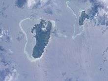
Gau (pronounced [ˈŋau]) is an island belonging to Fiji's Lomaiviti Archipelago. Located at 18.00° S and 179.30 °E, it covers an area of 136.1 square kilometres (52.5 square miles), with a total shoreline that measures 66.3 kilometres (41.2 miles) long, making it the 5th largest island in the Fijian archipelago. Its maximum altitude is 738 metres (2,421 ft).
A 5,200 hectares (13,000 acres) area covering the entire forested interior (just over 50% of the entire island) is the Gau Highlands Important Bird Area. It contains populations of the critically endangered Fiji petrel, and vulnerable Shy Ground-dove and Collared Petrel.[1] The Fiji petrel nesting habitat on the island contributes to its national significance as outlined in Fiji's Biodiversity Strategy and Action Plan.[2]
It has one airstrip at Lovu, on the southern tip of the island, which receives planes from Nausori International Airport.
A marine research facility was established on Naviavia beach on the western coast of Gau in 2005 by UK based NGO Frontier, commissioned by Dr. Joeli Veitayaki of the University of South Pacific, a native of Malawai on the eastern coast.
Rugby sevens legend and former player-coach of the Fijian national Sevens Team Waisale Serevi is a native of Qarani, a large village to the north-west, which also contains a post office and nursing station.
References
- ↑ "BirdLife Data Zone". datazone.birdlife.org. Retrieved 29 May 2017.
- ↑ Ganilau, Bernadette Rounds (2007). Fiji Biodiversity Strategy and Action Plan (PDF). Convention on Biological Diversity. pp. 107–112. Retrieved 28 May 2017.