Newkirk, New Mexico
| Newkirk, New Mexico | |
|---|---|
| Census-designated place | |
 | |
 Newkirk  Newkirk | |
| Coordinates: 35°04′06″N 104°15′53″W / 35.06833°N 104.26472°WCoordinates: 35°04′06″N 104°15′53″W / 35.06833°N 104.26472°W | |
| Country | United States |
| State | New Mexico |
| County | Guadalupe |
| Area[1] | |
| • Total | 1.088 sq mi (2.82 km2) |
| • Land | 1.088 sq mi (2.82 km2) |
| • Water | 0 sq mi (0 km2) |
| Elevation | 4,560 ft (1,390 m) |
| Population (2010)[2] | |
| • Total | 7 |
| • Density | 6.4/sq mi (2.5/km2) |
| Time zone | UTC-7 (Mountain (MST)) |
| • Summer (DST) | UTC-6 (MDT) |
| ZIP code | 88431 |
| Area code(s) | 575 |
| GNIS feature ID | 918267[3] |
Newkirk is a census-designated place in Guadalupe County, New Mexico, United States. The community is located at the junction of Interstate 40 and New Mexico State Road 129; historic U.S. Route 66 also passes through the community. Its population was 7 as of the 2010 census. Newkirk has a post office with ZIP code 88431.[4][5]
Notable people
- Fabiola Cabeza de Baca Gilbert (1894-1991) - educator, nutritionist, activist, writer, inventor of the u-shaped fried taco shell.
References
- ↑ "US Gazetteer files: 2010, 2000, and 1990". United States Census Bureau. 2011-02-12. Retrieved 2011-04-23.
- ↑ "American FactFinder". United States Census Bureau. Retrieved 2011-05-14.
- ↑ "Newkirk". Geographic Names Information System. United States Geological Survey.
- ↑ United States Postal Service (2012). "USPS - Look Up a ZIP Code". Retrieved 2012-02-15.
- ↑ "Postmaster Finder - Post Offices by ZIP Code". United States Postal Service. Retrieved September 22, 2013.
External links
![]()
Municipalities and communities of Guadalupe County, New Mexico, United States | ||
|---|---|---|
| City | 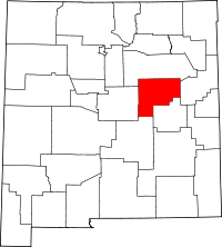 | |
| Town | ||
| CDPs | ||
| Other unincorporated community | ||
This article is issued from
Wikipedia.
The text is licensed under Creative Commons - Attribution - Sharealike.
Additional terms may apply for the media files.