Newbury, Ontario
| Newbury | |
|---|---|
| Village (lower-tier) | |
| Village of Newbury | |
 | |
 Newbury | |
| Coordinates: 42°41′00″N 81°47′50″W / 42.68333°N 81.79722°WCoordinates: 42°41′00″N 81°47′50″W / 42.68333°N 81.79722°W | |
| Country |
|
| Province |
|
| County | Middlesex |
| Settled | 1851 |
| Incorporated | 1873 |
| Government | |
| • Reeve | Diane Brewer |
| • Federal riding | Lambton—Kent—Middlesex |
| • Prov. riding | Lambton—Kent—Middlesex |
| Area[1] | |
| • Land | 1.85 km2 (0.71 sq mi) |
| Population (2011)[1] | |
| • Total | 447 |
| • Density | 241.0/km2 (624/sq mi) |
| Time zone | UTC-5 (EST) |
| • Summer (DST) | UTC-4 (EDT) |
| Postal Code | N0L |
| Area code(s) | 519 and 226 |
| Website | www.newbury.ca |
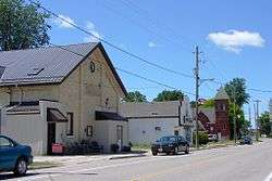
Newbury is a village in the Canadian province of Ontario, located in Middlesex County. It is located in the southwestern corner of the county, entirely surrounded by the municipality of Southwest Middlesex. The Four Counties Health Services Hospital is based in Newbury and is part of the Middlesex Hospital Alliance.[2] The hospital serves approximately 23,000 residents, primarily from the Village of Newbury, Lambton, Kent, Middlesex and Elgin Counties.[3]
History
The village got its start in 1851 when the Great Western Railway was built through the area. The first house built was located south of the railroad in 1851 by Eobert Thompson.[4] The settlement was originally known as Ward's Station, but was renamed in 1854 after the namesake town in England since most of the residents were of English and Irish origin. That same year, the post office opened with Robert Thompson as first postmaster.[5]
By 1872, Newbury's population had reached 750 people. The following year it was incorporated as a village. During those early years, Newbury had a flourmill, seven hotels, three churches, a school, library, fire hall, and a basket factory.[5] In January 1873, Newbury’s first council was elected.[6]
In 1967, the Four Counties General Hospital opened, followed by the Newbury Medical Clinic in 1972.[5]
Demographics
| Canada census – Newbury, Ontario community profile | |||
|---|---|---|---|
| 2011 | 2006 | ||
| Population: | 447 (1.8% from 2006) | 439 (4.0% from 2001) | |
| Land area: | 1.85 km2 (0.71 sq mi) | 1.85 km2 (0.71 sq mi) | |
| Population density: | 241.0/km2 (624/sq mi) | 236.7/km2 (613/sq mi) | |
| Median age: | 43.7 (M: 43.5, F: 44.0) | 39.8 (M: 38.5, F: 40.8) | |
| Total private dwellings: | 193 | 183 | |
| Median household income: | $32,473 | ||
| References: 2011[1] 2006[7] earlier[8] | |||
Population trend:[9]
- Population in 2006: 439
- Population in 2001: 422
- Population in 1996: 430
- Population in 1991: 419
References
- 1 2 3 "2011 Community Profiles". Canada 2011 Census. Statistics Canada. July 5, 2013. Retrieved 2012-07-23.
- ↑ Southwesthealthline.ca (n.d). "Four Counties Health Services". Retrieved 2018-05-25.
- ↑ Middlesex Hospital Alliance (n.d). "FCHS site". Retrieved 2018-05-25.
- ↑ Newbury Village (1889)."History of the County of Middlesex, Canada : from the earliest time to the present, containing an authentic account of many important matters relating to the settlement, progress and general history of the county, and including a department devoted to the preservation of personal and private records, etc. ; illustrated". Retrieved 2018-05-25.
- 1 2 3 "The History of Newbury". The Corporation of the Village of Newbury. Retrieved 2011-02-16.
- ↑ Ontario's Historical Plaques (n.d). "The Founding of Newbury". Retrieved 2018-05-25.
- ↑ "2006 Community Profiles". Canada 2006 Census. Statistics Canada. March 30, 2011. Retrieved 2011-02-16.
- ↑ "2001 Community Profiles". Canada 2001 Census. Statistics Canada. February 17, 2012.
- ↑ Statistics Canada: 1996, 2001, 2006 census
External links
Places adjacent to Newbury, Ontario | |
|---|---|