New Tazewell, Tennessee
| New Tazewell, Tennessee | |
|---|---|
| Town | |
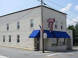 City Hall, New Tazewell | |
 Location of New Tazewell in Claiborne County, Tennessee. | |
| Coordinates: 36°26′16″N 83°36′27″W / 36.43778°N 83.60750°WCoordinates: 36°26′16″N 83°36′27″W / 36.43778°N 83.60750°W | |
| Country | United States |
| State | Tennessee |
| County | Claiborne |
| Established | 1880s[1] |
| Incorporated | 1954[1] |
| Government | |
| • Mayor | Jerry Beeler |
| Area | |
| • Total | 5.3 sq mi (13.7 km2) |
| • Land | 5.3 sq mi (13.7 km2) |
| • Water | 0.0 sq mi (0.0 km2) |
| Elevation | 1,463 ft (446 m) |
| Population (2010) | |
| • Total | 3,037 |
| • Estimate (2016)[2] | 2,767 |
| • Density | 570/sq mi (220/km2) |
| Time zone | UTC-5 (Eastern (EST)) |
| • Summer (DST) | UTC-4 (EDT) |
| ZIP codes | 37824-37825 |
| Area code(s) | 423 Exchanges: 562,626,851 |
| FIPS code | 47-53140[3] |
| GNIS feature ID | 1295652[4] |
| Website | http://newtazewelltn.org/ |
New Tazewell is a town in Claiborne County, Tennessee, United States. The population was 3,037 at the 2010 census.
Geography
New Tazewell is located at 36°26′16″N 83°36′27″W / 36.43778°N 83.60750°W (36.437838, -83.607613).[5] According to the United States Census Bureau, the town has a total area of 5.3 square miles (14 km2), all land.
Demographics
| Historical population | |||
|---|---|---|---|
| Census | Pop. | %± | |
| 1960 | 768 | — | |
| 1970 | 1,192 | 55.2% | |
| 1980 | 1,677 | 40.7% | |
| 1990 | 1,864 | 11.2% | |
| 2000 | 2,871 | 54.0% | |
| 2010 | 3,037 | 5.8% | |
| Est. 2016 | 2,767 | [2] | −8.9% |
| Sources:[6][7] | |||
As of the census[3] of 2000, there were 2,871 people, 1,200 households, and 753 families residing in the town. The population density was 542.2 people per square mile (209.2/km²). There were 1,414 housing units at an average density of 267.0 per square mile (103.0/km²). The racial makeup of the town was 96.20% White, 1.46% African American, 0.45% Native American, 0.42% Asian, 0.77% from other races, and 0.70% from two or more races. Hispanic or Latino of any race were 1.04% of the population. There were 1,200 households out of which 29.4% had children under the age of 18 living with them, 43.8% were married couples living together, 14.6% had a female householder with no husband present, and 37.3% were non-families. 34.1% of all households were made up of individuals and 14.7% had someone living alone who was 65 years of age or older. The average household size was 2.30 and the average family size was 2.97.
In the town, the population was spread out with 24.1% under the age of 18, 8.7% from 18 to 24, 27.8% from 25 to 44, 23.3% from 45 to 64, and 16.1% who were 65 years of age or older. The median age was 37 years. For every 100 females, there were 84.6 males. For every 100 females age 18 and over, there were 82.5 males.
The median income for a household in the town was $21,875, and the median income for a family was $31,458. Males had a median income of $22,181 versus $18,472 for females. The per capita income for the town was $13,619. About 24.2% of families and 29.4% of the population were below the poverty line, including 40.1% of those under age 18 and 32.1% of those age 65 or over.
History
When the railroad line was built from Knoxville through Cumberland Gap in the late 1880s, it bypassed the town of Tazewell. It is uncertain whether the railroad was unable to obtain right of way, or whether the decision was made because of topography, but the railroad depot was built about two miles to the west of Tazewell. A new community sprang up around the depot, called Cowan City on old survey maps. The town was incorporated as New Tazewell in the 1920s, but the charter was voted down about fifteen years later. It was reincorporated in 1954.[1] The town of New Tazewell was soon a thriving commercial location. Entrepreneur John L. Buis built a two-story brick building across from the train depot where he opened the Cherokee Hotel. The building also housed the first post office and a general store, and was served by a livery stable just down the street. Buis also bought farms in the area and opened a cannery in Tazewell where he produced canned goods to ship north by railroad.
Burley tobacco production in the area provided a cash crop, and warehouses were built in the town for tobacco auctions in the late fall and early winter. Tobacco buyers came in by train and stayed at the hotel, with easy access to the warehouses by walking or by horse and buggy from the livery stable.
As burley tobacco production declined in the United States, the warehouses were abandoned, and the local economy shifted from farming to manufacturing. Today, the railroad carries freight from New Tazewell, mostly timber.
Government
New Tazewell city government includes a mayor and six aldermen. The Town has a police department and a fire department shared with the town of Tazewell. It also features a small airport with a 5,200-foot runway.
Education
New Tazewell is Home to a Satellite Campus of Walters State Community College.
Local economy
New Tazewell is home to a number of factories, including furniture manufacturer England Furniture Incorporated now a division of La-Z-Boy, DeRoyal Industries, Bushline Furniture, King Business Forms, Giles Industries, Homesteader Cargo Trailers, Volunteer Knit Apparel, Inc. and others.
References
| Wikimedia Commons has media related to New Tazewell, Tennessee. |
- 1 2 3 "History of the Town of New Tazewell". Retrieved 26 May 2012.
- 1 2 "Population and Housing Unit Estimates". Retrieved June 9, 2017.
- 1 2 "American FactFinder". United States Census Bureau. Retrieved 2008-01-31.
- ↑ "US Board on Geographic Names". United States Geological Survey. 2007-10-25. Retrieved 2008-01-31.
- ↑ "US Gazetteer files: 2010, 2000, and 1990". United States Census Bureau. 2011-02-12. Retrieved 2011-04-23.
- ↑ "Census of Population and Housing: Decennial Censuses". United States Census Bureau. Retrieved 2012-03-04.
- ↑ "Incorporated Places and Minor Civil Divisions Datasets: Subcounty Resident Population Estimates: April 1, 2010 to July 1, 2012". Population Estimates. U.S. Census Bureau. Archived from the original on 17 June 2013. Retrieved 11 December 2013.
Municipalities and communities of Claiborne County, Tennessee, United States | ||
|---|---|---|
| City | ||
| Towns | ||
| Unincorporated communities | ||
| Footnotes | ‡This populated place also has portions in an adjacent county or counties | |