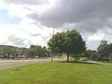
New Farm Loch
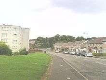
The large New Farm Loch estate to the North-East of Kilmarnock, East Ayrshire, Scotland and was created in the late 1960s by a number of builders to accommodate the growing population of Kilmarnock. New Farm Loch officially opened in 1968 with the first houses to be occupied by residents in 1968 were at MacDonald Drive, MacKenzie Drive, MacKinnon Drive, MacLeod Place, MacNab Place, MacNaughton Drive and MacNeil Place[1].
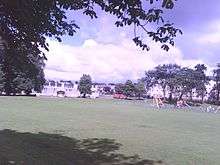
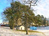
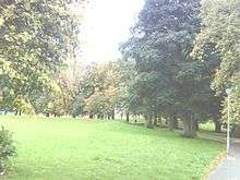
The Newfarm loch
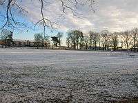
The loch was constructed there by co-operation between the Duke of Portland's factor and the local curling clubs. Newfarm Loch, which was once popular as a curling rink, was rented by several curling clubs,[2][3]
The loch site is still bordered by mature trees planted to provide shelter for the curlers. It is however surrounded on three sides by houses and apartments built between 1968 and the mid-1970s. New Farm itself no longer exists; it stood about one field's distance away from the loch.
Prior to being built up, New Farm Loch on the north east side of Kilmarnock was prone to seasonal flooding. In winter, when the water froze over, it was used as a curling rink.[4] As well as curling, the frozen pond at New Farm Loch in Kilmarnock was popular with skaters.[5]
The Estate
The estate was built on the lands of South Dean Farm, Newfarm, and parts of Whinpark Farm and West Wardlaw Farm. The latter two still survive, and South Dean Farm is retained in the name of South Dean Road, along which it sat. The working class estate is a warren of streets, split by a central carriageway named Grassyards Road. One side of the road is known locally as 'The Courts'. New Farm Loch was built by Scottish Special Housing.
Transport
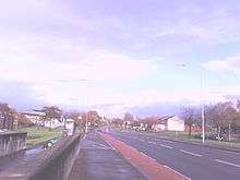
The area is located about two miles North and East from Kilmarnock town centre which contains the town's Bus and Train stations. The Number 6,7 and X16 StageCoach Bus services are frequent, looping around New Farm Loch (apart from the X16) and back to the town centre. There is also a Glasgow commuter service passing along Grassyards Road and onto the A77, located on the outskirts of the area.
Facilities and Amenities
New Farm had, until April 2018, 3 primary schools, namely Silverwood Primary, St. Andrews Primary (connected with St. Josephs Academy) and New Farm Primary (connected with James Hamilton Academy). New Farm and Silverwood Primaries have merged to become James Hamilton Primary whilst the Gaelic School previously based at Onthank Primary has now relocated to New Farm Loch.
Until 2018 there were two secondary schools in New Farm Loch the James Hamilton Academy and the town's only Roman Catholic Secondary School, St. Josephs Academy, which was re-built in 2008. In April 2018 James Hamilton Academy meged with nearby Kilmarnock Academy and is housed in the new William McILvanney Campus along with James Hamilton Primary and the Gaelic School, Kilmarnock Academy is now the non-denominational Secondary School within New Farm Loch.
East Ayrshire Council approved plans for the merger of James Hamilton Academy with Kilmarnock Academy to create a new secondary school and the merger of New Farm Primary School and Early Childhood Centre with Silverwood Primary School to create a new primary school with Early Childhood Centre, which will be co-located on a 3-18 campus on the existing Sutherland Drive site. The completion of this project was in 2018.[6] New Farm Loch also contains Willowbank School, which caters for primary and secondary children with a range of severe, complex and profound additional support needs.
Two churches exist in the estate: St. Kentigern's Parish Church in the presbytery of Irvine and Kilmarnock is a Church of Scotland parish church covering virtually all of New Farm Loch in its parish,[7] and St. Matthew's is a Roman Catholic church in the Diocese of Galloway.[8] St Matthew's website address is . The churches are located across from each other. There are good relations and significant ecumenical cooperation between these two Christian communities. Also located in the area is a community centre, Kay Park Bowling Club, a public house (The Charleston) and numerous shops and businesses. The Kay Park, Dean Castle Country Park and Kilmarnock Cemetery are all close by.
References
Notes
- ↑ https://www.facebook.com/475344285963552/photos/a.517882798376367.1073741830.475344285963552/1065576933606948/?type=3&theater
- ↑ McKay, Page 135
- ↑ Curlers on Newfarm Loch Retrieved : 2010-12-28
- ↑ "Curling on New Farm Loch". futuremuseum.co.uk. 2012. Retrieved 16 November 2013.
- ↑ "Skating at New Farm Loch". futuremuseum.co.uk. Retrieved 16 November 2013.
- ↑ "East Ayrshire Council Consultation Report" (PDF). Archived from the original (PDF) on 5 May 2014. Retrieved 5 May 2014.
- ↑ "St Kentigern's Parish Church: About us". www.stkentigern.org.uk. Retrieved 16 November 2013.
- ↑ "Diocese of Galloway". www.gallowaydiocese.org.uk. Archived from the original on 22 July 2012. Retrieved 16 November 2013.
Sources
- McKay, Archibald (1880). The History of Kilmarnock. Kilmarnock : Archibald McKay. The Dick Institute Early records of Kilmarnock.
External links
| Wikimedia Commons has media related to Newfarm Loch. |