Flamingo Road (Las Vegas)
| ||||
|---|---|---|---|---|
| Flamingo Road | ||||
| Route information | ||||
| Maintained by NDOT | ||||
| Length | 8.487 mi[1] (13.659 km) | |||
| Section 1 | ||||
| Length | 3.614 mi[1] (5.816 km) | |||
| West end |
| |||
| East end |
| |||
| Section 2 | ||||
| Length | 4.873 mi[1] (7.842 km) | |||
| West end | Paradise Road | |||
| Major junctions |
| |||
| East end |
| |||
| Highway system | ||||
| ||||

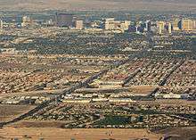
State Route 592 (SR 592) is a 8.487-mile (13.659 km) east–west highway section line arterial in the Las Vegas Valley. The highway currently exists in two separate sections on Flamingo Road. The road is named after the Flamingo Hotel which is located on the Las Vegas Boulevard near where it intersects with Flamingo Road.
Route description
_near_Las_Vegas%2C_Nevada.jpg)
The first portion of SR 592 begins at Rainbow Boulevard (SR 595) and extends easterly to Interstate 15. The second section resumes at Paradise Road and continues east, skirting the northern edge of the University of Nevada, Las Vegas campus before reaching its terminus at Boulder Highway (SR 582).
History
Flamingo Road originally was called Monson Road, and only existed east of Las Vegas Boulevard, with a nearby street, Dunes Road connecting Las Vegas Boulevard with Interstate 15 (I-15). In the early 1980s, the Nevada Department of Transportation rebuilt the Dunes interchange at I-15, and constructed a six-lane Flamingo Road west to Rainbow Boulevard.
The segment between I-15 and Las Vegas Boulevard remained named Dunes-Flamingo Road until 1995.
The portion of SR 592 between I-15 and Paradise Road was decommissioned by 2008.
The route is a candidate to be decommissioned with control given to Clark County; however, only the above section located in the resort corridor has been relinquished as of January 2008.
Major intersections
The entire route is in Clark County.
| Location | mi | km | Destinations | Notes | |||
|---|---|---|---|---|---|---|---|
| | Rainbow Boulevard (SR 595) | ||||||
| | Jones Boulevard (SR 596) | ||||||
| | I-15 exit 38. | ||||||
| Gap in route | |||||||
| | Paradise Road | ||||||
| | I-515 exit 69. | ||||||
| | Boulder Highway (SR 582) | ||||||
| 1.000 mi = 1.609 km; 1.000 km = 0.621 mi | |||||||
Attractions
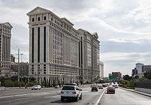
- Palms Casino Resort
- Gold Coast Hotel and Casino
- Bellagio
- Caesars Palace
- Bally's Las Vegas
- Bill's Gamblin' Hall and Saloon
- Desert Springs Hospital
Public transport
RTC Transit Route 202 functions on this road.
See also
| Wikimedia Commons has media related to Flamingo Road (Las Vegas). |


References
Route map:
- 1 2 3 Nevada Department of Transportation (January 2017). "State Maintained Highways of Nevada: Descriptions and Maps". Retrieved 2017-03-11.