Nevada State Route 228
| ||||
|---|---|---|---|---|
| Jiggs Highway | ||||
 | ||||
| Route information | ||||
| Maintained by NDOT | ||||
| Length | 26.814 mi[1] (43.153 km) | |||
| Existed | 1976 – present | |||
| Major junctions | ||||
| South end | Jiggs | |||
| North end |
| |||
| Highway system | ||||
| ||||

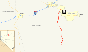
State Route 228 (SR 228) is a state highway in Elko County, Nevada, United States. Known as Jiggs Highway, the route is a spur connecting SR 227 (Lamoille Highway) in Spring Creek to the community of Jiggs. Although the actual state highway designation ends just south of Jiggs, the paved road continues south as Elko County Route 717, then turns east as Elko County Route 718, eventually reaching Ruby Valley via Harrison Pass.[2] Pavement does not actually end until just before the pass itself.
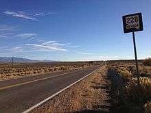
View from the north end of SR 228 looking southbound
History
SR 228 was designated as part of State Route 46 prior to 1976.[1]
Major intersections
The entire route is in Elko County.
| Location | mi | km | Destinations | Notes | |
|---|---|---|---|---|---|
| Jiggs | Jiggs Road | Continuation beyond terminus | |||
| | |||||
| 1.000 mi = 1.609 km; 1.000 km = 0.621 mi | |||||
See also


References
Route map:
- 1 2 Nevada Department of Transportation (January 2017). "State Maintained Highways of Nevada: Descriptions and Maps". Retrieved 2017-04-28.
- ↑ "ELKO COUNTY HIGHWAY DEPARTMENT ROAD SYSTEM" (PDF). Retrieved July 29, 2013.
| Wikimedia Commons has media related to Nevada State Route 228. |
This article is issued from
Wikipedia.
The text is licensed under Creative Commons - Attribution - Sharealike.
Additional terms may apply for the media files.