Nevada State Route 119
| ||||
|---|---|---|---|---|
| Berney Road | ||||
 Nevada State Route 119, highlighted in red. | ||||
| Route information | ||||
| Maintained by NDOT | ||||
| Length | 4.137 mi[1] (6.658 km) | |||
| Existed | December 31, 1991 – present | |||
| Major junctions | ||||
| West end |
| |||
| East end | Beach Road in the southwest corner of NAS Fallon | |||
| Location | ||||
| Counties | Churchill | |||
| Highway system | ||||
| ||||

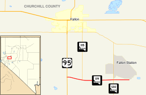
State Route 119 is a state highway in Nevada, United States. It connects U.S. Route 95 east to NAS Fallon as part of Berney Road.
_in_Churchill_County%2C_Nevada.jpg)
View from the west end of SR 119 looking eastbound
Major intersections
The entire route is in Churchill County.
| Location | mi | km | Destinations | Notes | |
|---|---|---|---|---|---|
| | 0.00 | 0.00 | |||
| | Southern terminus of NV 115 | ||||
| | Northern terminus of NV 120 | ||||
| | 4.137 | 6.658 | Beach Road | Gate to NAS Fallon | |
| 1.000 mi = 1.609 km; 1.000 km = 0.621 mi | |||||
References
Route map:
- ↑ Nevada Department of Transportation (January 2017). "State Maintained Highways of Nevada: Descriptions and Maps". Retrieved 7 May 2017.
| Wikimedia Commons has media related to Nevada State Route 119. |
This article is issued from
Wikipedia.
The text is licensed under Creative Commons - Attribution - Sharealike.
Additional terms may apply for the media files.