Nesjavellir Geothermal Power Station
| Nesjavellir Geothermal Power Station | |
|---|---|
 Nesjavellir Geothermal Power Station | |
| Country | Iceland |
| Location | Thingvellir |
| Coordinates | 64°06′29″N 21°15′23″W / 64.10806°N 21.25639°WCoordinates: 64°06′29″N 21°15′23″W / 64.10806°N 21.25639°W |
| Status | Operational |
| Commission date | May 1990 |
| Owner(s) | ON Power |
| Geothermal power station | |
| Type | Flash steam |
| Min. source temp. | 190 °C (374 °F) |
| Wells | 21 in use |
| Max. well depth | 2,000 m (6,600 ft) |
| Cogeneration? | Yes |
| Combined cycle? | Yes |
| Power generation | |
| Units operational | 4 × 30MW |
| Thermal capacity | 300 MWt |
| CHP heating capacity | 150 MWt |
| Nameplate capacity | 120 MWe |
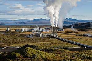
The Nesjavellir Geothermal Power Station (NGPS) is the second-largest geothermal power station in Iceland. The facility is located 177 m (581 ft) above sea level in the southwestern part of the country, near Thingvellir and the Hengill Volcano. NGPS is owned and operated by ON Power.
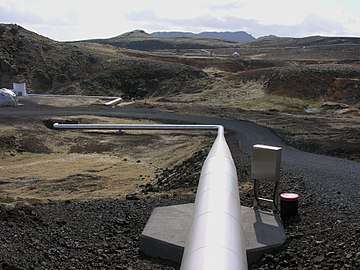
Plans for utilizing the Nesjavellir area for geothermal power and water heating began in 1947, when some boreholes were drilled to evaluate the area's potential for power generation. Research continued from 1965 to 1986. In 1987, the construction of the plant began, and the cornerstone was laid in May 1990. The station produces approximately 120 MW of electrical power; it also delivers around 1,100 litres (290 US gal) of hot water (82-85 °C) per second, servicing the space heating and hot water needs of the Capital Region.

See also
| Wikimedia Commons has media related to Nesjavallavirkjun. |