Neighborhoods in Providence, Rhode Island
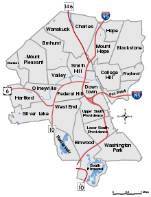
Providence neighborhoods with major highways shown

The Providence Skyline viewed from College Hill
The city of Providence, Rhode Island has 25 official neighborhoods.[1]
Many of these neighborhoods are often grouped together referred to collectively:
- East Side - region of Blackstone, Hope (aka Summit), Mount Hope, College Hill, Wayland, and Fox Point.[2]
- Jewelry District - the area around Davol Square. This area will be united with Downtown after the completion of the Iway project to move I-195 south.[3][4]
- North End - sometimes given collectively to the neighborhoods of Charles, Wanskuck, Smith Hill, Elmhurst, and Mount Pleasant.[3]
- South Side or South Providence - region consisting of the neighborhoods of Elmwood, Lower South Providence, Upper South Providence.[3]
- West End - an area of Federal Hill and West Broadway along the western portion of Westminster Street.[5][6]
The oldest, highest density neighborhoods are either those close to downtown or proximate to the Woonasquatucket River, which provided a power source for early industrialization in Manton, Hartford, and Olneyville. More distant neighborhoods developed later, mostly as transportation as public horse car and streetcar lines were added.
References
- ↑ "Providence Neighborhoods". City of Providence. Retrieved 2007-01-17.
- ↑ "Providence Neighborhood Profiles: Alternative Neighborhood Names". The Providence Plan. 2007. Archived from the original on 2008-10-11. Retrieved 2007-01-31.
- 1 2 3 Providence Neighborhood Profiles Archived 2007-09-28 at the Wayback Machine.
- ↑ The Jewelry District
- ↑ Providence Neighborhoods: West Broadway
- ↑ WBNA - Home
| Wikimedia Commons has media related to Providence Neighborhoods. |
This article is issued from
Wikipedia.
The text is licensed under Creative Commons - Attribution - Sharealike.
Additional terms may apply for the media files.