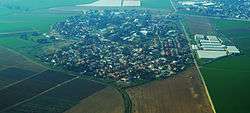
Nehora
| Nehora נְהוֹרָה | |
|---|---|
 | |
 Nehora | |
| Coordinates: 31°37′21.35″N 34°42′17.64″E / 31.6225972°N 34.7049000°ECoordinates: 31°37′21.35″N 34°42′17.64″E / 31.6225972°N 34.7049000°E | |
| District | Southern |
| Council | Lakhish |
| Founded | 1955 |
| Population (2017)[1] | 1,168 |
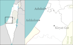
Nehora (Hebrew: נְהוֹרָה) is a moshav in southern Israel. Located on the coastal plain about 5 km west Kiryat Gat in south-central Israel and just to the east of Route 352, across the road from Noga, it falls under the jurisdiction of Lakhish Regional Council. In 2017 it had a population of 1,168.[1]
History
Nehora was founded in 1955 as part of the program to inhabit Hevel Lakhish and was intended to serve as a center of services for surrounding communities. A shopping center, regional school and the offices of the Lakhish Regional Council are located there.
It is built on the land of the depopulated Palestinian village of Karatiyya.[2]
References
- 1 2 "List of localities, in Alphabetical order" (PDF). Israel Central Bureau of Statistics. Retrieved August 26, 2018.
- ↑ Khalidi, Walid (1992). All That Remains: The Palestinian Villages Occupied and Depopulated by Israel in 1948. Washington D.C.: Institute for Palestine Studies. p. 119. ISBN 0-88728-224-5.
This article is issued from
Wikipedia.
The text is licensed under Creative Commons - Attribution - Sharealike.
Additional terms may apply for the media files.