South Dakota Highway 87
| ||||
|---|---|---|---|---|
 Route of SD 87 (in red) | ||||
| Route information | ||||
| Defined by SDCL §31-4-182 | ||||
| Maintained by SDDOT | ||||
| Length | 37.894 mi[1] (60.984 km) | |||
| Restrictions | Closed in winter | |||
| Major junctions | ||||
| South end |
| |||
| North end |
| |||
| Location | ||||
| Counties | Custer, Pennington | |||
| Highway system | ||||
| ||||

 .jpg) |
| Southwestern South Dakota |
|---|
| Sculptures |
| Geologic and natural history |
| Mountains |
| Caves |
| Forests and wildernesses |
| Lakes |
| Scenic byways |
South Dakota Highway 87 (SD 87) is a 37.894-mile-long (60.984 km) state highway in the southwestern part of the U.S. state of South Dakota. It travels through the Black Hills region. The highway's southern terminus is at an intersection with U.S. Route 385 (US 385), about 6 miles (9.7 km) southeast of Pringle, within the southwestern part of Wind Cave National Park. Its northern terminus is at an intersection with US 16/US 385 about 3 miles (4.8 km) south-southwest of Hill City, within the east-central part of the Black Hills National Forest.
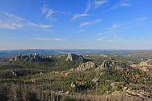
The highway travels through Wind Cave National Park and Custer State Park. The northern 14 miles (23 km) of the highway is also known as the Needles Highway. The Needles Highway, along with the concurrency with US 16A, are also part of the Peter Norbeck Scenic Byway. Portions of the highway are also a section of Custer State Park's Wildlife Loop.
Route description
Because of the highway's mountainous, curving nature, it is closed during the winter.[2]
South of US 16A
Highway 87 begins at US 385 in Wind Cave National Park, east of Pringle and west of the park headquarters. North of US 385, the route crosses Cold Spring Creek and provides access to the upstream Lake Norbeck, named after Senator Peter Norbeck, instrumental in establishing several of the national and state parks in the Black Hills. From the start, SD 87 is a very twisting and winding route, with a 180° hairpin turn only a one-half mile (800 m) from the southern end. This results in the route taking a westerly track, though it eventually turns back north and crosses Beaver Creek. Three miles (4.8 km) into the route, it bridges itself and executes a 270° turn.[3]
The route enters Custer State Park one mile (1.6 km) north of US 385.[1] Admission to the park requires an entrance license; as of 2009, the fee is $20 per vehicle.[4] Highway 87 then becomes part of the park's Wildlife Loop, and runs through the town of Blue Bell.
At milepost 17.180 (27.649 km), Highway 87 intersects U.S. Route 16A.[1] From this point onward, the road is part of the Peter Norbeck Scenic Byway.[5] The two routes form a concurrency and proceed east, passing Legion Lake.[3] The roads split after just under 1.5 miles (2.4 km).[6]
Needles Highway
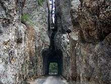
After splitting from US 16A, the route is known as the Needles Highway. This segment is 14 miles (23 km) long.[7] Finished in 1922,[7] the highway is named after the high granite "needles" it winds among. Access to the Needles Highway requires a Custer State Park entrance license, making that portion of SD 87 a toll road. Along this stretch lies the Black Hills Playhouse. The highway passes through two tunnels blasted through sheer granite walls—Iron Creek Tunnel and Needles Eye Tunnel.[1] Owing to the narrow roadway, sharp turns, and low tunnels, the road has very little traffic. The vehicles that do travel this road are almost exclusively sightseers.
Just after Needles Eye Tunnel, Highway 87 serves as the northern terminus of SD 89. After this junction, SD 87 has one more tunnel, Hood Tunnel.[1] It then provides access to the Sylvan Lake Resort. The route finally ends at US 16/385 south of Hill City.

Major intersections
| County | Location | mi[1][6] | km | Destinations | Notes |
|---|---|---|---|---|---|
| Custer | Wind Cave National Park | 0.000 | 0.000 | Southern terminus | |
| Custer State Park | 17.810 | 28.662 | Southern end of US 16A concurrency | ||
| 19.298 | 31.057 | Northern end of US 16A concurrency | |||
| 31.929 | 51.385 | Northern terminus of SD 89 | |||
| Pennington | 37.894 | 60.984 | Northern terminus | ||
1.000 mi = 1.609 km; 1.000 km = 0.621 mi
| |||||
See also
References
- 1 2 3 4 5 6 South Dakota Department of Transportation (January 2009). "State Highway Log, Rapid City Region" (PDF). Retrieved 2009-12-17.
- ↑ Geelhart, Chris. "The South Dakota Highways Page: Highways 61 to 100". Retrieved 2009-12-17.
- 1 2 Google (2009-12-17). "South Dakota Highway 87" (Map). Google Maps. Google. Retrieved 2009-12-17.
- ↑ South Dakota Game, Fish, and Parks. "Custer State Park Fees". Retrieved 2009-12-17.
- ↑ National Scenic Byways Program. "Peter Norbeck Scenic Byway—Map". Retrieved 2009-12-17.
- 1 2 US-16A portion of SDDOT State Highway Log (ref. 1)
- 1 2 "Needles Highway". Visit Rapid City. Rapid City Convention & Visitors Bureau. Retrieved January 4, 2014.
External links
Route map: