Neådalssnota
| Neådalssnota | |
|---|---|
 | |
| Highest point | |
| Elevation | 1,621 m (5,318 ft) |
| Prominence | 665 m (2,182 ft) |
| Coordinates | 62°46′40″N 09°04′55″E / 62.77778°N 9.08194°ECoordinates: 62°46′40″N 09°04′55″E / 62.77778°N 9.08194°E |
| Geography | |
 Neådalssnota Location in Møre og Romsdal | |
| Location | Surnadal, Møre og Romsdal, Norway |
| Parent range | Trollheimen |
| Topo map | 1420 I Snota |
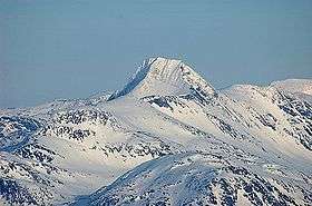
Neådalssnota is a mountain in the center of the Trollheimen mountain range. It lies in the municipality of Surnadal in Møre og Romsdal county, Norway. The mountain Snota lies just to the north, just next to the lake Gråsjøen.[1]
Neådalssnota, due to its large southeastern flank, is easily seen among the Trollheimen mountains.
References
- ↑ "Neådalssnota" (in Norwegian). yr.no. Retrieved 2010-12-07.
This article is issued from
Wikipedia.
The text is licensed under Creative Commons - Attribution - Sharealike.
Additional terms may apply for the media files.