Natoas Peak
| Natoas Peak | |
|---|---|
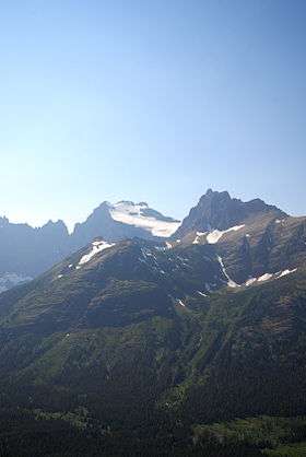 Natoas Peak is the rugged summit at right and snowy Mount Merritt is in the center | |
| Highest point | |
| Elevation | 9,476 ft (2,888 m) [1] |
| Prominence | 596 ft (182 m) [1] |
| Coordinates | 48°52′29″N 113°45′47″W / 48.87472°N 113.76306°WCoordinates: 48°52′29″N 113°45′47″W / 48.87472°N 113.76306°W [2] |
| Geography | |
 Natoas Peak | |
| Parent range | Lewis Range |
| Topo map | USGS Ahern Pass, MT |
| Climbing | |
| First ascent | Bruce Murphy and Bill Mathews, August 1964[1] |
Natoas Peak (9,476 feet (2,888 m)) is located in the Lewis Range, Glacier National Park in the U.S. state of Montana.[1] Natoas Peak is 1.10 miles (1.77 km) northeast of Mount Merritt.
First ascent by Bruce Murphy and Bill Mathews, August 1964.
See also
References
- 1 2 3 4 "Natoas Peak, Montana". Peakbagger.com. Retrieved 2010-07-03.
- ↑ "Natoas Peak". Geographic Names Information System. United States Geological Survey. Retrieved 2010-07-03.
This article is issued from
Wikipedia.
The text is licensed under Creative Commons - Attribution - Sharealike.
Additional terms may apply for the media files.