| [2] |
Name on the Register |
Image |
Date listed[3] |
Location |
City or town |
Description |
|---|
| 1 |
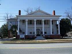
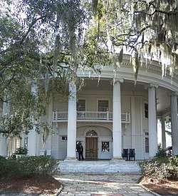
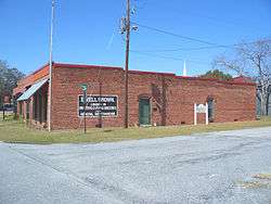
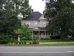
Barber-Pittman House |
|
February 12, 1980
(#80001108) |
416 N. Ashley St.
30°50′07″N 83°16′47″W / 30.835278°N 83.279722°W / 30.835278; -83.279722 (Barber-Pittman House) |
Valdosta |
|
| 2 |
Brookwood North Historic District |
|
June 2, 1995
(#95000684) |
Roughly bounded by Patterson St., Georgia Ave., Oak St., Park Ave., Williams St. and Brookwood Dr.
30°51′06″N 83°17′16″W / 30.851667°N 83.287778°W / 30.851667; -83.287778 (Brookwood North Historic District) |
Valdosta |
Contributing property at 1521 N Patterson St. |
| 3 |
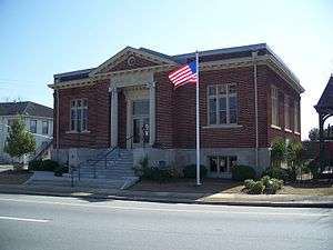
Carnegie Library of Valdosta |
|
January 12, 1984
(#84001120) |
305 W. Central Ave.
30°49′50″N 83°16′58″W / 30.830556°N 83.282778°W / 30.830556; -83.282778 (Carnegie Library of Valdosta) |
Valdosta |
Built in 1914, it now houses the Lowndes County Historical Society and Museum |
| 4 |
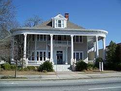
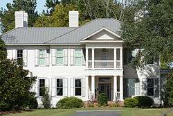
Converse-Dalton House |
|
April 28, 1983
(#83000233) |
305 N. Patterson St.
30°50′00″N 83°16′48″W / 30.8333°N 83.27988°W / 30.8333; -83.27988 (Converse-Dalton House) |
Valdosta |
|
| 5 |
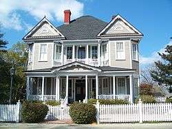
The Crescent |
|
January 8, 1980
(#80001109) |
904 N. Paterson St.
30°50′22″N 83°17′02″W / 30.839444°N 83.283889°W / 30.839444; -83.283889 (The Crescent) |
Valdosta |
|
| 6 |
Crestwood |
|
January 12, 1984
(#84001147) |
502 Eager Rd.
30°52′14″N 83°18′10″W / 30.87047°N 83.30272°W / 30.87047; -83.30272 (Crestwood) |
Valdosta |
Built in 1915, it is down a private gated drive, but visible from public property. |
| 7 |
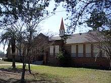
Dasher High School |
|
April 18, 1985
(#85000849) |
900 S. Troup St.
30°50′49″N 83°16′11″W / 30.846944°N 83.269722°W / 30.846944; -83.269722 (Dasher High School) |
Valdosta |
|
| 8 |
East End Historic District |
|
May 21, 2005
(#05000427) |
NE of downtown Valdosta roughly bounded by North Ashley and E. Ann Sts., East Hill Ave., and Georgia and Florida RR
30°50′19″N 83°16′25″W / 30.838611°N 83.273611°W / 30.838611; -83.273611 (East End Historic District) |
Valdosta |
Contributing property at 315 E Central Ave. |
| 9 |
Ewell Brown General Store |
|
February 21, 1997
(#97000099) |
RR Ave., jct. with Lawrence St.
30°40′59″N 83°10′56″W / 30.68319°N 83.18216°W / 30.68319; -83.18216 (Ewell Brown General Store) |
Lake Park |
Now houses the Lake Park Museum |
| 10 |
Fairview Historic District |
|
June 28, 1984
(#84001149) |
W. Central, Floyd, River, Varnedoe, and Wells Sts.
30°49′50″N 83°17′07″W / 30.830556°N 83.285278°W / 30.830556; -83.285278 (Fairview Historic District) |
Valdosta |
|
| 11 |
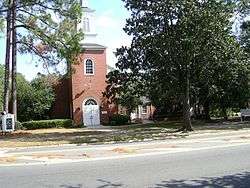
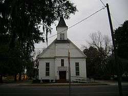
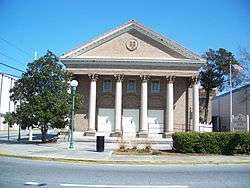
First Presbyterian Church |
|
November 2, 1987
(#87001912) |
313 N. Patterson St.
30°50′03″N 83°16′10″W / 30.834167°N 83.269444°W / 30.834167; -83.269444 (First Presbyterian Church) |
Valdosta |
|
| 12 |
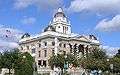
Lowndes County Courthouse |
|
September 18, 1980
(#80001110) |
Central and Ashley St.
30°49′57″N 83°16′45″W / 30.8325°N 83.279167°W / 30.8325; -83.279167 (Lowndes County Courthouse) |
Valdosta |
|
| 13 |
North Patterson Street Historic District |
|
June 28, 1984
(#84001151) |
1003-1111 N. Patterson St.
30°50′30″N 83°17′05″W / 30.841667°N 83.284722°W / 30.841667; -83.284722 (North Patterson Street Historic District) |
Valdosta |
|
| 14 |
Southside Historic District |
|
April 27, 2007
(#07000379) |
Roughly bounded by CSX tracks, Bunche Dr., Griffin Ave., Old Statenville Rd., Wisenbake Ln, Dasher Ln., and S. Patterson R
30°49′19″N 83°16′12″W / 30.822°N 83.270°W / 30.822; -83.270 (Southside Historic District) |
Valdosta |
|
| 15 |
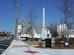
Sunset Hill Cemetery |
|
September 10, 2004
(#04000957) |
110 N. Oak St.
30°50′31″N 83°17′29″W / 30.841944°N 83.291389°W / 30.841944; -83.291389 (Sunset Hill Cemetery) |
Valdosta |
|
| 16 |
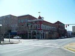
Valdosta Commercial Historic District |
|
September 15, 1983
(#83000234) |
Roughly bounded by Savannah Ave., Lee, Toombs, and Valley Sts.
30°49′53″N 83°16′43″W / 30.831389°N 83.278611°W / 30.831389; -83.278611 (Valdosta Commercial Historic District) |
Valdosta |
|