National Register of Historic Places listings in Lake County, Minnesota
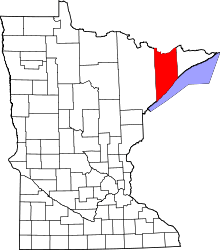
Location of Lake County in Minnesota
This is a list of the National Register of Historic Places listings in Lake County, Minnesota. It is intended to be a complete list of the properties and districts on the National Register of Historic Places in Lake County, Minnesota, United States. The locations of National Register properties and districts for which the latitude and longitude coordinates are included below, may be seen in an online map.
There are 21 properties and districts listed on the National Register in the county, including one National Historic Landmark.
- This National Park Service list is complete through NPS recent listings posted October 11, 2018.[1]
Current listings
| [2] | Name on the Register | Image | Date listed[3] | Location | City or town | Description |
|---|---|---|---|---|---|---|
| 1 | Benjamin Noble (Shipwreck) | 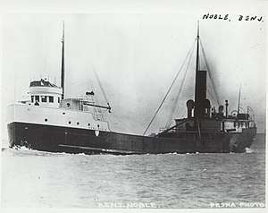 |
September 20, 2007 (#07000984) |
Mid-Lake off Knife River 46°56′00″N 91°40′00″W / 46.933333°N 91.666667°W |
Knife River vicinity | 1909 steel bulk freighter steamship, sank in 1914.[4] |
| 2 | Bridge No. 3589-Silver Creek Township | 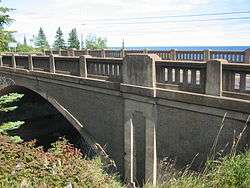 |
June 29, 1998 (#98000686) |
Minnesota State Highway 61 over the Stewart River 47°02′52″N 91°37′50″W / 47.047846°N 91.630687°W |
Silver Creek Township vicinity | 1924 reinforced concrete highway bridge noted for its unusually elaborate Neoclassical detailing in a rural setting, which was retained in a sympathetic 1939 widening.[5] |
| 3 | Duluth and Iron Range Railroad Company Depot | 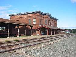 |
February 24, 1983 (#83000910) |
6th St. off South Ave. 47°01′08″N 91°40′12″W / 47.01879°N 91.670083°W |
Two Harbors | Large 1907 train station, symbolizing the key role of the Duluth and Iron Range Railroad in establishing Two Harbors as a link between northern Minnesota's iron and lumber fields and Lake Superior.[6] Now a museum.[7] |
| 4 | John Dwan Office Building | 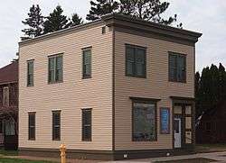 |
June 11, 1992 (#92000700) |
201 Waterfront Dr. 47°01′15″N 91°40′16″W / 47.020857°N 91.671229°W |
Two Harbors | 1898 office building associated with the early years of major international corporation 3M, being the site where the company was chartered in 1902 and headquartered from 1903 to 1916.[8] Now a museum.[9] |
| 5 | Edna G (tugboat) | 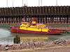 |
June 5, 1975 (#75002144) |
Home port at the southern end of Poplar St. in Agate Bay 47°01′01″N 91°40′21″W / 47.016831°N 91.672577°W |
Two Harbors | Tugboat in operation 1896–1981 to guide ore ships into harbor, nominated as a very long-serving Great Lakes vessel. Now a museum ship.[10][11] |
| 6 | Gooseberry Falls State Park CCC/WPA/Rustic Style Historic Resources | 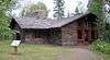 |
October 25, 1989 (#89001672) |
Off Minnesota State Highway 61 northeast of Two Harbors 47°08′29″N 91°27′33″W / 47.141362°N 91.459272°W |
Two Harbors vicinity | 88 park facilities built 1933–41, significant as examples of New Deal federal work relief, strategic recreational development around a scenic resource, and National Park Service rustic architecture (with especially fine masonry).[12] |
| 7 | Halfway Ranger Station | 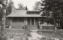 |
November 8, 2011 (#11000782) |
Minnesota State Highway 1 47°48′49″N 91°44′16″W / 47.813533°N 91.737817°W |
Fall Lake Township | Log Rustic Style administrative complex mostly built in the mid-1930s by the Civilian Conservation Corps for Superior National Forest. Now the Kawishiwi Field Laboratory.[13] |
| 8 | Harriet B.(shipwreck) | August 9, 2018 (#100002773) |
Address Restricted |
Two Harbors vicinity | ||
| 9 | Hesper Shipwreck Site |  |
April 14, 1994 (#94000343) |
Along the west breakwall in Silver Bay Harbor.[14] 47°16′17″N 91°16′18″W / 47.271389°N 91.271667°W |
Silver Bay vicinity | Well-preserved wreck of a bulk freight steamship, associated with the Great Lakes iron-ore and grain trades. Launched in 1890 and sunk in a 1905 spring storm.[15] |
| 10 | Isabella Ranger Station | 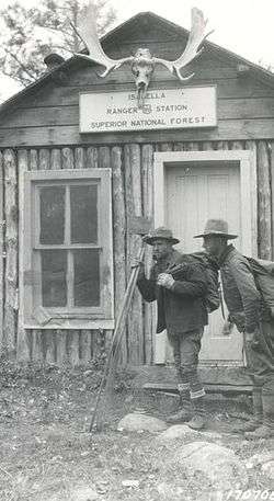 |
February 1, 2006 (#05001611) |
9420 Minnesota State Highway 1 47°37′06″N 91°22′39″W / 47.618433°N 91.377631°W |
Isabella vicinity | 1935 log Rustic Style residential complex built by the Civilian Conservation Corps for Superior National Forest workers.[16] |
| 11 | Lake County Courthouse and Sheriff's Residence |  |
February 24, 1983 (#83000912) |
601 3rd Ave. 47°01′20″N 91°40′17″W / 47.02209°N 91.671402°W |
Two Harbors | Queen Anne sheriff's residence/jail built circa 1887 and Beaux-Arts courthouse built in 1906, long-serving seats of Lake County government and representative examples of two eras of public architecture.[17] |
| 12 | Larsmont School | 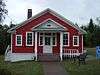 |
June 18, 1992 (#92000799) |
County Highway 61 46°58′52″N 91°44′39″W / 46.981083°N 91.744243°W |
Larsmont | 1914 school, focal point of a community formed in the early 20th century by immigrants from Finland's ethnic Swedish minority.[18] |
| 13 | Madeira (Schooner-Barge) Shipwreck | 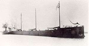 |
July 23, 1992 (#92000843) |
Near the base of Gold Rock[14] 47°12′22″N 91°21′29″W / 47.206111°N 91.358056°W |
Beaver Bay vicinity | Only known remains of a schooner-barge, a little-known ship type with sails to aid its tow vessel. Launched in 1900 and wrecked during the infamous Mataafa Storm of 1905, prompting construction of the Split Rock Lighthouse nearby.[19] |
| 14 | Edward and Lisa Mattson House and Fish House | 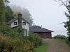 |
August 9, 1990 (#90001152) |
Off Minnesota State Highway 61 at the Beaver Bay shore near Wieland Island 47°16′02″N 91°16′57″W / 47.267119°N 91.282555°W |
East Beaver Bay | House dating to 1902 and fish house built circa 1930, two of the few surviving buildings associated with the small, family-owned outfits that pioneered commercial fishing on the North Shore.[20] |
| 15 | Niagara Shipwreck Site | 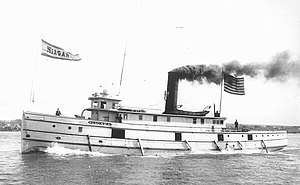 |
April 14, 1994 (#94000344) |
500 feet (150 m) south of Knife Island[14] 46°56′45″N 91°46′16″W / 46.945751°N 91.771245°W |
Knife River vicinity | Rare, early remnants of a class of large tugboats built for timber rafting on the Great Lakes. Launched in 1872 and sank in 1904 after running aground.[21] |
| 16 | Onoko (Bulk Freight Steamer) Shipwreck | 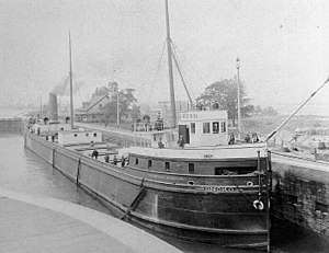 |
July 23, 1992 (#92000845) |
6 miles south Knife River 46°50′46″N 91°46′38″W / 46.8462°N 91.777333°W |
Knife River vicinity | 1882 iron-hulled steamship, prototype of the large Great Lakes bulk freighters that became critical to the steel industry. Sprang a leak and sank in 1915.[22] |
| 17 | Samuel P. Ely Shipwreck | 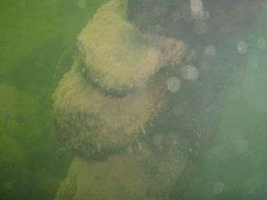 |
June 18, 1992 (#92000694) |
Along Two Harbors' west breakwall[14] 47°00′42″N 91°40′40″W / 47.011667°N 91.677778°W |
Two Harbors vicinity | Lake Superior's best remnant of the large ore schooners introduced around 1870, and a key part of local nautical lore for wrecking against the Two Harbors breakwater followed by the dramatic rescue of all hands in an 1896 storm.[23] |
| 18 | Split Rock Lighthouse | 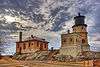 |
June 23, 1969 (#69000073) |
About 20 miles northeast of Two Harbors on Minnesota State Highway 61 47°12′00″N 91°22′01″W / 47.200072°N 91.366945°W |
Two Harbors vicinity | Clifftop lighthouse complex built 1909–10, significant for its association with the development of commercial shipping on the Great Lakes and the rare integrity of its 12 contributing properties. Now a museum. Declared a National Historic Landmark in 2011.[24] |
| 19 | Tettegouche Camp Historic District | January 17, 1989 (#88003084) |
Off County Highway 4 47°20′50″N 91°15′38″W / 47.347222°N 91.260556°W |
Silver Bay vicinity | Remote, private resort complex with 11 contributing properties mostly built 1910–1925, representative of northern Minnesota's early-20th-century resort industry and its Rustic architecture.[25] | |
| 20 | Two Harbors Carnegie Library | 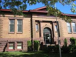 |
July 31, 1986 (#86002121) |
4th Ave. and Waterfront Dr. 47°01′21″N 91°40′15″W / 47.022522°N 91.670721°W |
Two Harbors | 1909 Carnegie library, home of a public institution founded in 1896 and Lake County's only public library until 1955. Also associated with a local construction boom and the work of Duluth architect Austin Terryberry.[26] |
| 21 | Two Harbors Light Station | 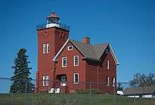 |
July 19, 1984 (#84001483) |
Agate and Burlington Bays 47°00′50″N 91°39′50″W / 47.013898°N 91.663935°W |
Two Harbors | 1892 lighthouse—oldest still operating on the North Shore—which made Two Harbors the initial primary Lake Superior ore port. Now a Lake County Historical Society museum and bed & breakfast.[27] |
See also
References
- ↑ "National Register of Historic Places: Weekly List Actions". National Park Service, United States Department of the Interior. Retrieved on October 11, 2018.
- ↑ Numbers represent an ordering by significant words. Various colorings, defined here, differentiate National Historic Landmarks and historic districts from other NRHP buildings, structures, sites or objects.
- ↑ The eight-digit number below each date is the number assigned to each location in the National Register Information System database, which can be viewed by clicking the number.
- ↑ "Benjamin Noble (shipwreck)". Minnesota National Register Properties Database. Minnesota Historical Society. Retrieved 2012-09-19.
- ↑ Hess, Jeffrey A. (September 1997). "National Register of Historic Places Registration Form: Bridge No. 3589". National Park Service. Retrieved 2017-03-11.
- ↑ Roth, Susan; Charles Nelson (1982-11-15). "National Register of Historic Places Inventory—Nomination Form: Duluth and Iron Range Railroad Company Depot". National Park Service. Retrieved 2017-03-11.
- ↑ "Depot Museum". Lake County Historical Society. Retrieved 2012-10-20.
- ↑ Roise, Charlene K. (1992-01-10). "National Register of Historic Places Registration Form: Dwan, John, Office Building". National Park Service. Retrieved 2017-03-11.
- ↑ "3M Museum". Lake County Historical Society. Retrieved 2012-09-19.
- ↑ Hackett, John J. (1975-03-11). "National Register of Historic Places Inventory -- Nomination Form: Edna G. (Tugboat)". National Park Service. Retrieved 2017-03-11.
- ↑ "Edna G. Tugboat". Lake County Historical Society. Retrieved 2012-09-19.
- ↑ Anderson, Rolf T. (1988-08-26). "National Register of Historic Places Registration Form: Gooseberry Falls State Park CCC/Rustic Style Historic District". National Park Service. Retrieved 2017-03-11.
- ↑ Ferguson, John (2009-10-28). "Halfway Ranger Station Historic District" (PDF). Heritage Stewardship Group, USDA Forest Service. Retrieved 2012-10-20.
- 1 2 3 4 Location given in Kohl, Cris (2001). The Great Lakes Diving Guide. West Chicago, Ill.: Seawolf Communications, Inc. NRIS lists site as "address restricted".
- ↑ "Hesper". Lake Superior Shipwrecks. Minnesota Historical Society. Retrieved 2012-08-28.
- ↑ "Isabella Ranger Station". Minnesota National Register Properties Database. Minnesota Historical Society. Retrieved 2012-09-19.
- ↑ Roth, Susan; Charles Nelson (1982-11-12). "National Register of Historic Places Inventory—Nomination Form: Lake County Courthouse and Sheriff's Residence". National Park Service. Retrieved 2017-03-05.
- ↑ Anderson, David C. (1991-09-18). "National Register of Historic Places Registration Form: Larsmont School". National Park Service. Retrieved 2017-03-05.
- ↑ "Madeira". Lake Superior Shipwrecks. Minnesota Historical Society. Retrieved 2017-03-05.
- ↑ Koop, Michael (January 1990). "National Register of Historic Places Registration Form: Mattson, Edward and Lisa, House and Fish House". National Park Service. Retrieved 2017-03-05.
- ↑ "Niagara". Lake Superior Shipwrecks. Minnesota Historical Society. Retrieved 2017-03-05.
- ↑ "Onoko". Lake Superior Shipwrecks. Minnesota Historical Society. Retrieved 2017-03-05.
- ↑ "Samuel P. Ely". Lake Superior Shipwrecks. Minnesota Historical Society. Retrieved 2017-02-11.
- ↑ Faltinson, Brian J. (2008-08-05). "National Historic Landmark Nomination: Split Rock Light Station" (PDF). National Park Service. Retrieved 2017-02-05.
- ↑ Koop, Michael (June 1988). "National Register of Historic Places Registration Form: Tettegouche Camp Historic District". National Park Service. Retrieved 2017-02-05.
- ↑ Holum, Liz (December 1984). "National Register of Historic Places Inventory—Nomination Form: Two Harbors Carnegie Library". National Park Service. Retrieved 2017-02-05.
- ↑ "Two Harbors Light Station". Lake County Historical Society. Retrieved 2012-10-20.
External links
| Wikimedia Commons has media related to National Register of Historic Places in Lake County, Minnesota. |
- Minnesota National Register Properties Database—Minnesota Historical Society


This article is issued from
Wikipedia.
The text is licensed under Creative Commons - Attribution - Sharealike.
Additional terms may apply for the media files.