National Highway 1 (Djibouti)
| National Highway 1 | |
|---|---|
| Highway system | |
| Transport in Djibouti |
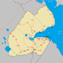
Map of Djibouti national highway
National Highway 1 is a major national highway of Djibouti. It connects the suburbs of Djibouti City to Yoboki and the Ethiopian border near Galafi, where it becomes Ethiopia's National Highway 18. The highway begins at a roundabout in Djibouti City at 11°34′4″N 43°7′50″E / 11.56778°N 43.13056°E, near Colege De Fukuzawa, where it connects with National Highway 2 and National Highway 3. National Highway 1 is 255 km (159 mi) in length and passes through the regions of Djibouti Region, Arta Region, Ali Sabieh Region and Dikhil Region.
The highway is heavily traveled by Ethiopian trucks.[1]
References
- ↑ "Traffic and Road Conditions in Djibouti". Country Reports. Retrieved February 3, 2018.
This article is issued from
Wikipedia.
The text is licensed under Creative Commons - Attribution - Sharealike.
Additional terms may apply for the media files.