Nassandres
| Nassandres | ||
|---|---|---|
 | ||
| ||
 Nassandres Location within Normandy region  Nassandres | ||
| Coordinates: 49°07′39″N 0°44′08″E / 49.1275°N 0.7356°ECoordinates: 49°07′39″N 0°44′08″E / 49.1275°N 0.7356°E | ||
| Country | France | |
| Region | Normandy | |
| Department | Eure | |
| Arrondissement | Bernay | |
| Canton | Brionne | |
| Area1 | 4.92 km2 (1.90 sq mi) | |
| Population (2008)2 | 1,392 | |
| • Density | 280/km2 (730/sq mi) | |
| Time zone | UTC+1 (CET) | |
| • Summer (DST) | UTC+2 (CEST) | |
| INSEE/Postal code | 27425 /27550 | |
| Elevation |
63–149 m (207–489 ft) (avg. 80 m or 260 ft) | |
|
1 French Land Register data, which excludes lakes, ponds, glaciers > 1 km2 (0.386 sq mi or 247 acres) and river estuaries. 2 Population without double counting: residents of multiple communes (e.g., students and military personnel) only counted once. | ||
.svg.png)
Nassandres is a former commune in the Eure department in Normandy in northern France. On 1 January 2017, it was merged into the new commune Nassandres sur Risle.[1]
Population
| Historical population | ||
|---|---|---|
| Year | Pop. | ±% |
| 1962 | 1,233 | — |
| 1968 | 1,307 | +6.0% |
| 1975 | 1,331 | +1.8% |
| 1982 | 1,417 | +6.5% |
| 1990 | 1,350 | −4.7% |
| 1999 | 1,381 | +2.3% |
| 2008 | 1,392 | +0.8% |
Sights
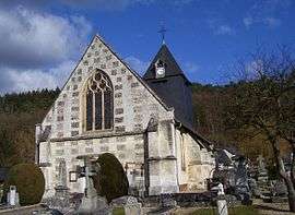
The church of Saint-André was built in the 12th century and enlarged in the 16th century. The sacristy was built in the 17th century.
See also
References
- ↑ Arrêté préfectoral 3 August 2016 (in French)
External links
| Wikimedia Commons has media related to Nassandres. |
- Nassandres on les communes de France (French)
- Nassandres
- official site (French)
This article is issued from
Wikipedia.
The text is licensed under Creative Commons - Attribution - Sharealike.
Additional terms may apply for the media files.