Narikkuni
| Narikkuni | |
|---|---|
| Village | |
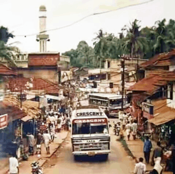 A view of Narikkuni town from the Koduvally road junction in the 90s. [2] | |
 Narikkuni Location in Kerala, India  Narikkuni Narikkuni (India) | |
| Coordinates: 11°21′57″N 75°51′49″E / 11.3658°N 75.8636°ECoordinates: 11°21′57″N 75°51′49″E / 11.3658°N 75.8636°E | |
| Country |
|
| State | Kerala |
| District | Kozhikode |
| Government | |
| • Type | Grama Panchayat |
| • Panchayat President | P. K. Vabitha (Left Democratic Front) |
| • Member of Legislative Assembly | Karat Razak (Independent-Left Democratic Front) |
| • Member of Parliament | M. K. Raghavan (United Democratic Front) |
| Area | |
| • Total | 17.85 km2 (6.89 sq mi) |
| Elevation | 35 m (115 ft) |
| Population (2011) | |
| • Total | 24,290 |
| • Density | 1,400/km2 (3,500/sq mi) |
| Languages | |
| • Official | Malayalam, |
| Time zone | UTC+5:30 (IST) |
| PIN | 673585 |
| Telephone code | 0495 |
| Vehicle registration | KL 57 |
| Nearest city | Kozhikode |
Narikkuni ([n̪ʌɾɪkkʊnɪ]) is a town in Kozhikode district in the state of Kerala, India. According to Census 2011 information the location code or village code of Narikkuni town is 627402. Narikkuni town is located in Kozhikode Tehsil of Kozhikode district in Kerala, India. It is situated 20km away from Kozhikode, which is both the district & the sub-district headquarters of Narikkuni village.
The total geographical area of the village is 1785 hectares. Narikkuni has a total population of 24,290 and about 5,785 houses. Kozhikode is nearest town to Narikkuni which is approximately 20km away.[3]
Location and Connectivity
Narikkuni is located at a distance of about 20km from Kozhikode, the district headquarters, and is well connected by road to the nearby towns. There are five main roads that span out from the Narikkuni city centre. Kozhikode is accessible by two routes, via the Narikkuni-Padanilam road[4] (which spans 5.1km and joins NH 766 at Padanilam) and the Kumaraswami Raja road[5]. Narikkuni-Koduvally road is a 6.6km stretch of road connects Narikkuni to NH 766 at Koduvally[6]. Poonoor is about 10km away and can be reached by the Narikkuni-Poonoor road. The fifth road, the 8.3km long Narikkuni-Nanminda road[7], leads to Nanminda and beyond. The town has a bus stand-cum-shopping complex and acts as the origin to the bus services to all the main surrounding places.
Administration
Narikkuni village is administrated by Sarpanch (Panchayat President, or in other words, Head of the Village) who is the elected representative of the village. The panchayat Elections in 2015 saw the Left Democratic Front winning 9 out of the 15 seats to secure majority. The United Democratic Front emerged victorious in the remaining 6 seats. The Panchayat is currently headed by P. K. Vabitha of LDF.
| Sl No. | Ward | Representative | Affiliation |
|---|---|---|---|
| 1 | Kundayi | Beena Kalarikkal | UDF |
| 2 | Pannikkottoor | Nisha Chandran | UDF |
| 3 | Moorkhan Kundu | Randamkunnuchalil Mariya | LDF |
| 4 | Karukulangara | Venugopal C. | LDF |
| 5 | Vattapparappoyil | Vasanthakumari | LDF |
| 6 | Narikkuni | V. Illyas | UDF |
| 7 | Parannur | Fousiya Rahman | UDF |
| 8 | Palolithazham | Abdul Jabbar | LDF |
| 9 | Kalkkudumby | Vasanthakumari | LDF |
| 10 | Chengottu Poyil | Amina I. | LDF |
| 11 | Nellyerithazham | P. I. Vasudevan Namboothiri | UDF |
| 12 | Odupara | P. K. Vabitha (President) | LDF |
| 13 | Kavum Poyil | Girija Chandrasekharan | LDF |
| 14 | Kalathil Para | Shiji Ottupurakkandi | LDF |
| 15 | Kodoli | Fazal Muhammed | UDF |
Important Landmarks
- Government Higher Secondary School, Narikkuni
- Kuttamboor Higher Secondary school, Punnassery(PO)Narikkuni
- Narikkuni AUP School
- Community Health Centre, Narikkuni
- Naikkuni Bus Stand
- State Bank of India, Narikkuni
- Kerala Gramin Bank, Narikkuni
- Narikkuni KDC Bank
- Narikkuni Service Sahakarana Bank
- Narikkuni Fish Market and Slaughter House Complex
- Madavoor CM Makham
- Thavanoor Sri Vishnu Temple, Punnassery
- Sri Gurudeva Temple, Punnassery
- Kadambur Temple, Karakkunnath
- Thali Maha Temple, Nanmanda
- Ayyarvattom Maha Sudarshana Temple, Eravannur (The only sudarshana temple in Kerala)
- Parannur Mahadeva Temple,Parannur
- parannur Juma Mashid
- Vadekkandi thazham Juma Masjid
Suburbs and Villages
- Punnassery
- Karakkunnath
- Parannur
- Koolippoyil
- Vadekkandithazham
- Ambalappoyil
- Nanminda
- Eravannur
- Madavoor
- Palangad
Notable persons
- Surabhi Lakshmi, actress[8]
- santhosh pandith Read more
References
- ↑ https://villageinfo.in/kerala/kozhikode/kozhikode/narikkuni.html
- ↑ https://villageinfo.in/kerala/kozhikode/kozhikode/narikkuni.html
- ↑ India, Registrar General & Census Commissioner (2011). "Census of India : Villages with population 5000 & above". Retrieved 2008-12-10.
- ↑ "Narikkuni - Padanilam Road, Kerala, Kozhikode, Paimpalasseri CM Makham". streets.openalfa.in. Retrieved 2018-03-01.
- ↑ "Google Maps". Google Maps. Retrieved 2018-03-01.
- ↑ "Narikkuni - Madavoor - Koduvally road, Kerala, Kozhikode, Koduvally". streets.openalfa.in. Retrieved 2018-03-01.
- ↑ "Narikkuni - Padanilam Road, Kerala, Kozhikode, Paimpalasseri CM Makham". streets.openalfa.in. Retrieved 2018-03-01.
- ↑ Faruque, Shameem (1 July 2013). "The Scent Of Acting". www.yentha.com. Retrieved 2 April 2018.
| Wikimedia Commons has media related to Balussery. |