Narawntapu National Park
| Narawntapu National Park Tasmania | |
|---|---|
|
IUCN category II (national park) | |
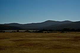 Narawntapu National Park, December 2009 | |
| Nearest town or city | Port Sorell |
| Coordinates | 41°07′58″S 146°39′24″E / 41.13278°S 146.65667°ECoordinates: 41°07′58″S 146°39′24″E / 41.13278°S 146.65667°E |
| Established | 1976 |
| Area | 43.49 km2 (16.8 sq mi) |
| Visitation | 10,100 (in 1996/97)[1] |
| Managing authorities | Tasmania Parks and Wildlife Service |
| Website | Narawntapu National Park |
| See also | Protected areas of Tasmania |
Narawntapu (formerly known as "Asbestos Range") is a national park in Tasmania, Australia. It lies on Tasmania's north coast, adjoining Bass Strait, between Port Sorell in the west and the mouth of the Tamar River in the east. It lies about 20 km east of Devonport, 60 km north-west of Launceston and 250 km north of Hobart.
Narawntapu encompasses islands in the Port Sorell estuary and the Carbuncle, as well as land extending to low water mark, including intertidal mudflats. The highest point of the park is 392 m ASL. It is listed on Australia's Register of the National Estate.[1]
Because of its proximity to the tourist centres of Devonport and Port Sorell, Narawntapu is popular with visitors. It has been referred to as "Tasmania's Serengeti", owing to the abundance of wildlife in the Springlawn area of the park, the main access point for visitors.
History
The park was originally reserved, as the Asbestos Range National Park, on 29 June 1976. The name was changed to Narawntapu in 2000 because of concerns that the word 'Asbestos' was deterring potential visitors. 'Narawntapu' is of Tasmanian Aboriginal origin, referring to the coastal promontories West Head and Badger Head within the park.[1]
Climate
Narawntapu has a temperate maritime climate with an annual, mainly winter, rainfall of 750 mm. The prevailing winds are from the north-east and north-west. Mean temperatures are 17°C in January and 9°C in July.[1]
Flora and fauna
Vegetation communities represented in the park include coastal heathland, dry sclerophyll woodland, herbland, grassland and salt marsh. The rare Pygmy Clubmoss has been recorded from the park.
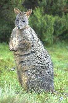
A feature of the park is the high density of marsupials present, including eastern grey kangaroos, Bennett's wallabies, Tasmanian pademelons, common wombats and Tasmanian devils. eastern and spotted-tail quolls are also found there as well as platypuses and echidnas. The birdlife is rich and includes threatened species such as the hooded plover, Tasmanian wedge-tailed eagle and swift parrot. The intertidal mudflats in the North East Arm area of the park are an important foraging area for migratory waders,[1] and form part of the Rubicon Estuary Important Bird Area, identified as such by BirdLife International bercause of their importance for pied oystercatchers.[2]
See also
References
- 1 2 3 4 5 Anon. (2000). Narawntapu National Park, Hawley Nature Reserve - Management Plan 2000. Parks and Wildlife Service, Tasmania. ISBN 0-7246-2122-9 "Archived copy" (PDF). Archived from the original (PDF) on 22 July 2008. Retrieved 21 July 2008. PDF download
- ↑ "IBA: Rubicon Estuary". Birdata. Birds Australia. Retrieved 2011-09-01.
External links
| Wikimedia Commons has media related to Narawntapu National Park. |