Nanukamachi Station
Nanukamachi Station 七日町駅 | |
|---|---|
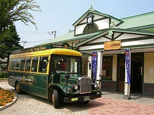 Nanukamachi station and "Haikara-san" | |
| Location |
5-1 Nanukamachi, Aizuwakamatsu, Fukushima (福島県会津若松市七日町5-1) Japan |
| Operated by | |
| Line(s) | |
| History | |
| Opened | 1934 |
Nanukamachi Station (七日町駅 Nanukamachi-eki) is a railway station on the Tadami Line in Aizuwakamatsu, Fukushima Prefecture, Japan, operated by East Japan Railway Company (JR East). Nanukamachi is "七日町" in Japanese. It means that bazaar was held on the seventh day in Edo era. "七日町" is also called "Nanokamachi".
Lines
Nanukamachi Station is served by the Tadami Line, and is located 1.3 rail kilometers from the official starting point of the line at Aizu-Wakamatsu Station. It is also served by the Aizu Railway Aizu Line.
Station layout
Nanukamachi Station has a single side platform serving traffic in both directions. Nanokamachi Station, there is the "EkiCafe.". It is a shop that sells many things of Aizu region, such as traditional sweets. And it also has an information corner about sightseeing in Aizu.[1] The bus for sightseeing of Aizuwakamatsu stops at Nanukamachi station. It calls "Haikara-san".
Adjacent stations
| « | Service | » | ||
|---|---|---|---|---|
| Tadami Line | ||||
| Aizu-Wakamatsu | - | Nishi-Wakamatsu | ||
| Aizu Railway Aizu Line | ||||
| Aizu-Wakamatsu | - | Nishi-Wakamatsu | ||
History
Nanukamachi Station opened on November 1, 1934. Operations were suspended from June 20 1945 to June 20 1946. The station was absorbed into the JR East network upon the privatization of the Japanese National Railways (JNR) on April 1, 1987. A new station building was completed July 28, 2002.
Surrounding area
- Amida Temple
- Aizuwakamatsu city hall
- Aizuwakamatsu post office
- Wakamatsu-Nanukamachi post office
- Nisshin Elementary School
- Aoi Senior High School
- Aizuwakamatsu Xaverio Gakuen
- Elementary School
- Junior High School
- Senior High School
- Japan National Route 118
- Japan National Route 252
- Fukushima Prefectural Route 59
- Fukushima Prefectural Route 325
- Fukushima Prefectural Route 326
References
External links
| Wikimedia Commons has media related to Nanukamachi Station. |
- JR East Station information (in Japanese)
- Aizu Railway Station information (in Japanese)
- Nanukamachi Street information (in Japanese)
Coordinates: 37°30′4.2″N 139°55′8.4″E / 37.501167°N 139.919000°E