Nantlle Railway
 Horse-drawn slate wagon used on the Tramway, now preserved at the Welsh Slate Museum, Llanberis | |
| Locale | Wales |
|---|---|
| Dates of operation | 1828–1865 |
| Successor | Carnarvonshire Railway |
| Track gauge | 3 ft 6 in (1,067 mm) and 4 ft 8 1⁄2 in (1,435 mm) |
| Headquarters | Penygroes |
| Nantlle Railway | |||||||||||||||||||||||||||||||||||||||||||||||||||||||||||||||||||||||||||||||||||||||||||||||||||||||||||||||||||||||||||||||||||||||
|---|---|---|---|---|---|---|---|---|---|---|---|---|---|---|---|---|---|---|---|---|---|---|---|---|---|---|---|---|---|---|---|---|---|---|---|---|---|---|---|---|---|---|---|---|---|---|---|---|---|---|---|---|---|---|---|---|---|---|---|---|---|---|---|---|---|---|---|---|---|---|---|---|---|---|---|---|---|---|---|---|---|---|---|---|---|---|---|---|---|---|---|---|---|---|---|---|---|---|---|---|---|---|---|---|---|---|---|---|---|---|---|---|---|---|---|---|---|---|---|---|---|---|---|---|---|---|---|---|---|---|---|---|---|---|---|
| |||||||||||||||||||||||||||||||||||||||||||||||||||||||||||||||||||||||||||||||||||||||||||||||||||||||||||||||||||||||||||||||||||||||
The Nantlle Railway (sometimes referred to as the Nantlle Tramway) was a Welsh narrow gauge railway. It was originally built to carry slate from several slate quarries across the Nantlle Valley to the harbour at Caernarfon for export by sea. The line also provided a passenger service between Caernarfon and Talysarn from 1856 to 1865. It holds the distinction of being the first public railway to be operated in North Wales.[1]
First proposed during the 1810s in response to the needs of local industry, the Nantlle Railway received its authorising Act of Parliament during May 1825, leading to the incorporation of a company and construction activity thereafter. The line itself was designed and constructed by the noted railway pioneer George Stephenson and his brother, Robert Stephenson.[2] The line was opened in 1828 and was operated using horse power. While use of the route by passenger services did not prove to be popular, thus these were operated for less than a decade, it did function as a valued medium for freight traffic from the mines.
During the 1860s and 1870s, significant portions of the route were replaced by standard gauge tracks; this work was largely by the London and North Western Railway (LNWR), who had acquired the line during the late 1860s. The Nantlle Railway was closed during 1963 by the nationalised operator British Railways (BR), the Nantlle Railway was the final line to be operated by BR that made use of horse traction. In the present day, most of the route has been overlaid with later track or obliterated by other later developments, however several of the former railway's structures do remain. Furthermore, two miles of the northern section of the original Nantlle Railway trackbed, between Dinas and the Afon Seiont, now forms part of the reopened Welsh Highland Railway.
History
Background
It is believed that the first proposals for the construction of a railway in the Nantlle Valley were made during 1813.[1] In this era, slate, which was quarried at sites to both the north and west of Nantlle, was a highly lucrative and sought-after material; accordingly, a viable means of expediting its shipping was therefore considered to be quite worthwhile. By constructing a railway between the harbour at Caernarfon and the quarries, the otherwise-necessary slow and costly road journeys could be eliminated and the local industry could better compete with rivals, such as the sizable operations at Dinorwic and Penrhyn.[1]
Following an evaluation of alternatives, a preferred 14.5km route for the envisioned line was surveyed; this meandered westwards from various branches that linked with the existing Nantlle quarries, towards the villages of Talysarn and Penygroes, after which the line turned northwards, passing through the communities of Groeslon, Llanwnda, Dinas and Bontnewydd.[1] In addition to slate traffic, the line was also developed to support copper mining activity at Drws-y-coed, to the east of Nantlle. While several private tramways had been established at individual quarries and collieries across Britain, this line would become the first purpose-built public line for the quarrying industry. In terms of its operation, the line was effectively run like a toll road would be, in that customers were charged a fee in exchange for the haulage of goods.[1]
On 20 May 1825, an authorising Act for the proposed Nantlle Railway was passed by Parliament; shortly thereafter, the ‘’Nantlle Railway Company’’ was incorporated for the purpose of constructing and operating the authorised railway.[1] The company quickly raised a working capital of £20,000 via the issuing of shares at a value of £100 each.[1] The majority of the railway’s shareholders comprised the owners of the same local quarries that stood to benefit from the line’s completion. The chief engineer of the Nantlle Railway Company was the railway pioneer George Stephenson, while the line’s construction was overseen by his brother Robert Stephenson, who was assisted in this capacity by John Gillespie.[1]
Construction
During the construction of the Nantlle Railway, a further two related Acts were passed. On 21 March 1827, a second Act, which authorised the raising of an additional £70,000 to finance construction activity by mortgaging the line’s works and enacted restrictions upon the line’s future tonnage duties; these limitations would expire upon the repayment of all debts.[1] On 23 May 1828, in response to the slower than expected rate of progress, a third Act was issued that permitted five additional years in which the construction work was to be finished within. Robert Williams of Bangor was appointed as the resident engineer while William Owen of Gwaenfynydd, Anglesey was contracted to perform the line’s construction.[1]
In order to complete the railway, several civil engineering works had to be built along its route, including a 120 meter-long embankment and culvert to the west of Bontnewydd, a pair of tunnels, and a single bridge.[1] The Coed Helen Tunnel was constructed to carry the line underneath an existing road. It was a short structure with a relatively gentle gradient, rising from north to south, both the walls and roof of the tunnel were composed of coursed blocks, some being up to 1.3 meters long.[1] The Plas Dinas Tunnel enabled the line to cross underneath the driveway of Plas Dinas house. Possessing a length of 45.1 meters and a width of 2.45 meters, it has a semi-circular arched roof with a height of 1.75 meters, comprising three rings of brick, supported by walls of stone rubble. The Plas Dinas Tunnel is approached by a pair of cuttings; these have a maximum depth of 10.8m deep.[1]
The Afon Gwyrfai Bridge is a single arch structure which carried the railway over the Afon Gwyrfai to the west of Bontnewydd.[1] It possesses a width of 6.15 meters at its base, which narrows somewhat towards the crown, while the arch has a span of 15.3 meters between the approach embankments and an approximate height of 5.6 meters above the water level. It is principally composed out of rusticated stone blocks. During September 1999, the Afon Gwyrfai Bridge was recognised as being a Grade II listed structure.[1]
The original track of the line was relatively lightweight wrought iron fish-bellied rails; these were eventually replaced over time by more modern flat-bottomed rails instead.[1] It was constructed to a gauge of 1.067 meters (3 foot, 6 inches), which had been allegedly chosen by company officials in spite of Stephenson’s personal dismay for such a selection. The selected gauge was significantly wider than the commonly-used 610mm (2 foot) gauge found on contemporary quarry tramroads, but was narrower than the 1.435 meter (4 foot, 8.5 inches) which would soon become the standard gauge used through Britain’s extensive railway network, ironically achieved as a result of the prolific work undertaken on many other projects by George Stephenson.[1]
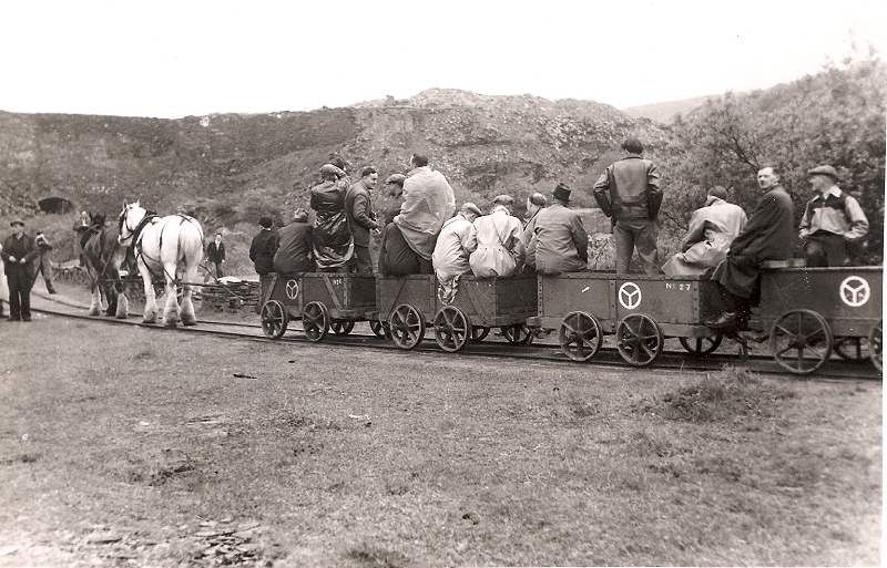
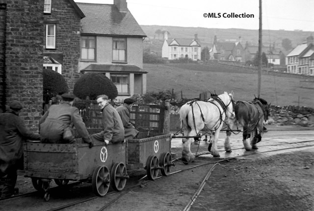
The Nantlle Railway featured a single track, being furnished with 22 passing points but without any use of signalling or other traffic control systems.[1] Operationally, trains would progress from one passing place to the next via line of sight alone; this would often led to disputes and arguments breaking out when opposing trains would meet between passing spaces. Each train would typically consist of either four or five wagons, which were pulled by a single horse that would travel at the walking pace of the person leading the horse, this being roughly 3.2-4.8kph (2-3mph).[1]
Ownership changes and later use
During 1865, the Nantlle Railway was absorbed into the Carnarvonshire Railway which, in turn, was acquired by the London and North Western Railway (LNWR) in July 1870.[1] The central part of its route, from Pant, on the southern edge of Caernarfon to Tyddyn Bengam, a short distance north of Penygroes, was rebuilt during 1867, in places on an adjacent alignment, to single track standard gauge main line standards to allow the operation of the Carnarvonshire Railway's steam-hauled trains through to Afon Wen.[1]
This left 3 ft 6 in (1,067 mm) gauge sections at both northern and southern ends of the line, with five miles of standard gauge in the middle. Slates were loaded onto narrow gauge wagons near the quarries and drawn by horses to Tyddyn Bengam, where the narrow gauge wagons and their contents were pushed onto standard gauge wagons, three at a time. A train of these piggy-back wagons was made up and hauled by a locomotive north to Pant, where the narrow gauge wagons and contents were pushed off the standard gauge wagons onto narrow gauge tracks and hauled by horses along the last 50 chains (1.0 km) to the quayside at Caernarfon Harbour. This process was slow, costly and unpopular; it also led to instances of pilfering and breakages.
During 1870, the LNWR, who had taken over both the narrow and standard gauge routes by this point, decided to extend the standard gauge line northwards past the edge of the harbour estate to Caernarvon, thereby linking to Bangor and the rest of the UK. Shortly afterwards, a branch was opened, extending initially to St Helens Road, just into the harbour estate. This moved the northern transshipment process nearer the water's edge, but it continued all the same. Within a couple of years, the standard gauge tracks were extended to the quayside, obliterating the narrow gauge infrastructure north of the Afon Seiont and permanently removing the need for transhipment in the town.
.jpg)
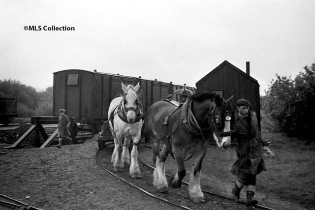
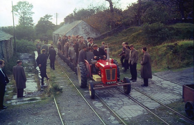
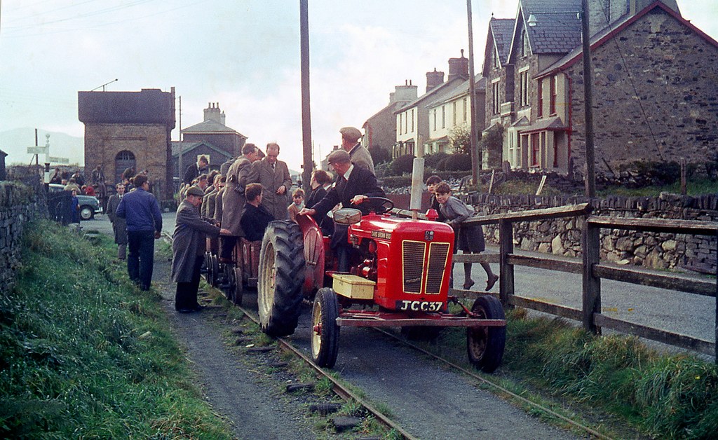
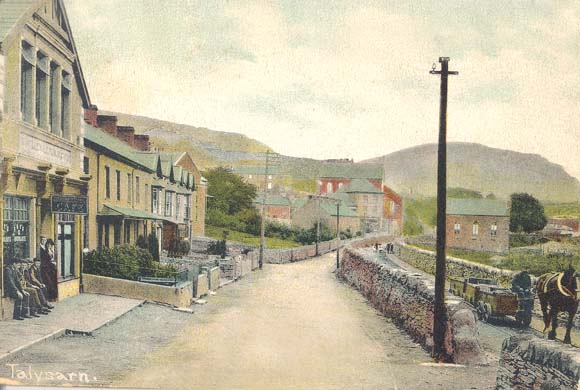
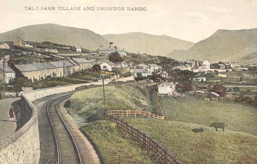
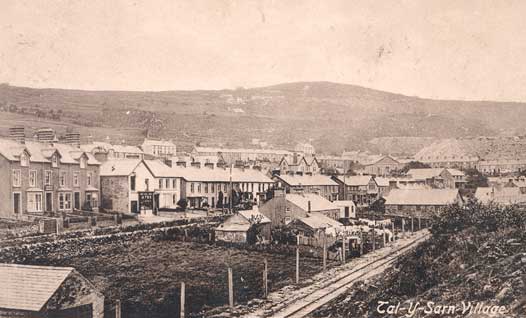
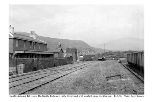
In 1872, the LNWR built a standard gauge line at the southern end of the route from Penygroes to a new station at Talysarn, which, confusingly, they named Nantlle. This was built partly on new ground and partly over narrow gauge infrastructure.[1] Extensive transshipment yards were laid out at 'Nantlle'. Thereafter, narrow gauge wagons arrived from the quarries, their contents (not the wagons and contents) were transhipped onto standard gauge wagons[3] to be taken to the quays at Caernarfon or to anywhere else the LNWR served. This left a couple of miles of 3 ft 6in gauge, horse-drawn tramway linking 'Nantlle' (Talysarn) with several quarries.[1] This remnant was operated as such by the LNWR, then from 1923 by the London Midland and Scottish Railway (LMS) and from 1948 until 1963 by the nationalised British Railways (BR) as far as the Pen-yr-Orsedd Quarry.[4] It is the last recorded use of horses by BR, and closed only with the closure of the branch line to which it connected.
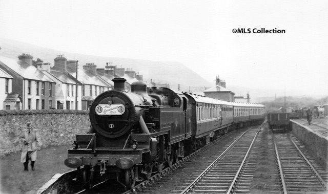
In its closing years, the line attracted a number of enthusiasts' railtours.[5] Conversely, when the Ffestiniog Railway celebrated its centenary on 22 May 1963, a Nantlle horse and handler hauled a demonstration train at Porthmadog.[6] Two miles of the northern section of the original Nantlle Railway trackbed, between Dinas and the Afon Seiont, now forms part of the reopened Welsh Highland Railway.
Rolling stock
The narrow gauge line was a form of wagonway constructed to a gauge of 3 ft 6 in (1,067 mm) and equipped with four wheeled wagons fitted with double-flanged wheels,[7][8] which were loose on fixed axles. For many of their later years many wagons had extended axles which protruded beyond the wheels.[9] Some wagons had eyes bolted to the tops of their sides to enable them to be lifted bodily by the Blondins used in some of the quarries.[10][11] The wagons were owned by the tramway, rather than the quarries and the many that survived into BR ownership had narrow steel plate bodies, which were mounted between the wheels and bolted to the axles. Their shape and structure appears to have changed little from the railway's earliest years.
_(14782278234).jpg)
.jpg)
Modern times
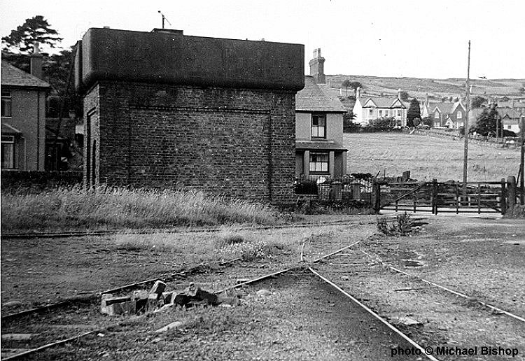
Most of the route has been overlaid with later track or obliterated by later developments, but in 2016 the remains of three significant Nantlle Railway structures could still be found:
- a tunnel at Coed Helen, just visible from passing Welsh Highland Railway trains[12][13]
- a bridge near Bontnewydd[14][15]
- a tunnel at Plas Dinas[16]
Gallery
- "Nantlle quarries and tramway". digiDo.
- "Nantlle Railway horses at work". digiDo.
- "Nantlle's working horses". Robinson Maps.
- "Near Nantlle station 1961". Penmorfa.
- "An enthusiasts' railtour 5 May 1957". BBC.
- "An enthusiasts' railtour 5 May 1957". Manchester Locomotive Society.
- "An enthusiasts' railtour 5 May 1957". J.W. Sutherland.
- "An enthusiasts' railtour". Manchester Locomotive Society.
- "An enthusiasts' railtour". Manchester Locomotive Society.
- "An enthusiasts' railtour 20 Oct 1963". flickr.
- "An enthusiasts' railtour 20 Oct 1963". flickr.
- "An enthusiasts' railtour 20 Oct 1963". Six Bells Junction.
- "Nantlle Railway Crest". Welsh Highland Heritage.
- "Near Nantlle station". Penmorfa.
- "Nantlle station after closure". NW Rail.
- "Railways at Talysarn". Nantlle Valley History.
- "Railways at Talysarn". Nantlle Valley History.
- "Railways at Talysarn". Nantlle Valley History.
- "Dorothea Quarry Blondins". Penmorfa.
- "Dorothea Quarry Blondins". Penmorfa.
- "Dorothea Quarry Blondins". Wikimedia.
- "Dorothea Quarry Blondins". Penmorfa.
- "Nantlle slate transfer wharf". Narrow Gauge Heaven.
- "Nantlle slate transfer wharf". flickr.
- "Nantlle Railway". flickr.
See also
References
- 1 2 3 4 5 6 7 8 9 10 11 12 13 14 15 16 17 18 19 20 21 22 23 “Nantlle Railway, site of.” ‘’engineering-timelines.com’’, Retrieved: 28 June 2018.
- ↑ Boyd 1990, p. 15.
- ↑ Anon 2011, p. 306.
- ↑ Mitchell & Smith 2010, Photo 58.
- ↑ "Railtour at Nantlle". BBC.
- ↑ Stretton 1999, p. 73.
- ↑ Hatherill & Hatherill 2009, pp. 7 & 45.
- ↑ Messenger 2008, pp. 25-9 & 32-5.
- ↑ Green 1996, p. 92.
- ↑ "Bondins at Pen-yr-Orsedd Quarry". Penmorfa.
- ↑ "Bondins at Pen-yr-Orsedd Quarry". Yooniq Images.
- ↑ "Coed Helen tunnel remains". Welsh Highland Heritage.
- ↑ Baxter 1966, p. 140.
- ↑ "Bontnewydd bridge remains". Welsh Highland Heritage.
- ↑ Baxter 1966, p. 127.
- ↑ "Plas Dinas tunnel remains". Welsh Highland Heritage.
Sources
- Anon (May 2011). Smith, Martin, ed. "The Nantlle Tramway". Railway Bylines. Radstock: Irwell Press Limited. 16 (6). ISSN 1360-2098.
- Baxter, Bertram (1966). Stone Blocks and Iron Rails. Newton Abbot: David and Charles. ISBN 978-0-7153-4004-2. OCLC 643482298.
- Boyd, James I.C. (1990) [1972]. Narrow Gauge Railways in North Caernarvonshire, Volume 1: The West. Headington: The Oakwood Press. ISBN 978-0-85361-273-5. OCLC 650247345.
- Green, C.C. (1996) [1983]. North Wales Branch Line Album. Shepperton: Ian Allan Publishing. ISBN 978-0-7110-1252-3.
- Hatherill, Gordon; Hatherill, Ann (2009). Slate Quarry Album. Garndolbenmaen: RCL Publications. ISBN 978-0-9538763-8-9.
- Messenger, Michael (2008). Slate Quarry Railways of Gwynedd. Truro: Twelveheads Press. ISBN 978-0-906294-68-0.
- Mitchell, Vic; Smith, Keith (2010). Bangor to Portmadoc: Including Three Llanberis Lines. Country Railway Routes. Midhurst: Middleton Press. ISBN 978-1-906008-72-7.
- Stretton, M.J. (1999). Ffestiniog Railway in Camera: One Hundred Years 1871-1971. Penistone: Challenger Publications. ISBN 978-1-899624-40-9.
Further reading
- Dunn, J.M. (September 1958). Cooke, B.W.C., ed. "The Afonwen Line-1". The Railway Magazine. London: Tothill Press Limited. 104 (689). ISSN 0033-8923.
- "The Nantlle Railway". The Why and the Wherefore. The Railway Magazine. Vol. 94 no. 573. London: Tothill Press Limited. January–February 1948. p. 68. ISSN 0033-8923.
- Richards, Alun John (2001). The Slate Railways of Wales. Llanrwst: Gwasg Carreg Gwalch. ISBN 978-0-86381-689-5.
External links
- "Rails to Talsarn (1962)". Screen Online.
- "Rails to Talsarn (1962) (free-to-view video)". BFI.
- "Nantlle Station". Disused Stations.
- "N Wales stations, including Nantlle". NW Rail.
- "Notes on the Nantlle Railway". RAILSCOT.
- "The Bontnewydd loop". Welsh Highland Heritage.
- "The Nantlle Railway". Welsh Highland Heritage.
- "Nantlle Railway inages". Yahoo.
- "Afon Gwyrfai bridge". Coflein.
- "Plas Dinas Tunnel". Coflein.
- "The railway's history". Nantlle Valley History.
- "The Nantlle Railway". Festipedia.
- "Railway artefacts". NG Railway Museum.
- "The Nantlle Railway" (PDF). Jagger's Heritage.
- "Pen-y-groes to Tal y Sarn on an Edwardian OS map". National Library of Scotland.
- "Nantlle Station and line". Rail Map Online.
- "Nantlle Railway, Listed bridge at Bontnewydd". British Listed Buildings.
- "Nantlle Railway in 1831". Google Books.