Nantes-Brest canal
| Nantes-Brest Canal | |
|---|---|
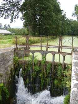 Lock in the disused part of the Nantes-Brest Canal | |
| Specifications | |
| Length | 385 km (239 mi) |
| Maximum boat length | 25.70 m |
| Maximum boat beam | 4.65 m |
| Locks | 107 (+ 45 in Finistère section) (originally 238) |
| Total rise | 555 m (1,821 ft) |
| Status | Open except for two breaks; Goariva to La Pitié, Guerlédan Dam to Pontivy |
| History | |
| Original owner | State in 1811. Canal Company of Brittany in 1822 |
| Date approved | 1802 |
| Construction began | 1811 start failed and began again in 1822 |
| Date completed | 1836 |
| Geography | |
| Start point | Brest, France |
| End point | Nantes |
| Connects to | Loire maritime Vilaine Blavet |
The Nantes-Brest canal (Canal de Nantes à Brest) is a French canal which links the two seaports of Nantes and Brest through inland Brittany. It was built in the early 19th century, and its total length as built was 385 km with 238 locks.
History
Brittany started developing its waterway network in 1538 when it decided to improve navigation on the River Vilaine. The project for a canal throughout the province was conceived by an 'inland navigation commission' convened in 1783. When Brest was blockaded by the English fleet Napoleon I of France decided to build the canal to provide a safe inland link between the two largest military ports of the French Atlantic front.[1] Building started in 1811, and Napoleon III of France presided over the canal's opening in 1858.[2]
This was the most ambitious canal project ever completed in France, 360km long with 238 locks. The canal was closed as a through route in 1920, when a section was submerged by Guerlédan dam (PK 227), a short distance west of the junction with the canalised river Blavet at Pontivy. The entire length of waterway west of Guerlédan was officially closed in 1957, and the 21km length from Pontivy to Guerlédan also subsequently fell into disuse. At the same time, the disappearance of all commercial traffic (in 26m long barges carrying up to 140 tonnes) resulted in the gradual silting up of the canal section between Rohan and Pontivy.[3]
The canal has been revived and ownership has been transferred from the State to Brittany Region, except for the short length in Pays de la Loire Region.
Navigation
Navigation is no longer possible between Pontivy and Goariva. Guerlédan reservoir flooded the canal over a length of 10 km including 17 locks.[3] However, a length of 15 km with 10 locks has been restored upstream of Guerlédan reservoir to the heritage site of La Pitié Chapel, creating a navigation 25 km long, and a public consultation was held in 2017 with a view to lifting the ban on thermal engines on this section.[4]
Three separate navigable sections are thus presented in the route below.
En Route
Canal de Nantes à Brest (East)
Pontivy to Nantes 206 km via 107 locks (using successively the rivers Erdre, Isac, Vilaine and Oust)[3]
- PK 2 Nantes
- PK 15 Sucé-sur-Erdre
- PK 21 Left turn onto the Erdre River at Nort-sur-Erdre
- PK 42.5 La Chevallerais
- PK 50 Blain
- PK 95 Redon
- PK 132 Malestroit
- PK 157.5 Josselin
- PK 182 Rohan
- PK 191.3 Saint-Gonnery begins the 5 km summit level
- PK 205.9 Pontivy, junction with the river Blavet.
Navigation interrupted from Pontivy to Guerlédan dam
Guerlédan-La Pitié section
- PK 226.8 Guerlédan dam
- PK 252.4 La Pitié
Finistère or western section
- PK 81 Goariva
- PK 73 Port-de-Carhaix, end of canal section, navigation enters canalized river Hyères
- PK 63 Maison du Canal at confluence of Hyères and Aulne rivers
- PK 43.5 Chateauneuf-du-Faou
- PK 0 Châteaulin
Tidal river Aulne and roadstead of port of Brest
- PK 0 Châteaulin
- PK 29 Landévennec.
- PK 32.5 Mouth of Aulne River
- PK 51 Roadstead of Brest Brest Harbor, Brest Bay
See also
References
- ↑ Association Canaux de Bretagne (2012). "Un peu d'histoire (brief history)".
- ↑ McKnight, Hugh (2005). Cruising French Waterways, 4th Edition. Sheridan House. ISBN 978-1574092103.
- 1 2 3 Edwards-May, David (2010). Inland Waterways of France. St Ives, Cambs., UK: Imray. pp. 169–178. ISBN 978-1-846230-14-1.
- ↑ Association Amis du Canal 22. "Consultation publique sur la navigation de la section Costamoricaine du Canal de Nantes à Brest".
External links
- Canal de Nantes à Brest with information on places, ports and moorings on the canal, by the author of Inland Waterways of France, Imray
- Navigation details for 80 French rivers and canals (French waterways website section)
| Authority control |
|---|