Nansene, Oregon
| Nansene, Oregon | |
|---|---|
| Unincorporated community | |
 Nansene, Oregon  Nansene, Oregon | |
| Coordinates: 45°24′15″N 121°03′24″W / 45.40417°N 121.05667°WCoordinates: 45°24′15″N 121°03′24″W / 45.40417°N 121.05667°W | |
| Country | United States |
| State | Oregon |
| County | Wasco |
| Elevation | 2,044 ft (623 m) |
| Time zone | UTC-8 (Pacific (PST)) |
| • Summer (DST) | UTC-7 (PDT) |
| Area code(s) | 458 and 541 |
| Coordinates and elevation from United States Geological Survey[1] | |
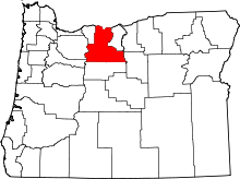
Nansene is an unincorporated community in Wasco County, in the U.S. state of Oregon.[1] It lies along Long Hollow Market Road southeast of the small city of Dufur. Between Nansene and Dufur, the road crosses Dry Creek, a tributary of Fifteenmile Creek.[2]
The name Nansene probably derives from a Native American word describing Fifteenmile Creek.[3] A post office operated in Nansene from 1880 through 1894.[3]
In the late 19th century, children in the community attended Nansene School. A school report published in The Dalles Weekly Chronicle in 1898 mentions enrollment of 5 boys and 14 girls for a total of 19 students.[4]
References
- 1 2 "Nansene". Geographic Names Information System. United States Geological Survey. May 22, 1986. Retrieved December 9, 2014.
- ↑ Oregon Atlas & Gazetteer (7th ed.). Yarmouth, Maine: DeLorme. 2008. pp. 31, 72. ISBN 978-0-89933-347-2.
- 1 2 McArthur, Lewis A.; Lewis L. McArthur (2003) [1928]. Oregon Geographic Names (7th ed.). Portland, Oregon: Oregon Historical Society Press. p. 689. ISBN 0-87595-277-1.
- ↑ "The Dalles Weekly Chronicle" (Reprint from May 25, 1898 issue). Historic Oregon Newspapers. University of Oregon Libraries. Retrieved December 10, 2014.
This article is issued from
Wikipedia.
The text is licensed under Creative Commons - Attribution - Sharealike.
Additional terms may apply for the media files.
