Nakhon Pa Mak
| Nakhon Pa Mak นครป่าหมาก (English: Betel-Palm Forest City) | |
|---|---|
| Tambon | |
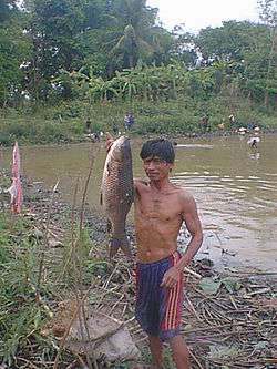 Villager demonstrating his catch in Nakhon Pa Mak | |
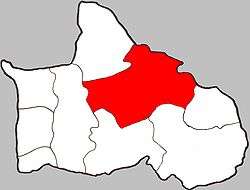 Location of Nakhon Pa Mak within Amphoe | |
| Coordinates: 16°35′45″N 100°20′53″E / 16.59583°N 100.34806°ECoordinates: 16°35′45″N 100°20′53″E / 16.59583°N 100.34806°E | |
| Country | Thailand |
| Province | Phitsanulok |
| Amphoe | Bang Krathum |
| Area | |
| • Total | 58 km2 (22 sq mi) |
| • Agricultural use | 41 km2 (16 sq mi) |
| Elevation | 41 m (135 ft) |
| Population (2005) | |
| • Total | 6,589 |
| • Density | 113/km2 (290/sq mi) |
| • Male | 3,210 |
| • Female | 3,379 |
| Time zone | UTC+7 (Thailand) |
| Postal code | 65110 |
| Geocode | 650507 |
| Chief roadway | Paved road leading to Route 1114 |
| Chief watercourse | Wang Thong River |
| Website | ThaiTambon.com |
Nakhon Pa Mak (Thai: นครป่าหมาก) is a rural subdistrict (tambon) in the Bang Krathum district of Phitsanulok Province, Thailand.[1]
Etymology
The first element nakhon (Thai: นคร) means town or city. The second element pa (Thai: ป่า) means forest. The third element mak (Thai: หมาก) means betel palm. The name as a whole would be loosely translated as Betel Palm Forest City. Betel Palm are indeed indigenous to the area and inhabitants chew on the betel nuts which contain a natural stimulant, much like chewing tobacco.
Geography
Nakhon Pa Mak primarily consists of flat lowlands[1] situated in the Nan Basin, which is part of the Chao Phraya Watershed. The Wang Thong River flows through Nakhon Pa Mak at the villages of Ban Sam Ruen and Bang Kranoi.[2] Nakhon Pa Mak borders Tha Tan to the north-west, Mae Raka of Amphoe Wang Thong to the north-east, Wat Ta Yom to the east, Phai Lom to the south, and Bang Krathum to the west.[1]
History
Originally named Sam Ruean (สามเรือน), it was renamed to Nakhon Pa Mak in 1939.[3]
Administration
The subdistrict is subdivided into 13 smaller divisions called (muban), which roughly correspond to the villages within Nakhon Pa Mak.[4] There are 8 villages, several of which occupy more than one muban.[1] Nakhon Pa Mak is administrated by a Tambon administrative organization (TAO). The muban in Nakhon Pa Mak are enumerated as follows:[5]
| No. | English | Thai |
| 1 | Ban Bueng Lam | บ้านบึงลำ |
| 2 | Ban Bang Kranoi | บ้านบางกระน้อย |
| 3, 5 & 12 | Ban Sam Ruen | บ้านสามเรือน |
| 4 | Ban Gao | บ้านเก่า |
| 6 - 8 & 13 | Ban Grong Greng | บ้านโกรงเกรง |
| 9 | Ban Laemphrathat | บ้านแหลมพระธาตุ |
| 10 | Ban Laemkrok | บ้านแหลมครก |
| 11 | Ban Dongphayom | บ้านดงพยอม |
Infrastructure
Economy

Nakhon Pa Mak's chief industry is farming,[1] primarily rice, fish, cattle, coconuts and herbs. Villagers also grow fresh fruits including bananas and mangos. There are 40 retail businesses (stores and restaurants) in Nakhon Pa Mak, and 1 factory which processes sugar cane.
Education
Nakhon Pa Mak has four elementary schools (Bueng Lam School, Wat Rat Samosom School, Wat Grung See Jayrin School and Wat Laemphrathat School).[1] Wat Rat Samoson School in Ban Sam Ruen was strictly an elementary school until around 1990, when an additional high school building was added. Prior to 1990, Nakhon Pa Mak children who wished to attend high school were required to utilize private transportation to the nearest high school in Ban Bang Krathum. There are no other high schools and no colleges or universities in Nakhon Pa Mak.[1] There is also no school bus service.
Settlements
From most populated to least, the villages of Nakhon Pa Mak are: Ban Grong Greng (pop. 1881), Ban Sam Ruen (pop. 1340), Ban Bueng Lam (pop. 1050), Ban Dongphayom (pop. 678), Bang Kranoi (pop. 567), Ban Laemphrathat (pop. 565), Ban Gao (pop. 299) and Ban Laemkrok (pop. 209).[1] From greatest land area to least, the villages rank as follows: Ban Grong Greng (20.9 km2), Ban Laemphrathat (10.4 km2), Ban Dongphayom (6.2 km2), Ban Bueng Lam (5.9 km2), Ban Sam Ruen (5.4 km2), Ban Bang Kranoi (4.4 km2), Ban Gao (2.8 km2) and Ban Laemkrok (1.8 km2).[1]
Temples
A complete list of active temples in Nakhon Pa Mak is as follows:[6]
- Wat Bunglam in Ban Bueng Lam is used primarily for funeral ceremonies.
- Wat Grung See Jayrin (has a historic chedi)
- Wat Laemphrathat
- Wat Rat Samosom
- Wat See Bun Mayiga Ram (Thai: วัดศรีบุญมายิการาม, Temple of the Renowned Merit of the Noble Lady) in Ban Laemkrok
- Wat Dongphayom
All of the temples in Nakhon Pa Mak are of the Theravada Buddhist denomination.
Attractions
References
- 1 2 3 4 5 6 7 8 9 Nakhon Pa Mak at Pitlok.net Archived 2011-07-24 at the Wayback Machine. (Thai)
- ↑ Google Earth
- ↑ พระราชกฤษฎีกาเปลี่ยนนามอำเภอ กิ่งอำเภอ และตำบลบางแห่ง พุทธศักราช ๒๔๘๒ (PDF). Royal Gazette (in Thai). 56 (ก): 354–364. April 17, 1939.
- ↑ Nakhon Pa Mak at Thaitambon.com (Thai)
- ↑ Nakhon Pa Mak at Pitlocal.org (Thai)
- ↑ Nakhon Pa Mak Temples on WebWat.net Archived 2011-07-24 at the Wayback Machine. (Thai)
- ↑ Ban Dongphayom Boat Race at Department of Agriculture Extension Archived 2007-09-19 at the Wayback Machine. (Thai)
| Wikimedia Commons has media related to Nakhon Pa Mak Subdistrict. |