Al-Hawl Subdistrict
| Al-Hawl Subdistrict ناحية الهول | |
|---|---|
| Subdistrict | |
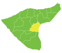 Location of Al-Hawl Subdistrict within al-Hasakah Governorate | |
| Country |
|
| Governorate | al-Hasakah |
| District | Al-Hasakah District |
| Seat | al-Hawl |
| Area | |
| • Total | 1,271.92 km2 (491.09 sq mi) |
| Population (2004)[1] | 14,804 |
| Geocode | SY080006 |
Al-Hawl Subdistrict (Arabic: ناحية الهول) is a subdistrict of al-Hasakah District in eastern al-Hasakah Governorate, northeastern Syria. Administrative centre is the town of al-Hawl.
The subdistrict is located east of al-Hasakah. It borders to the Khabur Basin to the west, and the Sinjar mountains just across the Iraqi border to the east.
At the 2004 census, it had a population of 58,916.[1]
Cities, towns and villages
| PCode | Name | Population |
|---|---|---|
| C4519 | al-Hawl | 3,409 |
| C4514 | Abu Hjera Khawatneh | 1,774 |
| C4513 | al-Khatuniyah | 1,218 |
| N/A | Tal al-Hawa | 1,102 |
| N/A | Dhi Qar | 851 |
| C4520 | Botheh Sharqia | 664 |
| C4517 | Nafayel | 631 |
| C4506 | al-Khan | 621 |
| C4522 | Khuwaytilah | 529 |
| C4516 | Shulalah | 518 |
| N/A | Sawi | 440 |
| C4518 | Atshana | 429 |
| C4507 | Janabeh Sharqi | 387 |
| C4523 | Qattara | 383 |
| C4508 | Janabeh Wasatah | 374 |
| C4510 | Um Fakik | 326 |
| C4511 | Motasarrefiyeh | 259 |
| C4521 | Nazileh | 257 |
| C4509 | Bir Jafar | 255 |
| C4512 | Abu Wishwash | 147 |
| N/A | Khuwaytilyah al-Khan | 133 |
| C4515 | Khuwaytilah Hmud | 97 |
References
- 1 2 "2004 Census Data for Nahiya al-Hawl" (in Arabic). Syrian Central Bureau of Statistics. Retrieved 15 October 2015. Also available in English: "2004 Census Data". UN OCHA. Retrieved 15 October 2015.
This article is issued from
Wikipedia.
The text is licensed under Creative Commons - Attribution - Sharealike.
Additional terms may apply for the media files.