Nadym
| Nadym Надым (Russian) | |
|---|---|
| - Town[1] - | |
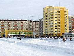 In Nadym | |
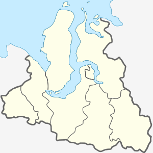
.svg.png) Location of Yamalo-Nenets Autonomous Okrug in Russia | |
 Nadym | |
.png) |
%2C_unofficial.png) |
Coat of arms |
Flag |
| Administrative status (as of September 2009) | |
| Country | Russia |
| Federal subject | Yamalo-Nenets Autonomous Okrug[1] |
| Administratively subordinated to | town of okrug significance of Nadym[1] |
| Administrative center of | Nadymsky District,[1] town of okrug significance of Nadym[1] |
| Municipal status (as of October 2012) | |
| Municipal district | Nadymsky Municipal District[2] |
| Urban settlement | Nadym Urban Settlement[2] |
| Administrative center of | Nadymsky Municipal District,[2] Nadym Urban Settlement[2] |
| Mayor | Leonid Dyachenko |
| Statistics | |
| Population (2010 Census) | 46,611 inhabitants[3] |
| Time zone | YEKT (UTC+05:00)[4] |
| Established |
1598 (first mentioned), 1968 (re-established) |
| Town status since | March 9, 1972 |
| Postal code(s)[5] | 629730 |
| Dialing code(s) | +7 3499 |
| Website |
www |
| Nadym on Wikimedia Commons | |
Nadym (Russian: Нады́м) is a town in Yamalo-Nenets Autonomous Okrug, Russia, located on the Nadym River. Population: 46,611 (2010 Census);[3] 45,943 (2002 Census);[6] 52,586 (1989 Census).[7]
Etymology
There are three several translations from the Nenets language:
- "nyadey ya" – mossy place
- "ngede ya" – dry hill,with lots of grass
- "nyada yam" – land of the Nyadong family
History
The first mention of the city's name appears at the end of the 16th century.[8] The name "Nadym" appears on Russian maps from the end of the 17th century, and the river Nadym was noted in published form at the turn of the 17th and 18th Centuries in the "Drawing Book of Siberia" by Russian geographer, cartographer and topographer, Semyon Remezov and sons, composed in 1699–1701. On the map of Tobolsk province of 1802, Nadym was already marked as having significant population. Today it's located 32 kilometers from the mouth of the river Nadym, referred to as Nadym mound.[9]
In 1929, a reindeer farm called "Nadym" was founded on the right bank of the river Nadym. However, in 1934 the farm was disbanded and turned into a factory.
In the fall of 1967, it was chosen as the reference framework for the development of a regional gas bearing deposit. Surrounded by numerous lakes, the village situated on an elevated dry place was chosen for a runway for the airline industry. Relatively small, 12 kilometers away from the river Nadym, for which it was named, by the 1950s–1960s, the village began to be called "New Nadym".
In parallel to its accelerated pace of development, the gas company created Medvezhye gas field, with the intention of becoming a social and cultural center of the Tyumen North. In August 1971, Nadym held a groundbreaking ceremony for its first major building and on March 9, 1972 by decree of the Soviet First Secretary the industrial community Nadym was incorporated within the Nadymsky Municipal District as Nadym Urban Settlement.[2][10]
Economy
The main enterprise of the town is "Nadymgazprom", it's one of the branches of the Gazprom company. which accounts for about 11% of gas produced in Russia. Also, the city contains the largest of the independent gas producers "NOVATEK" (Yurkharovskoye field).
Large construction companies are "Arktikneftegazstroy", "Severgazstroi", "Nadymdorstroy." Until 2010, their number also included the company "Severtruboprovodstroy", but in April 2011 it was declared bankrupt.
Of Nadym-based oil and gas production, "RITEKNadymneft" (a subsidiary of JSC "RITEK") led development of the Sandibinskogo and Mid-Khulymsk oil fields.
Climate
Nadym experiences a subarctic climate (Köppen climate classification Dfc). The climate is extreme, with temperatures as low as −57.7 °C (−71.9 °F) and as high as +34.7 °C (94.5 °F). On average, however, the region is very cold, with an average temperature of −5.4 °C (22.3 °F). Precipitation tends to be fairly low; 496 millimeters (19.5 in) per year, which is heavier in the summer than in the winter.
| Climate data for Nadym (1959-2012) | |||||||||||||
|---|---|---|---|---|---|---|---|---|---|---|---|---|---|
| Month | Jan | Feb | Mar | Apr | May | Jun | Jul | Aug | Sep | Oct | Nov | Dec | Year |
| Record high °C (°F) | 1.7 (35.1) |
1.0 (33.8) |
10.6 (51.1) |
20.7 (69.3) |
29.6 (85.3) |
34.2 (93.6) |
34.7 (94.5) |
32.6 (90.7) |
25.7 (78.3) |
17.0 (62.6) |
7.0 (44.6) |
10.1 (50.2) |
34.7 (94.5) |
| Average high °C (°F) | −19.4 (−2.9) |
−18.0 (−0.4) |
−9.0 (15.8) |
−2.8 (27) |
4.5 (40.1) |
15.2 (59.4) |
20.9 (69.6) |
16.3 (61.3) |
9.4 (48.9) |
−1.0 (30.2) |
−11.9 (10.6) |
−16.5 (2.3) |
−0.9 (30.4) |
| Daily mean °C (°F) | −23.7 (−10.7) |
−22.6 (−8.7) |
−14.6 (5.7) |
−8.2 (17.2) |
−0.1 (31.8) |
10.0 (50) |
15.7 (60.3) |
11.8 (53.2) |
5.8 (42.4) |
−4.0 (24.8) |
−15.8 (3.6) |
−20.9 (−5.6) |
−5.4 (22.3) |
| Average low °C (°F) | −28.3 (−18.9) |
−27.3 (−17.1) |
−20.0 (−4) |
−13.7 (7.3) |
−4.2 (24.4) |
5.4 (41.7) |
10.4 (50.7) |
7.8 (46) |
2.8 (37) |
−7.0 (19.4) |
−20.0 (−4) |
−25.5 (−13.9) |
−9.8 (14.4) |
| Record low °C (°F) | −57.7 (−71.9) |
−52.2 (−62) |
−47.1 (−52.8) |
−39.2 (−38.6) |
−25.6 (−14.1) |
−8.1 (17.4) |
−0.9 (30.4) |
−5.0 (23) |
−9.7 (14.5) |
−34.7 (−30.5) |
−47.5 (−53.5) |
−50.4 (−58.7) |
−57.7 (−71.9) |
| Average precipitation mm (inches) | 24.3 (0.957) |
19.2 (0.756) |
23.0 (0.906) |
27.3 (1.075) |
36.6 (1.441) |
57.1 (2.248) |
68.6 (2.701) |
70.5 (2.776) |
57.0 (2.244) |
51.3 (2.02) |
33.8 (1.331) |
27.6 (1.087) |
496.3 (19.539) |
| Average precipitation days (≥ 0.1 mm) | 18.6 | 15.5 | 15.8 | 13.4 | 14.3 | 13.6 | 12.7 | 15.9 | 16.0 | 20.0 | 18.9 | 19.1 | 193.8 |
| Source: climatebase.ru | |||||||||||||
Education
The city has nine schools. A high school, a college (Since 2014 PU 4 received the status of college) and two art schools. The higher education system is represented by four branches of higher educational institutions of Russia:
- the branch of Tyumen State University
- the branch of Tyumen State Oil and Gas University
- the branch of the Moscow University of Psychology and Social
- the branch of Tomsk State University of Control Systems and Radio Electronics (TUSUR).
- a branch of Tyumen State Architectural University (TyumGASU).
Transportation
Bus routes: Airport-number 2> n. Forest Avtostantsiya- number 3> n. Right Bank Number 4 Finskiy-> 11 th md Number 5 para. Lesnoy-> 11 th md Number 6 Street. Ryzhkova-> Administration Nadym (Airport)
A railway branch passes through Nadym between Novy Urengoy and Salekhard which is closed and inactivated (also called "dead road", a Stalinist-era road). At some point in time a bridge across the Ob river to Salekhard Labytnangi was planned. To date, the only construction is the railway Salekhard-Nadym. Most roads across the river Nadym were opened in September 2015. A bridge across the Ob River is also in the planning along with a road running parallel to the railroad.
The Nadym Airport is on the west bank of the Nadym River.
Culture
Museum of Tanya Savicheva operates in Nadym's School #2.
Interesting facts
- Nadym was the nearest town to the point of greatest viewing for the eclipse of solar eclipse of August 1, 2008.
- Trough Nadym passses The 1,524 mm (5 ft) broad gauge Salekhard–Igarka Railway, which is also called "The Dead Road".
- According to the documents published by the Wikileaks magazine Nadym gas pipeline unit is named the most critical gas facility in the world. [11].
International relations
Twin towns and sister cities
Nadym is twinned with:
Illustrations
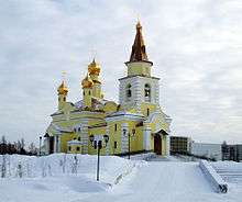
- St.Nicholas Church
 Wedding Palace
 Mosque
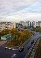 Leningradsky prospekt
 Park
Park Valery Remizov monument
References
Notes
- 1 2 3 4 5 Law #42-ZAO
- 1 2 3 4 5 Law #111-ZAO
- 1 2 Russian Federal State Statistics Service (2011). "Всероссийская перепись населения 2010 года. Том 1" [2010 All-Russian Population Census, vol. 1]. Всероссийская перепись населения 2010 года (2010 All-Russia Population Census) (in Russian). Federal State Statistics Service. Retrieved June 29, 2012.
- ↑ Правительство Российской Федерации. Федеральный закон №107-ФЗ от 3 июня 2011 г. «Об исчислении времени», в ред. Федерального закона №271-ФЗ от 03 июля 2016 г. «О внесении изменений в Федеральный закон "Об исчислении времени"». Вступил в силу по истечении шестидесяти дней после дня официального опубликования (6 августа 2011 г.). Опубликован: "Российская газета", №120, 6 июня 2011 г. (Government of the Russian Federation. Federal Law #107-FZ of June 31, 2011 On Calculating Time, as amended by the Federal Law #271-FZ of July 03, 2016 On Amending Federal Law "On Calculating Time". Effective as of after sixty days following the day of the official publication.).
- ↑ Почта России. Информационно-вычислительный центр ОАСУ РПО. (Russian Post). Поиск объектов почтовой связи (Postal Objects Search) (in Russian)
- ↑ Russian Federal State Statistics Service (May 21, 2004). "Численность населения России, субъектов Российской Федерации в составе федеральных округов, районов, городских поселений, сельских населённых пунктов – районных центров и сельских населённых пунктов с населением 3 тысячи и более человек" [Population of Russia, Its Federal Districts, Federal Subjects, Districts, Urban Localities, Rural Localities—Administrative Centers, and Rural Localities with Population of Over 3,000] (XLS). Всероссийская перепись населения 2002 года [All-Russia Population Census of 2002] (in Russian). Retrieved August 9, 2014.
- ↑ Demoscope Weekly (1989). "Всесоюзная перепись населения 1989 г. Численность наличного населения союзных и автономных республик, автономных областей и округов, краёв, областей, районов, городских поселений и сёл-райцентров" [All Union Population Census of 1989: Present Population of Union and Autonomous Republics, Autonomous Oblasts and Okrugs, Krais, Oblasts, Districts, Urban Settlements, and Villages Serving as District Administrative Centers]. Всесоюзная перепись населения 1989 года [All-Union Population Census of 1989] (in Russian). Институт демографии Национального исследовательского университета: Высшая школа экономики [Institute of Demography at the National Research University: Higher School of Economics]. Retrieved August 9, 2014.
- ↑ Мангазейский морской путь
- ↑ Надымский район: История // nadymregion.ru
- ↑ Надымский район > Город Надым > История города // nadymregion.ru
- ↑ Cable viewer Archived December 24, 2010, at the Wayback Machine.
Sources
- Государственная Дума Ямало-Ненецкого автономного округа. Закон №42-ЗАО от 6 октября 2006 г. «Об административно-территориальном устройстве Ямало-Ненецкого автономного округа», в ред. Закона №123-ЗАО от 6 декабря 2012 г. «О внесении изменений в некоторые Законы Ямало-Ненецкого автономного округа в части изменения вида населённого пункт Тазовский путём отнесения его к сельским пунктам и наделении муниципального образования посёлок Тазовский статусом сельского поселения». Вступил в силу по истечении десяти дней со дня официального опубликования. Опубликован: "Красный Север", №119, 13 октября 2006 г. (State Duma of Yamalo-Nenets Autonomous Okrug. Law #42-ZAO of October 6, 2006 On the Administrative-Territorial Structure of Yamalo-Nenets Autonomous Okrug, as amended by the Law #123-ZAO of December 6, 2012 On Amending Various Laws of Yamalo-Nenets Autonomous Okrug Due to Changing the Status of the Inhabited Locality of Tazovsky to a Rural Locality and on Granting the Municipal Formation of the Settlement of Tazovsky the Status of a Rural Settlement. Effective as of the day upon expiration of ten days from the official publication date.).
- Государственная Дума Ямало-Ненецкого автономного округа. Закон №111-ЗАО от 20 декабря 2004 г. «О наделении статусом, определении административного центра и установлении границ муниципальных образований Надымского района», в ред. Закона №108-ЗАО от 28 октября 2013 г. «О внесении изменения в Закон Ямало-Ненецкого автономного округа "О наделении статусом, определении административного центра и установлении границ муниципальных образований Надымского района"». Вступил в силу со дня официального опубликования, за исключением положений, связанных с использованием географического наименования посёлка Заполярный, вступающих в силу со дня принятия соответствующего акта Правительства РФ. Опубликован: "Красный Север", спецвыпуск №6, 31 января 2005 г. (State Duma of Yamalo-Nenets Autonomous Okrug. Law #111-ZAO of December 20, 2004 On Granting the Status, Determining the Administrative Center, and Establishing the Borders of the Municipal Formations of Nadymsky District, as amended by the Law #108-ZAO of October 28, 2013 On Amending the Law of Yamalo-Nenets Autonomous Okrug "On Granting the Status, Determining the Administrative Center, and Establishing the Borders of the Municipal Formations of Nadymsky District". Effective as of the day of the official publication, with the exception of clauses dealing with the usage of the geographical name of the settlement of Zapolyarny, which take effect on the day the appropriate act by the Government of the Russian Federation is adopted.).
External links
- Official website of Yamalo-Nenets Autonomous Okrug. Information about Nadym
Administrative center: Salekhard • Rural localities | |||
| Districts | |||
| Cities and towns | |||
| Urban-type settlements | |||