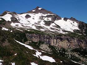
Naafkopf
| Naafkopf | |
|---|---|
 From East | |
| Highest point | |
| Elevation | 2,570 m (8,430 ft) |
| Prominence | 222 m (728 ft) [1] |
| Isolation | 1.62 kilometres (1.01 mi) |
| Parent peak | Grauspitz |
| Coordinates | 47°03′38.54″N 9°36′25.75″E / 47.0607056°N 9.6071528°ECoordinates: 47°03′38.54″N 9°36′25.75″E / 47.0607056°N 9.6071528°E |
| Geography | |
 Naafkopf Location in the Alps | |
| Location |
Graubünden, Switzerland Vorarlberg, Austria Schaan, Liechtenstein |
| Parent range | Rätikon |
The Naafkopf is a mountain in the Rätikon range of the Alps, located at the border between Austria, Liechtenstein and Switzerland.
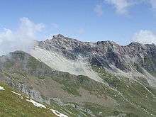
Naafkopf and the ridge above Ijes
References
External links
This article is issued from
Wikipedia.
The text is licensed under Creative Commons - Attribution - Sharealike.
Additional terms may apply for the media files.