Nørager
| Nørager | |
|---|---|
| Town | |
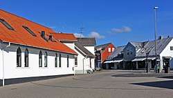 The center of Nørager. | |
 Nørager Location in Denmark | |
| Coordinates: 56°42′25″N 9°37′50″E / 56.70694°N 9.63056°ECoordinates: 56°42′25″N 9°37′50″E / 56.70694°N 9.63056°E | |
| Country |
|
| Region | Region Nordjylland |
| Municipality | Rebild |
| Foundation | 1891 |
| Population (2017) | |
| • Total | 1,168 |
| Time zone | UTC+1 (CET) |
| • Summer (DST) | UTC+1 (CEST) |
| Postal code | 9610 |
| Website | www.rebild.dk |
Nørager is a town with a population of 1,040 (1 January 2014)[1] in Rebild municipality in Region Nordjylland on the Jutland peninsula in northern Denmark. It is the former municipal seat of the Nørager Municipality. Nørager is 15 km from Aars and is 26 km from Støvring which is municipal seat of the current Municipality that Nørager is in.
History
In the town lies the manor house Nøragergård, which has been known since the Middle Ages. The farm burned in 2005 and was rebuilt in 2011. After that, Nørager inn is now the oldest standing building in Nørager since it was built in 1891, since there is no church in the town itself.
Nørager had a station on the line Hobro-Aalestrup (1893-1966), which was part of the Himmerlands runways. The station was a little northwest of Nøragergård. In addition to a circulation track there was a loading trail at each end of the station. Nørager Station was still in use in 1966. After closure, it served as a post office and bus service. The warehouse was demolished in 1982 and the rest of the station on Jernbanegade 9 was demolished in 2016 to accommodate a new municipal administration building.
Nørager Municipality
The former Nørager municipality covered an area of 168 km², and had a total population of 5,565 (2005). Its last mayor was Poul Larsen, a member of the Conservative People's Party (Det Konservative Folkeparti) political party.
On January 1, 2007 Nørager municipality ceased to exist as the result of Kommunalreformen ("The Municipality Reform" of 2007). It was merged with Skørping and Støvring municipalities to form the new Rebild Municipality. This created a municipality with an area of 628 km² and a total population of 28,457 (2005).
External links
References
- ↑ BEF44: Population 1st January, by urban areas database from Statistics Denmark
- Municipal statistics: NetBorger Kommunefakta, delivered from KMD aka Kommunedata (Municipal Data)
- Municipal mergers and neighbors: Eniro new municipalities map