Nærbø (municipality)
| Nærbø herad | |
|---|---|
| Former Municipality | |
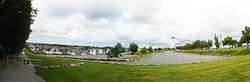 Panorama of Nærbø | |
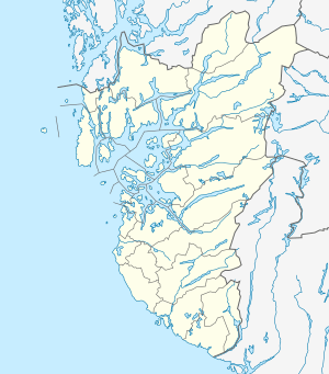 Nærbø herad Location in Rogaland county | |
| Coordinates: 58°39′55″N 05°38′16″E / 58.66528°N 5.63778°ECoordinates: 58°39′55″N 05°38′16″E / 58.66528°N 5.63778°E | |
| Country | Norway |
| Region | Western Norway |
| County | Rogaland |
| District | Jæren |
| Municipality ID | NO-1119 |
| Adm. Center | Nærbø |
| Area[1] | |
| • Total | 65 km2 (25 sq mi) |
| Time zone | UTC+01:00 (CET) |
| • Summer (DST) | UTC+02:00 (CEST) |
| Created from | Hå in 1894 |
| Merged into | Hå in 1964 |
Nærbø is a former municipality in Rogaland county, Norway. The administrative centre of the municipality was the village of Nærbø where the Old Nærbø Church is located. The 65-square-kilometre (25 sq mi) municipality was located in the district of Jæren inside the northern part of the present-day municipality of Hå. The municipality existed from 1894 until its dissolution in 1964.[1]
History
The municipality of Nærbø was established in 1894 when the old municipality of Hå was split in half into Varhaug and Nærbø. Initially, Nærbø had 1,806 residents. On 1 January 1964, there were many municipal mergers across Norway due to the work of the Schei Committee. On that date, the municipalities of Nærbø (population: 3,926), Varhaug (population: 3,454), and Ogna (population: 1,470).[2]
See also
References
- 1 2 Store norske leksikon. "Nærbø – tidligere kommune" (in Norwegian). Retrieved 2016-06-09.
- ↑ Jukvam, Dag (1999). "Historisk oversikt over endringer i kommune- og fylkesinndelingen" (PDF) (in Norwegian). Statistisk sentralbyrå.