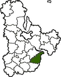
Myronivka Raion
| Myronivka Raion Миронівський район | |||
|---|---|---|---|
| Raion | |||
| |||
 | |||
| Coordinates: 49°44′56″N 31°2′21″E / 49.74889°N 31.03917°ECoordinates: 49°44′56″N 31°2′21″E / 49.74889°N 31.03917°E | |||
| Country |
| ||
| Region | Kiev Oblast | ||
| Admin. center | Myronivka | ||
| Subdivisions |
List
| ||
| Time zone | UTC+2 (EET) | ||
| • Summer (DST) | UTC+3 (EEST) | ||
| Area code | +380 | ||
Myronivka Raion (Ukrainian: Миронівський район) is a raion (district) in Kiev Oblast of Ukraine. Its administrative center is the urban-type settlement of Myronivka. Population: 35,026 (2013 est.)[1].
References
- ↑ "Чисельність наявного населення України (Actual population of Ukraine)" (in Ukrainian). State Statistics Service of Ukraine. Retrieved 21 January 2015.
| Raions | |||||
|---|---|---|---|---|---|
| Cities |
| ||||
| |||||
This article is issued from
Wikipedia.
The text is licensed under Creative Commons - Attribution - Sharealike.
Additional terms may apply for the media files.