Mynydd Drws-y-Coed
| Mynydd Drws-y-Coed | |
|---|---|
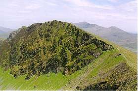 Mynydd Drws-y-Coed from Trum y Ddysgl | |
| Highest point | |
| Elevation | 695 m (2,280 ft) |
| Prominence | 57 m (187 ft) |
| Listing | Hewitt, Nuttall |
| Geography | |
| Location | Gwynedd, Wales |
| Parent range | Moel Hebog |
| Topo map |
OS Landranger 115, OS Outdoor Leisure 17 |
| Climbing | |
| Easiest route | Walk, Scramble |
| Listed summits of Mynydd Drws-y-Coed | ||||
| Name | Grid ref | Height | Status | |
|---|---|---|---|---|
| Y Garn | SH551525 | 633 metres (2,077 ft) | sub Hewitt, Nuttall | |
Mynydd Drws-y-Coed is a peak on the Nantlle Ridge in Snowdonia, north Wales. It is located at the easterly end of the ridge, and is a subsidiary summit of Trum y Ddysgl. It has steep south facing cliffs, the summit area being the highest point on a thin ridge.[1]
The west side is very rocky and airy, and some scrambling is needed to attain the summit. A good head for heights will also be needed on the exposed regions.[2]
References
- ↑ Nuttall, John & Anne (1999). The Mountains of England & Wales - Volume 1: Wales (2nd edition ed.). Milnthorpe, Cumbria: Cicerone. ISBN 1-85284-304-7.
- ↑ Crocker, Chris; Graham Jackson. "Mountaineering & Rock Climbing in the UK: Mynydd Drws-y-Coed". Database of British Hills. Mountain Days.net. Archived from the original on 2011-07-19. Retrieved 2008-04-08.
Coordinates: 53°02′43″N 04°09′50″W / 53.04528°N 4.16389°W
This article is issued from
Wikipedia.
The text is licensed under Creative Commons - Attribution - Sharealike.
Additional terms may apply for the media files.