Myczkowce
| Myczkowce | |
|---|---|
| Village | |
 Myczkowce | |
| Coordinates: 49°26′14″N 22°24′37″E / 49.43722°N 22.41028°E | |
| Country |
|
| Voivodeship | Subcarpathian |
| County | Lesko |
| Gmina | Solina |
| Population | 510 |
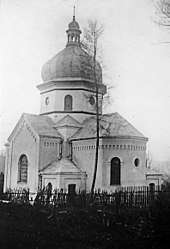
Myczkowce [mɨt͡ʂˈkɔft͡sɛ] (Ukrainian: Мичківці, Mychkivtsi) is a village in the administrative district of Gmina Solina, within Lesko County, Subcarpathian Voivodeship, in south-eastern Poland. It lies approximately 8 kilometres (5 mi) north-west of Solina, 8 km (5 mi) south-east of Lesko, and 73 km (45 mi) south-east of the regional capital Rzeszów.[1] In 1910-1914, new ukrainian church instead of a wooden one from 1815, was built. A monumental structure was designed as a synthesis of Ukrainian, Byzantine and Romanesque architectural traditions. Religious community was affiliated with and the Diocese of Peremyshl`. After the deportation of Ukrainians, was used for the storage, and since 1979 - as a church for Polish Roman Catholic community The village has a population of 510.
References
| Seat |  | |
|---|---|---|
| Other villages | ||
Coordinates: 49°26′14″N 22°24′37″E / 49.43722°N 22.41028°E