Musafirkhana
| Musafirkana Dharamshala | |
|---|---|
| City | |
| Nickname(s): Sarai | |
 Musafirkana Location in Uttar Pradesh, India | |
| Coordinates: 26°27′N 81°48′E / 26.450°N 81.800°ECoordinates: 26°27′N 81°48′E / 26.450°N 81.800°E | |
| Country | India |
| State | Uttar Pradesh |
| District | Amethi |
| Elevation | 102 m (335 ft) |
| Population (2001) | |
| • Total | 7,373 |
| Demonym(s) | Musafirkhanan |
| Languages | |
| • Official | Hindi |
| Time zone | UTC+5:30 (IST) |
| PIN | 227813 |
| Website |
amethi |
Musafirkhana is a Tehsil in Amethi district in Indian state of Uttar Pradesh. The word "Musafirkhana" means "Sarai," or "Dharamshala". Musafirkhana is located 32 km northwest of Amethi, 27 km from Nihalgarh and 20 km from Jagdishpur. Gauriganj and Amethi are accessible from Musafirkhana via roadways; the nearest railway station is the Musafirkhana railway station on the Lucknow–Varanasi rail route via Sultanpur, and the nearest airport is the Amausi airport. It is surrounded by more than 100 villages. The town is between 26.37° north latitude and 81.8° east longitude at a height of 102 metres (434 feet) above mean sea level.
Geography
Musafirkhana is located at 26°22′N 81°48′E / 26.37°N 81.8°E.[1] It has an average elevation of 102 metres (334 feet).
It belongs to the Faizabad division. It is located 35 km towards west from the district headquarters Sultanpur. It is a tehsil headquarter.
Bisara Paschim (2 km), Dharauli (2 km), Pure Prem Shah (3 km), Pindara Karnai (3 km), Kasthuni Paschim (3 km) are some nearby villages of Musafirkhana. Musafirkhana is surrounded by Baldirai Tehsil towards the East, Milkipur Tehsil towards the East, Shahgarh Tehsil towards the South, and Jamo Tehsil towards the West.
Jais, Sultanpur, Rudauli, and Faizabad are nearby cities to Musafirkhana.
It is on the border of the Sultanpur District and Faizabad District Amaniganj, with the latter toward the North.
Demographics
According to the Census of India conducted in 2001,[2] Musafirkhana had a population of 7,373. Males constituted 53% of the population and females 47%. Musafirkhana has an average literacy rate of 66%, higher than the national average of 59.5%: male literacy is 75%, and female literacy is 57%. In Musafirkhana, 15% of the population is under 6 years of age.
The most commonly spoken language in Musafirkhana is Awadhi, though the people also speak Hindi and Urdu.
Pin Codes of Musafirkhana Tehsil
- Musafirkhana - 227813
- Pindara - 227807
- Aliganj Bazar - 227805,
- Raniganj (Sultanpur) - 227816
- Bazar Baldirai - 227806
- Kurebhar - 228151
Temples
- Mahadevan Temple
- Baba Nand Mahar is Yadav's temple in memory of Krishna. It is believed that God Krishna had arrived there in his childhood. This temple is famous for Yadav's worship to his local cast god Rajabali and Pawaria. Every Tuesday, people come with milk to worship Krishna in the temple. Every year a large fair is held in the temple, on the Hindi month of Kartik (Ashwin) Purnima. It is important to note that Yadavs from different districts (Amethi, Faizabad, Bahrich, Gonda, Ambedkarnagar, Pratapgargh, Raibareli, Barabanki) and other surrounding villages usually come here and worship the gods Rajabali and Pawaria.
- Durgan Bhawani is the temple of Durga and Hanuman.
- Santoshi Mata temple is the temple of Santoshi, 6 km from Musafirkhana on the Jamon road. TheSantoshi Mata Temple is in Tiwari ka purwa, Barehati village. Every Friday, people come and wish for their wellness and blessings.
- The Maa Hinglaj temple, Baba Purushottam Das temple, Khaki Baba temple, Phoolmati Mata temple (in Poorab Pati) and Bhoodhe Baba (Prem Nagar) are renowned temples of the village Dadra which is located 5 km from Musafirkhana. The Maa Hinglaj temple is a very famous temple and is about 500 years old.
Transport
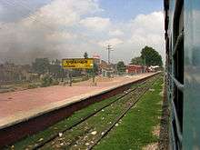
Musafirkhana has a railway station (500 meters from its center location), which falls on the Varanasi-Lucknow rail route. There is connectivity of Musafirkhana from the capital of UP i.e. Lucknow by bus or train. However Amethi Railway Station is major railway station 27 km near to Musafirkhana.
Airports
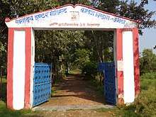
Schools and Colleges
Schools
- A.H. Inter College, Musafirkhana
- Shanti Niketan Public School Block Road Musafirkhana
- Sarvoday Inter College
- Green Wood Public School
- W.H.Public School
- Bharat Public School
- City Montessori School
- Mother Teresa Convent School
- Saraswati Sishu Mandir & Vidya Mandir
- Dayanand Junior High School
- Primary & Junior School Girls
- J.N Public School Pure Prem Shah Musafirkhana
- Nirmala Devi Public School
- Satyashodhak Shiksha Sadan
Colleges
- Ambe Rai Inter College, Gajanpur Duwariya Amethi
- Rajeev Gandhi Polytechnic Institute, Musafirkhana
- Govt. P.G. College, Musafirkhana
Nearby Villages
- Dadra− Dadra is one of the famous villages of Musafirkhana. It is about 5 km north from Musafirkhana and at the bank of Gomti river. It is a populated and pious village. Here, the main employment is agriculture. It is very famous for the Goddess Devi Hinglaj temple and Baba Purushottam Das temple. Devi Hinglaj temple is nearly 500 years old and was built by Bais Chhatriya Rao Rupmal who were influenced by the Hindu saint Baba Purushottam Das who was an Awadhi poet, and a pious person who wrote a mahakavya named "Jaiminiyaashwaghbhasha".
- Pure Prem Shah− It is also a near by village.
References
- ↑ Falling Rain Genomics, Inc - Musafirkhana
- ↑ "Census of India 2001: Data from the 2001 Census, including cities, villages and towns (Provisional)". Census Commission of India. Archived from the original on 2004-06-16. Retrieved 2008-11-01.