Murrumbeena, Victoria
| Murrumbeena Melbourne, Victoria | |||||||||||||||
|---|---|---|---|---|---|---|---|---|---|---|---|---|---|---|---|
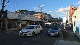 Shops on Neerim Road with Murrumbeena station in the background. | |||||||||||||||
 Murrumbeena | |||||||||||||||
| Coordinates | 37°53′56″S 145°04′19″E / 37.899°S 145.072°ECoordinates: 37°53′56″S 145°04′19″E / 37.899°S 145.072°E | ||||||||||||||
| Population | 9,926 (2016 census)[1] | ||||||||||||||
| • Density | 3,970/km2 (10,280/sq mi) | ||||||||||||||
| Postcode(s) | 3163 | ||||||||||||||
| Area | 2.5 km2 (1.0 sq mi) | ||||||||||||||
| Location | 13 km (8 mi) from Melbourne | ||||||||||||||
| LGA(s) | City of Glen Eira | ||||||||||||||
| State electorate(s) | Oakleigh | ||||||||||||||
| Federal Division(s) | |||||||||||||||
| |||||||||||||||
Murrumbeena is a suburb in Melbourne, Victoria, Australia, 13 km south-east of Melbourne's central business district.[2] Its local government area is the City of Glen Eira. At the 2016 Census, Murrumbeena had a population of 9,926.[3]
Murrumbeena is a small suburban area with extensive parklands and primarily federation and interwar architectural character.
Toponomy
The name "Murrumbeena" derives from the Aboriginal word "mirambeena". It may have meant "land of frogs", "moss growing on decayed wood" or it may be a derivative from the name of an Aboriginal elder. The evidence for any of these etymologies is uncertain.[4] The name was officially adopted when the railway station opened in 1879.[5]
History
- 14 May 1879 – Murrumbeena Railway station opens.[6]
- 21 September 1889 – Railway station signal box contract signed to erect by J. Brown.[7]
- 12 May 1890 – Murrumbeena Post Office opens.[8]
- 1922 – Electrification of railway & wicket gates.[7]
- 1972 – Shorting of railway siding at station used to deliver coal and goods.[7]
- 6 December 1977 – Removal of railway siding at station.[7]
- 7 February 2016 – The Victorian government announces plans for a elevated rail project to run through Carnegie, Murrumbeena and Hughesdale.
- 18 June 2018 - New elevated station opens
Main Street
The main street of Murrumbeena is Neerim Road, which bends to cross the railway lines and has a strip shopping centre extending to Murrumbeena Road nearby the railway station. Trading at the shopping centre suffered greatly with the opening of Chadstone Shopping Centre nearby, however it has seen a recent revival, particularly of street cafes and apartment building.
Transport
The main roads running through Murrumbeena are Dandenong Road, Neerim Road and Murrumbeena Road.
Murrumbeena railway station is a suburban railway station providing regular services to the city and along the Pakenham and Cranbourne lines.
The Neerim Road level crossing was identified by the RACV in 2010 as one of the worst for traffic congestion in metropolitan Melbourne.[9]
In 2016, the Victorian government announced it would construct an elevated railway bridge to remove level crossings on the Pakenham/Cranbourne line. The proposed construction will consist of three concrete bridge-like structures, each spanning multiple kilometres and composed of sections varying in height from 9 to 16 metres.
Housing

Outside of the main street, Murrumbeena is a mix of predominantly single-family detached homes with small pockets of walk-up flats of up to two stories developed since the 1960s. The predominant style of the buildings in the shopping strip, station and surrounding homes are Federation and Interwar which include many magnificent examples of single story Art Deco designs.
Schools
Murrumbeena Primary School
- 1910 Current site purchased
- 1917 Current site occupied
St Patrick's Catholic Primary School
Murrumbeena High School
Murrumbeena High School originally occupied a large parcel of land on the corner of Murrumbeena Road and North Road across the road from Duncan McKinnon Reserve. (801 North Rd, Murrumbeena 3163)
Sport
The suburb has an Australian Rules football team competing in the Southern Football League with a history that can be traced back to the formation of the Murrumbeena Junior Football Club in 1918. They have junior and senior sides.[12] It has a lawn bowls club situated in Gerald Street which fields two teams in the Bowls Victoria Pennant competition.
Sporting clubs:
- Murrumbeena Football Club – Founded in 1918.
- Murrumbeena Cricket Club – Founded in 1910.
- Murrumbeena Park Bowls Club.
Notable people

- The potter Merric Boyd (1888–1959) established a studio in Murrumbeena and produced his own distinctive style of Art Nouveau ceramics. Through the Boyds, Murrumbeena played host to other well-known artists including John Perceval, Sidney Nolan, Hatton Beck, and Peter Herbst.
- Arthur Boyd (1920–1999) was one of the leading Australian painter of the late 20th Century.
- Mark Trevorrow, the creator of Bob Downe, the camp safari-suit wearing comic and singer was born and raised in Murrumbeena.
- Musician Nick Cave grew up in the suburb, and TISM played their first show at the Murrumbeena athletics track club rooms.
- Paralympic swimming medallist Phillip Tracey was from the suburb.[13]
- Many Australian Rules footballers including Robert Flower from 1973 until 1987, Tom Flower, Ray Carr, Mark Mitchell, Howard Hollow and Ken Jungworth who all played with Melbourne Demons went to school or came from Murrumbeena Football Club and also grew up in the suburb.
- Bill Shorten, the Member for Maribyrnong in the Australian Parliament, grew up in Neerim Rd, Murrumbeena and attended Mass at the Good Shepherd Convent, on the current site of Chadstone Shopping Centre. He is the Leader of the Australian Labor Party and Leader of the Opposition in the Australian House of Representatives.
References
- ↑ Australian Bureau of Statistics (27 June 2017). "Murrumbeena (State Suburb)". 2016 Census QuickStats. Retrieved 19 March 2018.

- ↑ Postcodes Australia Profile
- ↑ Australian Bureau of Statistics (27 June 2017). "Murrumbeena". 2016 Census QuickStats. Retrieved 21 June 2012.
- ↑ What does Murrumbeena Mean?, Murrumbeena Community, retrieved 25 July 2010
- ↑ Brown-May, Andrew & Swain, Shurlee: The Encycploedia Of Melbourne, page 496. Cambridge University Press, 2005.
- ↑ "VICSIG". vicsig.net. Retrieved 2017-09-10.
- 1 2 3 4 "VHD". vhd.heritage.vic.gov.au. Retrieved 2017-09-10.
- ↑ Premier Postal History, Post Office List, retrieved 11 April 2008
- ↑ Lucas, Clay (21 September 2010). "Level crossings choking city traffic flow: RACV". The Age. Melbourne.
- ↑ "Art Block". Murrumbeena High School Reunion. Archived from the original on 2010-05-13. Retrieved 2018-09-24.
- ↑ Topsfield, Jewel (19 November 2010). "All set for high school but closures leave no place to go". The Age. Retrieved 19 February 2018.
- ↑ Full Point Footy, Southern Football League, retrieved 21 October 2008
- ↑ "SA husband and wife both get gold at Paralympics". Canberra Times. 23 October 1988. Retrieved 1 January 2015.
| Wikimedia Commons has media related to Murrumbeena, Victoria. |