Murr (river)
| Murr | |
|---|---|
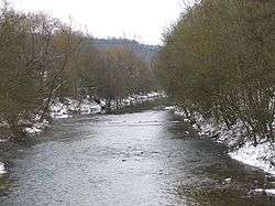 The Murr near Steinheim | |
| Country | Germany |
| Physical characteristics | |
| Main source | Swabia |
| River mouth |
Neckar 48°56′48″N 9°15′5″E / 48.94667°N 9.25139°ECoordinates: 48°56′48″N 9°15′5″E / 48.94667°N 9.25139°E |
| Length | 51.8 km (32.2 mi) [1] |
| Basin features | |
| Progression | Neckar→ Rhine→ North Sea |
| Basin size | 507 km2 (196 sq mi) [1] |
The ![]()
Its source is approx. 4 km south of Murrhardt. It flows northeast before turning west to cross Murrhardt. After a further 7 km, Sulzbach an der Murr is reached. Here, at its northernmost point, the Lauter joins from the north, coming from Spiegelberg. The Murr continues southwest, passing Oppenweiler to reach Backnang, where its narrow valley widens. Further towns on its way are Burgstall an der Murr, Kirchberg an der Murr, Steinheim an der Murr, and the community of Murr itself, which is located in the district of Ludwigsburg.
North of Marbach am Neckar, the Murr joins the Neckar after having travelled about 50 km in total.
The Murr runs south of the Löwenstein Hills. A large part of the river is situated in the Swabian-Franconian Forest, after which the eponymous nature park was named.
References
External links