Muno, Belgium
| Muno | |
|---|---|
| Municipality | |
 Muno Location in Belgium
Location of Muno in Belgium 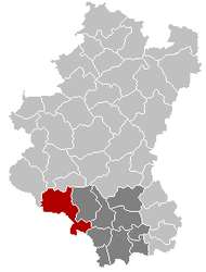 | |
| Coordinates: 49°43′N 05°10.5′E / 49.717°N 5.1750°ECoordinates: 49°43′N 05°10.5′E / 49.717°N 5.1750°E | |
| Country | Belgium |
| Community | French Community |
| Region | Wallonia |
| Province | Luxembourg |
| Arrondissement | Arrondissement of Virton |
| Area | |
| • Total | 146.91 km2 (56.72 sq mi) |
| Population (1 January 2017)[1] | |
| • Total | 5,628 |
| • Density | 38/km2 (99/sq mi) |
| Postal codes | 6820 |
| Area codes | 061 |
| Website | Muno |
Muno is a village forming part of the municipality of Florenville in Belgium. It lies in the country's Walloon Region and in the province of Luxembourg.
A 6-km-long section of the former (line 163A) railway between Muno and Sainte-Cécile, dismantled in 1972, has been converted into a bicycle trail.
Geography
The village is limited on its south-western side by the border with France.
References
- ↑ Population per municipality as of 1 January 2017 (XLS; 397 KB)
External links
- Official web site (in French)
This article is issued from
Wikipedia.
The text is licensed under Creative Commons - Attribution - Sharealike.
Additional terms may apply for the media files.