Munkurin
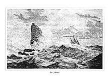
Munkurin is the southernmost point of the Faroe Islands. Munkurin is an 11 metre high rock, also known as Sumbiarsteinur. Munkur means "monk". The rock is one of a group of skerries, called Flesjarnar, 5 km south of the island Suðuroy in the Faroe Islands. The sound between Flesjarnar and Suðuroy is notorious for its strong current.
Flesjarnar
Flesjarnar are a group of rocks, located 5 km south of Akraberg in Suðuroy. The rocks are:
- Sumbiarfles, 4 metre high (nearest to land)
- Miðjufles, 4 metre high (The word miðju means in the middle)
- Bøllufles, 6 metre high (two rocks)
- Stórafles, 7 metre high (Stóra means large)
- Munkurin or Sumbiarsteinur, 11 meter high
Munkurin
The rocks are close together except for Munkurin which is a little further away, which is possibly why it is called the Monk. One source mentions another reason for the name Munkurin, and that is before the islet collapsed. The article tells about the observations of Pastor Jørgen Landt wrote in 1800, that when seen from land the rock-island presented the appearance of a monk with red neck and dark grey body and head; and from sea it looked like a ship under full sails. The article mentions that the Monk was 70 feet (21 meters) high.[1] Munkurin is now 11 metres high, but it used to be higher earlier. It collapsed in 1884/85. Before it collapsed the bird northern gannet (Morus bassanus) used to nest there, but since it collapsed the birds don't nest there any more, they nest in Mykineshólmur. It happens sometimes that the rock looks white from land, and that is because there are many northern gannets sitting there.
Literature in German and Danish
- Lucas Jacobson Debes: Natürliche und Politische Historie der Inseln Färöe. The German book is translated from Danish. Writer: C. G. Mengel, Copenhagen / Leipzig 1757.
See also
References
- A Map of the Faroe Islands
- Also based on the German version of Wikipedia.
External links
Coordinates: 61°20′N 6°40′W / 61.333°N 6.667°W