Administrative subdivision of Rome
The administrative subdivisions of Rome consist of the 15 sub-municipalities (municipi) of Rome's municipality (comune).
Originally, the city was divided into 20 sub-municipalities, but the XIV, what is now the Comune di Fiumicino, voted in 1992 to become a full municipality itself and eventually detached from Rome. Then on 11 March 2013 the municipalities were reduced from 19 to 15.
History
Since 1972 the city has been divided into administrative areas, called municipi (singular: municipio), until 2001 named circoscrizioni.[1] They were created for administrative reasons to increase decentralisation in the city. Each municipio is governed by a president and a council who are elected directly by its residents every five years since 1997. The municipi frequently cross the boundaries of the traditional, non-administrative divisions of the city.
There were originally 20 municipi, becoming 19 in 1992 after a referendum and the subsequent separation of Fiumicino (XIX Municipio) into an independent Comune. In 2013 their number was reduced to 15.[2]
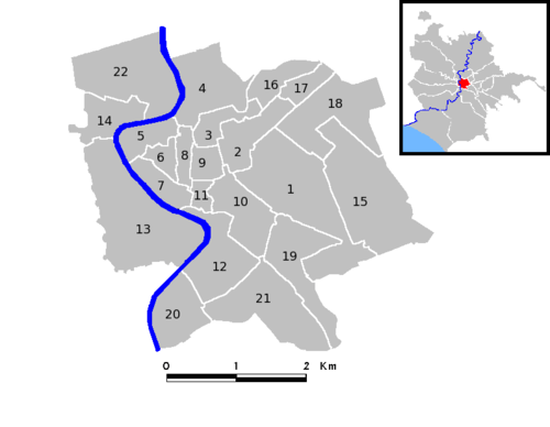
Rome is also divided into several types of non-administrative units. The historic centre is divided into 22 rioni, all of which are located within the Aurelian Walls except Prati and Borgo. These originate from the Regiones of ancient Rome, which evolved in the Middle Ages into the medieval rioni.[3] In the Renaissance, under Pope Sixtus V, they reached again the number of fourteen, and their boundaries were finally defined under Pope Benedict XIV in 1743.
A new subdivision of the city under Napoleon was ephemeral, and there were no sensible changes in the organisation of the city until 1870, when Rome became the capital of Italy. The needs of the new capital led to an explosion both in the urbanisation and in the population within and outside the Aurelian walls. In 1874 a fifteenth rione, Esquilino, was created on the newly urbanised zone of Monti. At the beginning of the 20th century other rioni where created (the last one was Prati – the only one outside the Walls of Pope Urban VIII – in 1921). Afterward, for the new administrative subdivisions of the city the name "quartiere" was used. Today all the rioni are part of the first Municipio, which therefore coincides completely with the historical city (Centro Storico).
Municipi
An administrative reform in March 2013 merged the existing municipi into the current 15 municipi, as listed below.
| Municipio | Population 31 December 2015 |
Area in km² |
Density per km² |
Map |
|---|---|---|---|---|
| Municipio I - Historical Center | 186,802 | 19.91 | 9,382 | 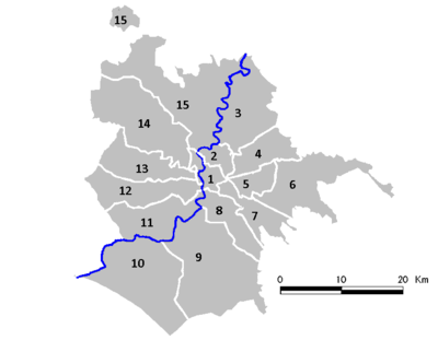 |
| Municipio II - Parioli/Nomentano | 167,736 | 19.60 | 8,567 | |
| Municipio III - Monte Sacro | 204,514 | 97.82 | 2,091 | |
| Municipio IV - Tiburtina | 177,084 | 49.15 | 3,603 | |
| Municipio V - Prenestino/Centocelle | 246,471 | 27.00 | 9,137 | |
| Municipio VI - Roma Delle Torri | 256,261 | 113.40 | 2,261 | |
| Municipio VII - Appio-Latino/Tuscolano/Cinecittà | 307,607 | 46.80 | 6,580 | |
| Municipio VIII - Appia Antica | 131,082 | 47.29 | 2,772 | |
| Municipio IX - EUR | 180,511 | 183.17 | 985 | |
| Municipio X - Ostia/Acilia | 230,544 | 150.64 | 1,530 | |
| Municipio XI - Arvalia/Portuense | 154,871 | 70.90 | 2,185 | |
| Municipio XII - Monte Verde | 140,996 | 73.12 | 1,928 | |
| Municipio XIII - Aurelia | 133,813 | 68.70 | 1,949 | |
| Municipio XIV - Monte Mario | 190,513 | 131.30 | 1,451 | |
| Municipio XV - Cassia/Flaminia | 158,561 | 186.70 | 849 |
Presidents of municipi
For the current legislature (2016–2021), presidents of Rome's municipi are:
| N. | President | Party | Mayoral majority | ||
|---|---|---|---|---|---|
| I | Sabrina Alfonsi | PD | |||
| II | Francesca Del Bello | PD | |||
| III | Giovanni Caudio | PD | |||
| IV | Roberta Della Casa | M5S | |||
| V | Giovanni Boccuzzi | M5S | |||
| VI | Roberto Romanella | M5S | |||
| VII | Monica Lozzi | M5S | |||
| VIII | Amedeo Ciaccheri | SI | |||
| IX | Dario D'Innocenti | M5S | |||
| X | Giuliana Di Pillo | M5S | |||
| XI | Mario Torelli | M5S | |||
| XII | Silvana Crescimanno | M5S | |||
| XIII | Giuseppina Castagnetta | M5S | |||
| XIV | Alfredo Campagna | M5S | |||
| XV | Stefano Simonelli | M5S | |||
List of historic Rioni in Rome's centre
| Rione | Name |
|---|---|
| R. I | Monti |
| R. II | Trevi |
| R. III | Colonna |
| R. IV | Campo Marzio |
| R. V | Ponte |
| R. VI | Parione |
| R. VII | Regola |
| R. VIII | Sant'Eustachio |
| R. IX | Pigna |
| R. X | Campitelli |
| R. XI | Sant'Angelo |
| R. XII | Ripa |
| R. XIII | Trastevere |
| R. XIV | Borgo |
| R. XV | Esquilino |
| R. XVI | Ludovisi |
| R. XVII | Sallustiano |
| R. XVIII | Castro Pretorio |
| R. XIX | Celio |
| R. XX | Testaccio |
| R. XXI | San Saba |
| R. XXII | Prati |
List of Rome's districts and zones outside the imperial walls (incomplete)
Acilia, Acqua Acetosa, Acqua Acetosa Ostiense, Alberone, Alessandrino, Appia-Pignatelli, Appio-Latino, Arco di Travertino, Ardeatino Aurelio, Axa, Balduina, Belsito, Boccea, Bravetta, Bufalotta, Caffarella, Camilluccia, Capannelle, Casal Bertone, Casal Boccone, Casal Bruciato, Casal del Marmo, Casal de' Pazzi, Casaletto, Casal Lumbroso, Casalotti, Casalpalocco, Casal Selce Case Rosse Casetta Mattei, Casilino 23, Cassia, Castel Giubileo, Castelverde, Cecchignola, Centocelle, Cesano, Cinecittà, Cinquina, Città Giardino, Colle di Mezzo, Colli Aniene, Colli Portuensi, Corviale, Dalmata, Delle Valli, Delle Vittorie, Divino Amore, Don Bosco, Dragona, Dragoncello, Due Ponti, EUR, Falcognana, Fidene, Finocchio, Flaminio, Fleming, Fonte Meravigliosa, Foro Italico, Garbatella, Gianicolense, Giardinetti, Grotta Perfetta, Grottarossa, Idroscalo, Infernetto, Labaro-Prima Porta, La Giustiniana, La Parrocchietta, La Romanina, La Storta, Laurentino 38, Lucchina, Lunghezza, Magliana, Malafede, Malagrotta, Mandrione, Marconi, Massimina, Medaglie d'Oro, Miani, Montagnola, Monte Antenne, Montecucco, Monte Mario, Monte Sacro, Montespaccato, Monteverde Nuovo, Monteverde Vecchio, Monti di Creta, Morena, Mostacciano, Muratella, Nomentano-Italia, Nuovo Salario, Olgiata, Osteria del Curato, Ostia, Ostiense, Ottavia, Ottavo Colle, Parco dei Medici, Parioli, Pietralata, Pigneto, Pineta Sacchetti, Pinciano, Pisana, Ponte Galeria, Ponte Mammolo, Ponte Milvio, Porta di Roma, Porta Maggiore, Portonaccio, Portuense, Prati Fiscali, Prato della Signora, Prenestino, Prima Porta, Primavalle, Quadraro, Quarticciolo, Quarto Miglio, Rebibbia, Roma 70, Salario, San Basilio, San Lorenzo, San Paolo, Santa Maria del Soccorso, Saxa Rubra, Selva Candida, Serpentara, Settebagni, Settecamini, Spinaceto, Statuario, Talenti, Tiburtino, Tomba di Nerone, Tor Bella Monaca, Tor Carbone, Tor de' Cenci, Tor di Quinto, Tor di Valle, Tor Marancia, Tor Pagnotta, Torpignattara, Torraccia, Torre Angela, Torre Spaccata, Torrevecchia, Torrino, Tor Sapienza, Tor Tre Teste, Tor Vergata, Tre Fontane, Trieste, Trigoria, Trionfale, Trullo, Tufello, Tuscolano, Val Cannuta, Valle Giulia, Valleranello, Vallerano, Verano, Vigna Clara, Vigna Murata, Valle Aurelia, Villa Certosa, Villaggio Olimpico, Vitinia.
References
- ↑ "Strutture territoriali" (in Italian). Comune di Roma. Retrieved 20 December 2013.
- ↑ "Roma, sì all'accorpamento dei municipi: il Consiglio li riduce da 19 a 15". Il Messaggero. 11 March 2013. Retrieved 13 March 2013.
- ↑ "The "Rioni" of Rome". Romeartlover.it. Retrieved 3 February 2010.
External links
![]()
| ||