Mundo (river)
| Río Mundo | |
|---|---|
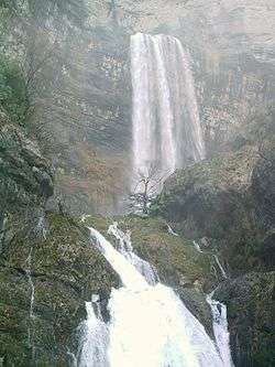 Source of the Mundo River | |
| Country | Spain |
| Physical characteristics | |
| Main source |
South of Riópar, Province of Albacete 1,300 m (4,300 ft) |
| River mouth | 300 m (980 ft) |
| Length | 150 km (93 mi)[1] |
| Discharge |
|
| Basin features | |
| Basin size | 766 km2 (296 sq mi)[1] |
The Mundo is a river in south-eastern Spain. It originates slightly south of Riópar in the mountain plateau Calar del Mundo. From there it flows towards Riopar and then westwards until it joins the Segura south of Hellín.[2]
The Mundo has a length of 150 km and a drainage area of 766 km2.[1] The river receives most of its tributaries in its upper course. They include the Rio de la Vega, the Rio de los Vadillos and the Rio de Bogarra. The Arroyo de Tobarra is the only significant tributary in its lower course.[2] There are two reservoirs along the coursenthe Mundo, the Talave reservoir with a volume of 34 cubic hectometres and the Camarillas reservoir with a volume of 36.5 cubic hectometres. At the Talave reservoir the Mundo receives additional water via a 250 km long aqueduct coming from reservoirs of the Tagus river.[3] The Camarillas reservoir triggered a series of small quakes when it was first filled in spring 1961, but the seismic activity finally ceased in spring 1962. [4]
The Mundo river is well known for its picturesque source, which is considered to be of the world most beautiful river sources. The river originates from a cave in the middle of a tall cliff and forms a waterfall with a height of almost 100 meters, subsequently the it forms a series of smaller cascades and pools. The cave itself is about 15 meters wide and 25 meters high and constitutes the end of a large cave system under the Calar del Mundo. [5]
See also
| Wikimedia Commons has media related to Mundo River. |
References
- 1 2 3 4 EL RÍO MUNDO, PRINCIPAL AFLUENTE DEL SEGURA auf chsegura.es (retrieved 2012-12-8)
- 1 2 map of hydrographic network and infrastructures auf chsegura.es (retrieved 2012-12-8)
- ↑ Juan B. Marco, R. Harboe: Stochastic Hydrology and Its Use in Water Resources Systems Simulation and Optimization. Springer 1993, ISBN 0792322886, S. 248 (Auszug (Google), p. 428, at Google Books)
- ↑ William C. Ackermann: Man-Made Lakes: Their Problems and Environmental Effects. American Geophysical Union, 1973, S. 448 (Auszug (Google), p. 448, at Google Books)
- ↑ Rolf Neuhaus: Wann birst die Welt? at faz.net on 2012-12-5 (German)