The Humps
| The Humps | |
| Hill | |
| Country | Australia |
|---|---|
| State | Western Australia |
| Region | Wheatbelt |
| Municipality | Shire of Kondinin |
| Elevation | 335 m (1,099 ft) |
| Prominence | 80 m (262 ft) |
| Coordinates | 32°19′04″S 118°57′26″E / 32.31785°S 118.95716°ECoordinates: 32°19′04″S 118°57′26″E / 32.31785°S 118.95716°E |
The Humps is a granite rock formation known as a "stepped bornhardt inselberg".[1] It is located within The Humps Nature Reserve approximately 295 kilometres (183 mi) east of Perth and 17 kilometres (11 mi) north east of Hyden in the eastern wheatbelt region of Western Australia.[2][3][4][5]
Rising about 80 metres (260 ft) above the surrounding plains, The Humps is one of numerous rock formations in the area.[1] Approximately 15 kilometres (9.3 mi) to its south is Hyden Rock whose northern side features the Wave Rock formation. Also in the area are Scrivener Rocks and Camel Peaks roughly 13 kilometres (8.1 mi) west of The Humps, Anderson Rocks about 19 kilometres (12 mi) north, and King Rocks approximately 18 kilometres (11 mi) east of The Humps.[1]
Mulka's Cave
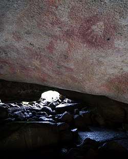
On the north-eastern edge of The Humps is Mulka's Cave, also known as Bate's Cave.[6][7][8][2][9] This "Aboriginal site is a decorated rock shelter"[2] featuring "over 450 separate hand prints and images"[8], "an extremely high number for the region where most sites have fewer than 30 motifs".[2] While visitation has damaged the site, mitigation strategies put into place appear to have arrested further damage.[5]
Mulka's Cave is "protected under the Aboriginal Heritage Act". Furthermore, being "of outstanding significance", Mulka's Cave is also both a Protected Area and listed on the Register of the National Estate.[6]
Walks
The Humps Nature Reserve has two marked walking trails.[6][7] Gnamma Trail is approximately 1,220 metres (4,000 ft) long over flat terrain, offering access to "two Gnamma (rock holes) and a lizard trap, all believed to have been used by Noongar people for centuries."[6] In contrast, Kalari Trail is approximately 1,670 metres (5,480 ft) long and ascends "steadily (but not steeply) to the summit, which affords outstanding panoramic views of the outlying farming land" and permits focus on the geology and vegetation along the way.[6]
Reservoir
Water run-off from The Humps is directed into the Hyden Humps Dam reservoir.[10] The reservoir is situated approximately 200 metres (660 ft) south of The Humps.
See also
References
- 1 2 3 Twidale, C R; Bourne, J A (September 2004). "Notes on the Geomorphology of the Humps, Near Hyden, Western Australia" (PDF). Journal of the Royal Society of Western Australia. 87 (3): 123–133. Retrieved 22 August 2018.
- 1 2 3 4 Gunn, R. G. (2006). "Mulka's Cave Aboriginal Rock Art Site: Its Context and Content" (PDF). Records of the Western Australian Museum. 23: 19–41. Retrieved 22 August 2018.
- ↑ "Pathways to Wave Rock" (PDF). Shire of Kulin. 2013. Retrieved 23 August 2018.
- ↑ "Wave Rock". Western Australian Visitor Information Centre. 13 August 2018. Retrieved 23 August 2018.
- 1 2 Rossi, A. M.; Webb, R. E. (November 2007). "The Consequences of Allowing Unrestricted Tourist Access at an Aboriginal Site in a Fragile Environment: the Erosive Effect of Trampling" (PDF). Conservation and Management of Archaeological Sites. 9 (4): 219–236. doi:10.1179/175355207X404197. Retrieved 24 August 2018.
- 1 2 3 4 5 "Explore the Humps and Mulka's Cave". Wave Rock Hotel/Motel. 2018. Retrieved 23 August 2018.
- 1 2 "Walk trails at Wave Rock and The Humps" (PDF). Central Wheatbelt Visitor Centre. January 2018. Retrieved 23 August 2018.
- 1 2 "The Wave Rock 2 Day Experience Visitor's Guide" (PDF). Kondinin Shire. October 2012. Retrieved 23 August 2018.
- ↑ "The Open Wheatbelt Trail" (PDF). The Royal Automobile Club of WA. 2017. Retrieved 23 August 2018.
- ↑ "Hyden Rock Dam – Heritage Council of WA – Places Database". Heritage Council, Government of Western Australia. 1 January 2017. Retrieved 23 August 2018.