Mule Keys
The Mule Keys are a group of scattered islets in the Florida Keys in Monroe County, Florida, United States. They are between 3 and 12 miles (5–20 km) west of Key West, separated from it by the Northwest Channel. On the west, they are separated from the Marquesas Keys by the 6-mile (10 km) wide Boca Grande Channel. They belong to the outlying islands of the Florida Keys. Administratively, they are an unincorporated area of Monroe County. The islets are part of the Key West National Wildlife Refuge. The area of the islets totals 1.07 mi2 (2.77 km2), of which 1.02 mi2 (2.63 km2) are land area and 0.05 mi2 (0.14 km2) inland water bodies (on three of the keys). The islets are uninhabited except for Mule Key, for which the census of 2000 lists one housing unit with a population of two (park rangers or coast guard).
The United States Government has placed most of this area off limits, as a part of the Key West National Wildlife Refuge. It is even prohibited to anchor off Man Key and Woman Key in the sand, although Woman Key was a popular destination for day trippers from Key West in the past, which Boca Grande Key still is. Anchoring off the south part of Boca Grande Key is also prohibited; it is permitted only off the northwest portion.[1]
Ballast Key is privately owned and offered on the real estate market for US $13,800,000, as of July 2011.[2]
The easternmost islet, Mule Key, is 2.7 miles (4.4 km) west of Sunset Key which is part of Key West city. The westernmost (and largest) islet, Boca Grande Key, is 6 miles (10 km) east of the Marquesas Keys.
12 individual islets are named on detailed topographical maps:
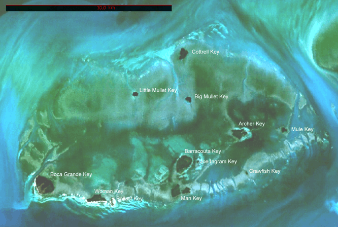
On nautical maps, the Mule Keys appear like an atoll of 11 miles (18 km) length east-west, and 6 miles (10 km) width north-south (covering a sea area of roughly 58 mi2 (150 km2)), with Mule Key, Crawfish Key, Man Key, Ballast Key, Woman Key and Boca Grande Key along the southern rim (from east to west), and Cottrell Key in the north.
7 miles (11 km) south of Mule Key, separated from the Mule Keys by West Channel, are three notable submerged reefs, from east to west:
- Eastern Dry Rocks, at 24°27′42.6″N 81°50′38.1″W / 24.461833°N 81.843917°W
- Rock Key, at 24°27′21.3″N 81°51′26.3″W / 24.455917°N 81.857306°W
- Sand Key, at 24°27′18.3″N 81°52′37.5″W / 24.455083°N 81.877083°W
See also
References
- ↑ "Key West Islands". Bootkeyharbor.com. Archived from the original on 2012-02-10. Retrieved 2012-02-27.
- ↑ "Inquire about Ballast Key". Privateislandsonline.com. Archived from the original on 2012-02-24. Retrieved 2012-02-27.