Mudeirej Bridge
| Jisr el Mdeirej | |
|---|---|
| جسر المديرج | |
 | |
| General information | |
| Status | Complete |
| Type | Bridge |
| Location | Sawfar, Mount Lebanon, |
| Town or city | Mdeirej |
| Country | Lebanon |
| Elevation | 1320 meters (4331 feet) |
| Completed | 1998 |
| Renovated | August 2008 |
| Destroyed | 12 July 2006 |
| Cost | 44 million USD |
| Height | 80 meters (263 feet) |
| Technical details | |
| Structural system | Triple T-section girder bridge |
| Design and construction | |
| Structural engineer | Khatib & Alami |
| Main contractor | TOTO Costruzion |
| Awards and prizes | Highest Bridge in the Middle East |
| Designations | Connects the Beirut-Damascus Highway |
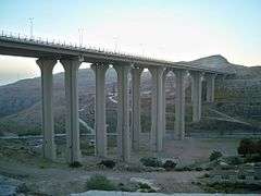
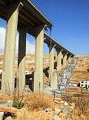
The Mudeirej Bridge or Mdairej Bridge is a notable bridge in Lebanon. It was completed in 1998 as the tallest and highest bridge in Lebanon and the Middle East. The bridge was built as part of Rafik Hariri's vision of rebuilding and developing Lebanon and its infrastructure. The bridge served as a connecting route for the Beirut-Damascus Highway aiming to improve the main road that links Syria's capital city Damascus, to Lebanon and its capital city Beirut.[1]
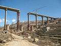
Destruction
On the 12th of July during the 2006 Lebanon-Israel conflict the Israeli Air force bombed the Mdeirej Bridge causing partial damage to its base and pillars, and critical damage to the road it uplifted. The destruction of the bridge which was a symbol of Lebanese architectural pride was considered by many in Lebanon to be unjustified because in their opinion, there was no strategic value to the bridge in Israeli's conflict with Hezbollah. According to one observer of the bombing, “The bombing of this bridge, which is the pride of the Lebanese people, clearly proves that Israel is committed to destroying the infrastructure of the whole country. This bridge is not used by Hezbollah since it lies in a mountain resort area of Mount Lebanon, far away from the south of Lebanon." [1]
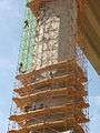
In 2008, USAID announced that it would be involved in an extensive reconstruction of the bridge, due to Lebanon's political victory which put Israel and the United States in an awkward position in regards to the destruction and reconstruction of the bridge.
Reconstruction work
References
- 1 2 "Israel destroys the highest bridge in Lebanon". Ya Libnan, Turkish Press. July 22, 2006. Archived from the original on July 3, 2008. Retrieved January 30, 2009.
External links
Coordinates: 33°48′3.0″N 35°43′37.5″E / 33.800833°N 35.727083°E