Mud Lake, Minnesota
| Mud Lake | |
|---|---|
| Unorganized territory | |
 Mud Lake  Mud Lake | |
| Coordinates: 48°19′26″N 95°54′48″W / 48.32389°N 95.91333°WCoordinates: 48°19′26″N 95°54′48″W / 48.32389°N 95.91333°W | |
| Country | United States |
| State | Minnesota |
| County | Marshall |
| Elevation | 1,145 ft (349 m) |
| Population (2000) | |
| • Total | 0 |
| Time zone | UTC-6 (Central (CST)) |
| • Summer (DST) | UTC-5 (CDT) |
| GNIS feature ID | 665062[1] |
Mud Lake is an unorganized territory located in Marshall County, Minnesota, United States.[1] As of the 2000 census, the unorganized territory had a total population of 0.
History
Mud Lake was organized as Mud Lake Township, and named for a former lake that has since been drained.[2]
Geography
According to the United States Census Bureau, the unorganized territory has a total area of 36.0 square miles (93.2 km²), of which 31.3 square miles (81.1 km²) of it is land and 4.7 square miles (12.1 km²) of it (13.03%) is water.
Demographics
As of the census[3] of 2000, there are no people living in the unorganized territory.
References
- 1 2 "Unorganized Territory of Mud Lake, Minnesota". Geographic Names Information System. United States Geological Survey.
- ↑ Upham, Warren (1920). Minnesota Geographic Names: Their Origin and Historic Significance. Minnesota Historical Society. p. 329.
- ↑ "American FactFinder". United States Census Bureau. Retrieved 2008-01-31.
Municipalities and communities of Marshall County, Minnesota, United States | ||
|---|---|---|
| Cities | 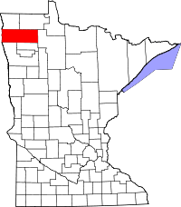 | |
| Townships |
| |
| Unincorporated communities | ||
| Unorganized territory | ||
| Indian reservation | ||
| Footnotes | ‡This populated place also has portions in an adjacent county or counties | |
This article is issued from
Wikipedia.
The text is licensed under Creative Commons - Attribution - Sharealike.
Additional terms may apply for the media files.