Mud Bay, Thurston County, Washington
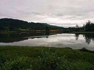
Mud Bay is the southernmost reach of Puget Sound, at Eld Inlet just outside the city limits of Olympia, Washington.[1][2][3] The name Eld Inlet was officially bestowed after a member of the U.S. Navy's Wilkes Expedition, but "Mud Bay" is a local, informal adoption.[4][5]:217
It was once a highly productive ground for the Olympia Oyster. The first Indian Shaker Church building was constructed above the bay c. 1890, Mud Bay being the home of the founder Sam "Mud Bay Sam" Yowaluch, the first Bishop of the church.[6]:3
The Mud Bay Logging Company ran a railroad to the bay where they had a log dump.
Landmarks and attractions
A roadside attraction was placed at the bay near U.S. Highway 101 in 2002: a set of larger-than-life metal sculptures of cows and a bull created by Western Washington sculptor Gary Vig. The bull is 22 feet (6.7 m) long and weighs 3 tons.[7][8][9]
An interpretive sign about the landing of Peter Puget at Mud Bay was placed by the county's historical commission along Mud Bay Road.[10] The William Cannon Footpath (or Trail) is a 4,000-foot (1,200 m) long public-access trail built in 2002 along the bayshore in the vicinity of the log dump, in partnership with Ralph Munro, McLane Elementary School, Capital High School, NOAA, and others.[11][12]
The Blue Heron Bakery was a local landmark whole-grain bakery on the edge of the bay from 1978 until 2015 when it moved about a mile east into Olympia.[13][14]
The Mud Bay Indian Shaker Church, the first church building of that religion, was built on the shoulder of the Black Hills overlooking the bay in 1885.
Events
The Mud Bay Run is a traditional annual, 500-meter clothing-optional race across the mud flats at low tide. It is held on the day of, and just before, The Evergreen State College's graduation procession.[15]
Notable people
People from the Mud Bay area include:
- Mud Bay Sam Yowaluch, cofounder and Bishop of the Indian Shaker Church[6]:3
- Mud Bay Louie Yowaluch, Sam's brother and cofounder of the Indian Shaker Church[6]:3
- Angeline Tobin Frank, of the Squaxin Island Tribe, mother of Nisqually Tribe chairman Billy Frank, Jr., grew up within an oyster farming family on Mud Bay.[16]:37
- William McLane and Martha McLeod McLane, homesteaders on Mud Bay c. 1852. William McLane served several terms in the Washington Territorial Legislature.
References
- ↑ Tacoma Public Library 2015.
- ↑ USGS Geographic Names Information System.
- ↑ Hitchman 1985, p. 201.
- ↑ Crooks 2012.
- ↑ Meany 1923.
- 1 2 3 Washington Secretary of State 1996.
- ↑ Kirby 2008.
- ↑ Faltys 2012.
- ↑ Hahn 2002.
- ↑ Puget Memorial Project 2014.
- ↑ William Cannon Footpath, Outdoor Activity of the Month (PDF), Squaxin Island Tribe, July 2011
- ↑ William Cannon Trail Habitat Restoration, Olympia, Washington: People for Puget Sound
- ↑ Fender 2013.
- ↑ Boone 2015.
- ↑ "What do you love? 40 things.", The Evergreen Magazine, The Evergreen State College (Spring issue), 2012, retrieved August 29, 2015
- ↑ Heffernan 2012.
- Sources
- "Mud Bay record", Washington Place Names database, Tacoma Public Library, archived from the original on May 23, 2008, retrieved August 29, 2015
- "Washington churches", INDIAN SHAKER CHURCH OF WASHINGTON, RECORDS (PDF), Washington Secretary of State, c. 1996, pp. 16–17, Ms 29
- U.S. Geological Survey Geographic Names Information System: Mud Bay
- Doug Kirby, Ken Smith, Mike Wilkins, eds. (2008), "Metal Cows", Roadside America
- Faltys, Doris (November 28, 2012), "Who Created The Cows – A Follow-Up Story To Olympia's Mud Bay Mystery", Thurston Talk
- "A New Peter Puget Historic Marker in Mud Bay, Eld Inlet", Lt. Peter Puget Memorial Project, January 15, 2014
- Crooks, Drew (December 16, 2012), "History Behind The Place Name: Budd Inlet", Thurston Talk
- Hahn, Jon (October 16, 2002), "Artist drives mammoth steel cattle to Olympia", Seattle Post-Intelligencer
- Boone, Rolf (July 5, 2015), "Blue Heron Bakery: Bigger, better location", The Olympian
- Fender, Jackie (October 31, 2013), "Urban Spelunker: West Olympia: Shops, eats and treats in Olympia's westside", Northwest Military, Lakewood, Washington
- Books
- Meany, E.S. (1923), Origin of Washington Geographic Names, University of Washington Press
- Heffernan, Trova (2012), Where the Salmon Run: The Life and Legacy of Billy Frank Jr. (PDF), Washington State Heritage Center Project and University of Washington Press, ISBN 978-0-295-99178-8 – via Washington Secretary of State
- Hitchman, Robert (1985), Place Names of Washington, Tacoma, Wash: Washington State Historical Society, ISBN 0-917048-57-1
Further reading
- Davies, Bruce (2011), Tobin Cemetery (History of Mud Bay Indian community), Squaxin Island Tribe — including oral histories, maps, genealogical chart, and records of burials at three Indian cemeteries including McLane Cemetery and Tobin Cemetery in vicinity of Mud Bay. Includes bibliography.
External links

Coordinates: 47°04′57″N 122°59′21″W / 47.08250°N 122.98917°W