Muckle Roe
| Norse name | Rauðøy Mikla[1] |
|---|---|
| Meaning of name | big red island |
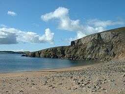 Muckle Ayre Beach | |
| Location | |
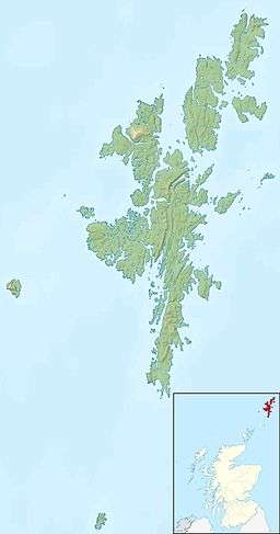 Muckle Roe Muckle Roe shown within the Shetland Islands | |
| OS grid reference | HU317650 |
| Coordinates | 60°22′N 1°25.5′W / 60.367°N 1.4250°WCoordinates: 60°22′N 1°25.5′W / 60.367°N 1.4250°W |
| Physical geography | |
| Island group | Shetland |
| Area | 1,773 hectares (6.8 sq mi) |
| Area rank | 37 [2] |
| Highest elevation | Mid Ward 172 metres (564 ft)[3] |
| Administration | |
| Sovereign state | United Kingdom |
| Country | Scotland |
| Council area | Shetland Islands |
| Demographics | |
| Population | 130[4] |
| Population rank | 43 [2] |
| Population density | 7.3people/km2[4][5] |
| Largest settlement | Roesound |
| References | [3][5][6][7] |
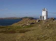 Muckle Roe Lighthouse | |
| Location |
Shetland, Scotland, United Kingdom |
|---|---|
| Coordinates | 60°20′57″N 1°27′03″W / 60.349232°N 1.450732°W |
| Year first constructed | 1897 (first) |
| Year first lit | 2001 (current) |
| Deactivated | 2001 (first) |
| Foundation | concrete base |
| Construction |
metal skeletal tower (current) cast iron tower (first) |
| Tower shape |
quadrangular tower covered by aluminium panels with light on the top (current) octagonal tower with balcony and lantern |
| Markings / pattern | white tower |
| Height |
7 metres (23 ft) (current) 8 metres (26 ft) (first) |
| Focal height | 30 metres (98 ft) (current) |
| Original lens | 3rd order Fresnel lens (first) |
| Light source | solar power (current) |
| Characteristic | Fl WR 3s.[8] |
| Admiralty number | A3844 |
| NGA number | 3552 |
| ARLHS number | SCO-141 |
| Managing agent | Northern Lighthouse Board[9] |
Muckle Roe is an island in Shetland, Scotland, in St. Magnus Bay, to the west of Mainland, Shetland. It has a population of around 130 people, who mainly croft and live in the south east of the island.[7][10]
'Muckle' is Scots for 'big' or 'great'.
History
The island is referred to in the Orkneyinga saga.[11]
In 1905 a bridge was built between Muckle Roe and the Shetland Mainland over Roe Sound at a cost of £1,020 met from public subscription and a grant from the Congested Districts Board. The construction was of iron and concrete[7][12] and its completion was followed by a reversal in the population decline seen in the 19th and earlier 20th centuries. A replacement bridge was built in 1999.
Muckle Roe was part of the civil parish of Delting until the abolition of civil parishes in Scotland by the Local Government (Scotland) Act 1929.
Geography and geology
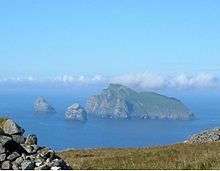
Muckle Roe is approximately 3 miles (4.8 km) in diameter, with high cliffs in the south. Its highest point is Mid Ward 172 metres (564 ft).
The island's rock is red granite,[10] which gives the island its name – a combination of Scots and Old Norse meaning "big red island".[5][7]
There are crofts in the east and south east. The rest of the island is lochan-studded moorland.[13]
Population
| 1851 | 290 |
| 1871 | 216 |
| 1881 | 230 |
| 1961 | 103 |
| 1971 | 94 |
| 1981 | 101 |
| 1991 | 115 |
| 2001 | 104 |
| 2011 | 130 |
| source: [4][5] | |
See also
Notes
- ↑ Waugh (2007) p. 541
- 1 2 Area and population ranks: there are c. 300 islands over 20 ha in extent and 93 permanently inhabited islands were listed in the 2011 census.
- 1 2 Ordnance Survey. OS Maps Online (Map). 1:25,000. Leisure.
- 1 2 3 National Records of Scotland (15 August 2013) (pdf) Statistical Bulletin: 2011 Census: First Results on Population and Household Estimates for Scotland - Release 1C (Part Two). "Appendix 2: Population and households on Scotland’s inhabited islands". Retrieved 17 August 2013.
- 1 2 3 4 Haswell-Smith (2004) p. 406
- ↑ Fraser, Allen (2002) The Edinburgh Geologist: Old Norse and Norn names in Shetland. Issue 39 Archived 16 May 2007 at the Wayback Machine. Retrieved 14 April 2007.
- 1 2 3 4 Keay & Keay, (1994) p. 711
- ↑ Muckle Roe marinetraffic.com. Retrieved 31 May 2016
- ↑ Muckle Roe (Swarbacks Minn) The Lighthouse Directory. University of North Carolina at Chapel Hill. Retrieved 31 May 2016
- 1 2 Haswell-Smith (2004) p. 440
- ↑ Anderson, Joseph (Ed.) (1893) Orkneyinga Saga. Translated by Jón A. Hjaltalin & Gilbert Goudie. Edinburgh. James Thin and Mercat Press (1990 reprint). ISBN 0-901824-25-9
- ↑ Nicolson (1972) p. 108
- ↑ "Overview of Muckle Roe". Gazetteer for Scotland. Retrieved 2008-01-06.
References
- Haswell-Smith, Hamish (2004). The Scottish Islands. Edinburgh: Canongate. ISBN 978-1-84195-454-7.
- Keay, J. & Keay, J. (1994) Collins Encyclopaedia of Scotland. London. HarperCollins.
- Nicolson, James R. (1972) Shetland. Newton Abbott. David & Charles.
- Waugh, Doreen "Placing Papa Stour in Context" in Ballin Smith, Beverley; Taylor, Simon; and Williams, Gareth (2007) West over Sea: Studies in Scandinavian Sea-Borne Expansion and Settlement Before 1300. Leiden. Brill. ISBN 97890-04-15893-1
External links
| Wikimedia Commons has media related to Muckle Roe. |
| Inhabited islands | ||
|---|---|---|
| Other islands | ||
| Towns and villages | ||
| Mainland Parishes | ||
| Insular Parishes | ||
| Maritime features | ||
Extreme points
| ||
| Topics | ||
|  | ||||||||||||||||
|
| |||||||||||||||||
| |||||||||||||||||
| |||||||||||||||||
| |||||||||||||||||
| |||||||||||||||||
| |||||||||||||||||
| |||||||||||||||||